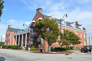
Sampson County, North Carolina

Last updated

Sampson County
Sampson County Courthouse, Clinton.jpg
Sampson County Courthouse in Clinton
Sampson County Seal.jpg
Sampson County Logo.png
Map of North Carolina highlighting Sampson County.svg
Location within the U.S. state of North Carolina
North Carolina in United States.svg
North Carolina's location within the U.S.
Coordinates: 34°59′N78°22′W / 34.99°N 78.37°W / 34.99; -78.37
CountryFlag of the United States.svg United States
StateFlag of North Carolina.svg  North Carolina
Founded1784
Named for John Sampson
Seat Clinton
Largest communityClinton
Area
  Total947.83 sq mi (2,454.9 km2)
  Land945.93 sq mi (2,449.9 km2)
  Water1.90 sq mi (4.9 km2)  0.20%
Population
 (2020)
  Total59,036
  Estimate 
(2023)
59,601
  Density62.41/sq mi (24.10/km2)
Time zone UTC−5 (Eastern)
  Summer (DST) UTC−4 (EDT)
Congressional district 3rd
Website www.sampsonnc.com

Sampson County is a county located in the U.S. state of North Carolina. As of the 2020 census, the population was 59,036. [1] Its county seat is Clinton. [2]

Contents

History

Sampson County was established in April 1784 following the American Revolutionary War. The North Carolina General Assembly annexed land from the neighboring Duplin County. The neighboring Wayne County and New Hanover counties would be annexed later.

Early settlers were Scots-Irish immigrants from Northern Ireland, many came to colonial North Carolina under the protection and inducements of Henry McCulloch, a wealthy London merchant. The community of Taylors Bridge was one of the earliest European settled areas of the county. Pioneer families lived there as early as the 1730s or 1740s. The first settlers of the area were Edmond Matthis, William Johnson, William Robinson and John Register, followed by members of the Peterson, Knowles, Vann, Boney, Merritt, Pearson, Powell, Herring, Rogers, Bryant, Blue, Ezzell, James Murphy, Ward, Sellers, Parrish, Fryar, Williamson and Bass families. In 1745, McCulloch obtained grants from the British Crown covering some 71,160 acres of land "lying and situated on the branches of the North East and Black River." [3] The Scot-Irish immigrants were soon joined by descendants of the Swiss colony in New Bern. Later on, they were joined by pioneers from the northern states of New Jersey, Connecticut and Massachusetts.

Among the first European settlers of the area was John Sampson. Sampson was appointed as the first Register of Deeds for Duplin County. He served as a Lt. Colonel, and then a Lt. General in the county's militia, and was later elected as the first mayor of Wilmington. Sampson brought with him Richard Clinton, believed to be his stepson.

As an adult, Clinton soon distinguished himself in governmental and military service, serving as Duplin County's Register of Deeds for ten years. He was elected to the Provincial Congress held at Hillsboro. In 1776, at the outbreak of the Revolution, Clinton organized a company of militia from upper Duplin County and led them as captain in the defense of Wilmington against the British. He was later appointed Colonel of Cavalry and Brigadier General of the Fayetteville District. Upon the establishment of the state government of North Carolina by the Halifax Constitution of 1776, Clinton was elected as one of the first members of the House of Commons, representing the County of Duplin as a House member. Clinton continued as a representative of Duplin County until the creation of Sampson County in 1784. Clinton secured passage of the act creating the new county, and proposed the name "Sampson" in honor of John Sampson, his stepfather and benefactor.

According to the 2000 census, there were 1,029 members of the state-recognized Coharie Intra-tribal Council, Inc., a state-recognized tribe in Sampson County, who claim "descent from certain tribes of Indians originally inhabiting the coastal regions of North Carolina." [4]

George Edwin Butler, author of The Croatan Indians of Sampson County, North Carolina. Their Origin and Racial Status. A Plea for Separate Schools (1916), claimed that the Croatan were mixed-race descendants of English settlers on the Lost Colony of Roanoke Island. The persons associated as Croatan were variously classified as "White", "Mulatto", "Colored", and "Negro" in the censuses of the 19th century. There was no category for Indian.

But most historians do not believe the myth of the Croatan Indians in North Carolina. No records exist of any English settlement inland of the North Carolina coast prior to 1703, when John Lawson explored the inner region of the territory. Butler claimed that Lawson had come across Native Americans who were tilling the land in the English style, speaking an antiquated English, having gray and blue eyes, and wanting Lawson to teach them how to "speak from a book" as their forefathers did. [5] Mainline historians have found no evidence that any Europeans survived from Roanoke Island. DNA analysis of the "Indians" of Sampson County have not supported such early 20th c. myths.

Geography

Sampson County, North Carolina
Interactive map of Sampson County

According to the U.S. Census Bureau, the county has a total area of 947.83 square miles (2,454.9 km2), of which 945.93 square miles (2,449.9 km2) is land and 1.90 square miles (4.9 km2) (0.20%) is water. [6] It is the second-largest county by land area, behind only Robeson County, which has a land area of 949.26 square miles (2,458.6 km2). [6]

The county is in the watersheds of the Black and South Rivers and Six Run Creek.

State and local protected areas

Major water bodies

Adjacent counties

Major highways

Major infrastructure

Demographics

Historical population
CensusPop.Note
1790 6,162
1800 6,7199.0%
1810 6,620−1.5%
1820 8,90834.6%
1830 11,63430.6%
1840 12,1574.5%
1850 14,58520.0%
1860 16,62414.0%
1870 16,436−1.1%
1880 22,89439.3%
1890 25,0969.6%
1900 26,3805.1%
1910 29,98213.7%
1920 36,00220.1%
1930 40,08211.3%
1940 47,44018.4%
1950 49,7804.9%
1960 48,013−3.5%
1970 44,954−6.4%
1980 49,68710.5%
1990 47,297−4.8%
2000 60,16127.2%
2010 63,4315.4%
2020 59,036−6.9%
2023 (est.)59,601 [1] 1.0%
U.S. Decennial Census [10]
1790–1960 [11] 1900–1990 [12]
1990–2000 [13] 2010 [14] 2020 [1]

2020 census

Sampson County racial composition [15]
RaceNumberPercentage
White (non-Hispanic)29,72950.36%
Black or African American (non-Hispanic)13,94423.62%
Native American 1,0021.7%
Asian 2160.37%
Pacific Islander 180.03%
Other/Mixed 1,8783.18%
Hispanic or Latino 12,24920.75%

As of the 2020 census, there were 59,036 people, 23,416 households, and 15,705 families residing in the county.

2010 census

At the 2010 census, [16] there were 63,431 people, 22,624 households, and 16,214 families residing in the county. The population density was 67.1 people per square mile (25.9 people/km2). There were 26,476 housing units at an average density of 27 units per square mile (10 units/km2). The racial makeup of the county was 56.7% White, 27% Black or African American, 2% Native American, 0.4% Asian, 0.1% Pacific Islander and 2% from two or more races. 16.5% of the population were Hispanic or Latino of any race.

There were 22,273 households, out of which 33.40% had children under the age of 18 living with them, 53.60% were married couples living together, 14.30% had a female householder with no husband present, and 27.20% were non-families. 23.70% of all households were made up of individuals, and 10.20% had someone living alone who was 65 years of age or older. The average household size was 2.64 and the average family size was 3.09.

In the county, the population was spread out, with 25.80% under the age of 18, 9.40% from 18 to 24, 29.70% from 25 to 44, 22.30% from 45 to 64, and 12.80% who were 65 years of age or older. The median age was 35 years. For every 100 females there were 98.20 males. For every 100 females age 18 and over, there were 95.90 males.

The median income for a household in the county was $31,793, and the median income for a family was $38,072. Males had a median income of $26,806 versus $20,657 for females. The per capita income for the county was $14,976. About 13.50% of families and 17.60% of the population were below the poverty line, including 21.50% of those under age 18 and 21.50% of those age 65 or over.

Sampson County is also one of the largest producers of hogs in the nation, and second in the state, with a population of over 2 million hogs.

Government and politics

Currently, Sampson County leans strongly towards the Republican Party in presidential elections. No Democratic presidential candidate has gained an absolute majority of Sampson County's votes in a presidential election since Jimmy Carter did so in 1980, although Bill Clinton won a plurality in 1992 and Bob Dole's 1996 plurality was just ninety-one votes out of over seventeen thousand.

Historically, the county was unusual in the South in turning strongly towards the Republican Party between the 1890s and World War II – a time when most of the region was solidifying as the overwhelmingly Democratic "Solid South". Even with its historic Populism a fading memory, and no Unionist history, Sampson was one of seven North Carolina counties to vote for Wendell Willkie in 1940, and one of fourteen to vote for Thomas E. Dewey in 1944. This was due to the fact that it was the leading center for the Populist Party during the 1890s under local hero Marion Butler – more so indeed than Nash and Chatham counties which had given James B. Weaver a plurality in the 1892 election – and the fact that to compete with the dominant Democratic Party the two would fuse, with the result that after the Populists' demise its adherents turned to the Republicans. [17]

United States presidential election results for Sampson County, North Carolina [18]
Year Republican Democratic Third party
No.%No.%No.%
2020 17,41160.84%10,96638.32%2410.84%
2016 14,83857.23%10,54740.68%5432.09%
2012 14,42255.10%11,56644.19%1860.71%
2008 14,03853.91%11,83645.46%1640.63%
2004 12,60056.53%9,64943.29%390.17%
2000 10,41054.11%8,76845.57%610.32%
1996 8,24147.82%8,15047.30%8414.88%
1992 8,00743.12%8,69846.84%1,86310.03%
1988 8,52451.49%8,00948.38%220.13%
1984 10,66553.87%9,11546.04%160.08%
1980 8,09746.06%9,09051.71%3912.22%
1976 6,96843.82%8,86955.77%650.41%
1972 9,68465.76%4,88833.19%1541.05%
1968 6,59741.44%4,79730.13%4,52728.43%
1964 7,63448.62%8,06751.38%00.00%
1960 7,33849.02%7,63250.98%00.00%
1956 6,68548.16%7,19751.84%00.00%
1952 6,44948.11%6,95651.89%00.00%
1948 4,93246.76%4,96547.07%6516.17%
1944 6,06258.96%4,22041.04%00.00%
1940 5,76953.04%5,10746.96%00.00%
1936 4,94845.46%5,93754.54%00.00%
1932 4,12745.09%4,91153.66%1141.25%
1928 5,57970.94%2,28529.06%00.00%
1924 3,18860.79%2,02138.54%350.67%
1920 5,35368.81%2,42631.19%00.00%
1916 2,72766.58%1,36933.42%00.00%
1912 842.17%1,26532.69%2,52165.14%

In the North Carolina House of Representatives, Sampson County is in the 22nd District with Bladen County, represented by Republican William D. Brisson, [19] In the North Carolina Senate, it lies within the 9h Senate District, represented by Republican Brent Jackson. [20]

Sampson County is a member of the regional Mid-Carolina Council of Governments.

Economy

Historically, Sampson County has been an agricultural county with a slow rise in population since the creation of the county. The agricultural sector continues to be one of the leading pillars of the economy. Leading industries prior to the 20th century were naval stores, timber and agriculture. After the Civil War, the Naval Stores and timber industries began to lose production value in the county to the lack of cheap labor due to the eradication of slavery among other factors; as a result, subsistence agriculture became the primary industry. The county has steadily gained stronger manufacturing and services industries since the Civil War. [21]

As of 2007, agricultural land covered over 50% of the county's land area. [22] A wide range of crops are grown in the county ranging from vegetables, fruits and berries to tobacco, peanuts, corn, soybeans and wheat. Manufacturing, agriculture, healthcare, education and retail are the primary sources of employment in the county.

As of 2012, Sampson County is the largest producer of hay and flue-cured tobacco in North Carolina. Sampson County is the largest producer of turkeys and the second largest producer of hogs in the state. [23]

Education

Sampson County has a county-wide public school system for the grades of K-12 with the exception of the city of Clinton, which has its own public school district for grades K-12. The only post-secondary public institution in the county is Sampson Community College. Hobbton High School is the oldest school building in Sampson County; located in Newton Grove, it is a small 1A school.

County schools

Elementary schools
  • Clement
  • Hargrove
  • Hobbton
  • Midway
  • Plain View
  • Roseboro
  • Salemburg
  • Union
Intermediate school
Middle schools
High schools

Clinton City Schools

Elementary schools
Middle school
High school

Libraries

The Sampson County Library System serves Sampson County residents through four different libraries and a specialized outreach service intended for patrons who are home-bound and unable to visit the library. The libraries share a publicly accessible catalog and courier service. The Sampson County Library System offers online resources including eBooks, audiobooks, numerous genealogy databases, and online Driver's Education. The libraries also participate in Interlibrary Loan services. Computer classes and Story Time programs are offered at the member libraries.

Library Locations

The J.C. Holliday Library in Clinton is the headquarters library for the county. It houses the largest collection of items including research materials and a local history and genealogy collection. There are also reference and children's services provided at this branch. [24]

Communities

Map of Sampson County with municipal and township labels Map of Sampson County North Carolina With Municipal and Township Labels.PNG
Map of Sampson County with municipal and township labels

City

Towns

Census-designated places

Unincorporated communities

Townships

  • Belvoir
  • Dismal
  • Franklin
  • Halls
  • Herring
  • Honeycutt
  • Lisbon
  • Little Coharie
  • McDaniels
  • Mingo
  • Newton Grove
  • North Clinton
  • Piney Grove
  • Plain View
  • South Clinton
  • South River
  • Taylors Bridge
  • Turkey
  • Westbrook

Notable people

See also

Related Research Articles

<span class="mw-page-title-main">Pender County, North Carolina</span> County in North Carolina, United States

Pender County is a county located in the U.S. state of North Carolina. As of the 2020 census, the population was 60,203. Its county seat is Burgaw. Pender County is part of the Wilmington, NC Metropolitan Statistical Area.

<span class="mw-page-title-main">Onslow County, North Carolina</span> County in North Carolina, United States

Onslow County is a county located in the U.S. state of North Carolina. As of the 2020 census, the population was 204,576. Its county seat is Jacksonville. The county was created in 1734 as Onslow Precinct and gained county status in 1739. Onslow County comprises the Jacksonville, NC Metropolitan Statistical Area. The southern border is the coast of the Atlantic Ocean.

<span class="mw-page-title-main">Jones County, North Carolina</span> County in North Carolina, United States

Jones County is a county located in the U.S. state of North Carolina. As of the 2020 census, the population was 9,172, making it the fourth-least populous county in North Carolina. Its county seat is Trenton. Jones County is part of the New Bern, NC Micropolitan Statistical Area.

<span class="mw-page-title-main">Duplin County, North Carolina</span> County in North Carolina, United States

Duplin County is a county located in the U.S. state of North Carolina. As of the 2020 census, the population was 48,715. Its county seat is Kenansville.

<span class="mw-page-title-main">Dare County, North Carolina</span> County in North Carolina, United States

Dare County is the easternmost county in the U.S. state of North Carolina. As of the 2020 census, the population was 36,915. Its county seat is Manteo.

<span class="mw-page-title-main">Cumberland County, North Carolina</span> County in North Carolina, United States

Cumberland County is a county located in the U.S. state of North Carolina. As of the 2020 census, the population was 334,728, making it the fifth-most populous county in North Carolina. Its county seat is Fayetteville. Cumberland County is part of the Fayetteville, NC Metropolitan Statistical Area.

Beulaville is a town located in Duplin County, North Carolina, United States. As of the 2020 census, the population was 1,116. At the previous census in 2010, the population was 1,296. The community lies within the Limestone Creek Township.

<span class="mw-page-title-main">Clinton, North Carolina</span> City in North Carolina, United States

Clinton is a city in and the county seat of Sampson County, North Carolina, United States. As of the 2020 census, the population was 8,383. Clinton is named for Richard Clinton, a Brigadier General of the North Carolina militia in the American Revolution.

<span class="mw-page-title-main">Roseboro, North Carolina</span> Town in North Carolina, United States

Roseboro is a town in Sampson County, North Carolina, United States. The population was 1,163 at the 2020 census.

<span class="mw-page-title-main">Salemburg, North Carolina</span> Town in North Carolina, United States

Salemburg is a town in Sampson County, North Carolina, United States. The population was 457 at the 2020 census.

Coharie is the name for the Great Coharie Creek and its tributary the Little Coharie Creek, both in Sampson County, North Carolina. The Great Coharie Creek is a tributary of the Black River that joins the Cape Fear River that flows into the Atlantic Ocean.

The Lumbee are a Native American people primarily centered in Robeson, Hoke, Cumberland, and Scotland counties in North Carolina.

<span class="mw-page-title-main">Waccamaw Siouan Indians</span> State-recognized tribe in North Carolina, United States

Waccamaw Siouan Indians are one of eight state-recognized tribes in North Carolina. Also known as the Waccamaw Siouan Indian Tribe, they are not federally recognized. They are headquartered in Bolton, in Columbus County, and also have members in Bladen County in southeastern North Carolina.

<span class="mw-page-title-main">Croatan</span> Historic Native American tribe

The Croatan were a small Native American ethnic group living in the coastal areas of what is now North Carolina. They might have been a branch of the larger Roanoke people or allied with them.

<span class="mw-page-title-main">North Carolina's 7th congressional district</span> U.S. House district for North Carolina

North Carolina's 7th congressional district stretches from Wilmington and the South Carolina border to parts of Fayetteville.

<span class="mw-page-title-main">North Carolina Highway 242</span> State highway in North Carolina, US

North Carolina Highway 242 (NC 242) is a primary state highway in the U.S. state of North Carolina. It traverses from Cerro Gordo to Benson, connecting the towns of Bladenboro, Elizabethtown, and Roseboro.

Demographics of North Carolina covers the varieties of ethnic groups who reside in North Carolina and relevant trends.

George Edwin Butler was an American lawyer and an author of research studies and works, particularly about North Carolina. His most notable book is The Croatan Indians of Sampson County, North Carolina. Their Origin and Racial Status. A Plea for Separate Schools (1916). His older brother, Marion Butler, was elected as United States Senator from North Carolina.

<span class="mw-page-title-main">Coharie Intra-tribal Council, Inc.</span> State-recognized tribe in North Carolina, United States

The Coharie Intra-tribal Council, Inc. is a state-recognized tribe in North Carolina. The headquarters are in Clinton, North Carolina.

References

  1. 1 2 3 "QuickFacts: Sampson County, North Carolina". United States Census Bureau. Retrieved March 22, 2024.
  2. "Find a County". National Association of Counties. Retrieved June 7, 2011.
  3. "County History and Heritage". www.sampsonnc.com. Retrieved May 31, 2022.
  4. "Chapter 71A. Indians". NC General Assembly. Retrieved August 27, 2022.
  5. "The Croatan Indians of Sampson County". University of North Carolina. Retrieved July 11, 2014.
  6. 1 2 "2020 County Gazetteer Files – North Carolina". United States Census Bureau. August 23, 2022. Retrieved September 9, 2023.
  7. "NCWRC Game Lands". www.ncpaws.org. Retrieved March 30, 2023.
  8. Stahle, D. W.; Edmondson, J. R.; Howard, I. M.; Robbins, C. R.; Griffin, R. D.; Carl, A.; Hall, C. B.; Stahle, D. K.; Torbenson, M. C. A. (May 16, 2019). "Longevity, climate sensitivity, and conservation status of wetland trees at Black River, North Carolina". Environmental Research Communications. 1 (4): 041002. Bibcode:2019ERCom...1d1002S. doi: 10.1088/2515-7620/ab0c4a .
  9. "Final Flood Elevation Determinations". www.federalregister.gov. Federal Emergency Management Agency (FEMA). September 20, 2005. Retrieved May 18, 2023.
  10. "U.S. Decennial Census". United States Census Bureau. Retrieved January 19, 2015.
  11. "Historical Census Browser". University of Virginia Library. Retrieved January 19, 2015.
  12. Forstall, Richard L., ed. (March 27, 1995). "Population of Counties by Decennial Census: 1900 to 1990". United States Census Bureau. Retrieved January 19, 2015.
  13. "Census 2000 PHC-T-4. Ranking Tables for Counties: 1990 and 2000" (PDF). United States Census Bureau. April 2, 2001. Archived (PDF) from the original on March 27, 2010. Retrieved January 19, 2015.
  14. "State & County QuickFacts". United States Census Bureau. Retrieved October 30, 2013.
  15. "Explore Census Data". data.census.gov. Retrieved December 24, 2021.
  16. "U.S. Census website". United States Census Bureau . Retrieved January 31, 2008.
  17. Scher, Richard K.; Politics in the New South: Republicanism, Race and Leadership in the Twentieth Century, pp. 88–89 ISBN   131528491X
  18. Leip, David. "Dave Leip's Atlas of U.S. Presidential Elections". uselectionatlas.org. Retrieved March 17, 2018.
  19. "North Carolina House of Representatives District 22". Ballotpedia. Retrieved May 19, 2020.
  20. "DRA 2020". Daves Redistricting. Retrieved April 19, 2022.
  21. "Welcome to Sampson County, North Carolina". www.sampsonnc.com. Retrieved May 31, 2022.
  22. "Agricultural and Forestry Data of Sampson County" . Retrieved July 11, 2014.
  23. "NC Department of Agriculture and Consumer Services" . Retrieved July 15, 2015.
  24. "Library Services". www.sampsonnc.com. Retrieved May 31, 2022.
  25. Liberty Hall Archives