Elizabethtown, North Carolina

Last updated

Elizabethtown, North Carolina
Broad Street in Elizabethtown.jpg
A view of Broad Street
Elizabethtown, NC Town Seal.png
Bladen County North Carolina incorporated and unincorporated areas Elizabethtown highlighted.svg
Location in Bladen County and the state of North Carolina.
Coordinates: 34°37′19″N78°36′27″W / 34.62194°N 78.60750°W / 34.62194; -78.60750
Country United States
State North Carolina
County Bladen
Government
  MayorSylvia Campbell
Area
[1]
  Total5.11 sq mi (13.24 km2)
  Land5.07 sq mi (13.13 km2)
  Water0.04 sq mi (0.11 km2)
Elevation
[2]
118 ft (36 m)
Population
 (2020)
  Total3,296
  Density650.23/sq mi (251.05/km2)
Time zone UTC-5 (Eastern (EST))
  Summer (DST) UTC-4 (EDT)
ZIP code
28337
Area codes 910, 472
FIPS code 37-20600 [3]
GNIS feature ID2406434 [2]
Website www.elizabethtownnc.org

Elizabethtown is a town in Bladen County, North Carolina, United States. The population was 3,296 at the 2020 census. [4] It is the county seat of Bladen County. [5]

Contents

History

Some hold Elizabethtown is named for Elizabeth, the wife of George Carteret, [6] while others believe it was named for the love interest of a local landowner. [7]

In the 1970s Elizabethtown more than doubled its size through annexation, increasing from about 1400 square feet to 3700 square feet in area. [8]

The Mt. Horeb Presbyterian Church and Cemetery and Trinity Methodist Church are listed on the National Register of Historic Places. [9]

Geography

According to the United States Census Bureau, the town has a total area of 4.7 square miles (12.1 km2), of which 4.6 square miles (12.0 km2) is land and 0.039 square miles (0.1 km2), or 0.73%, is water. [4]

Browns Creek, a tributary to the Cape Fear River, drains the south side of Elizabethtown.

Climate data for Elizabethtown, North Carolina, 19912020 normals, extremes 19462021
MonthJanFebMarAprMayJunJulAugSepOctNovDecYear
Record high °F (°C)81
(27)
85
(29)
90
(32)
94
(34)
96
(36)
101
(38)
103
(39)
105
(41)
99
(37)
95
(35)
89
(32)
82
(28)
105
(41)
Mean maximum °F (°C)73.4
(23.0)
76.2
(24.6)
82.3
(27.9)
86.5
(30.3)
91.3
(32.9)
95.6
(35.3)
97.0
(36.1)
96.4
(35.8)
91.4
(33.0)
85.8
(29.9)
79.1
(26.2)
74.8
(23.8)
98.7
(37.1)
Mean daily maximum °F (°C)54.4
(12.4)
58.7
(14.8)
66.2
(19.0)
74.6
(23.7)
81.5
(27.5)
87.4
(30.8)
91.0
(32.8)
88.5
(31.4)
83.6
(28.7)
74.8
(23.8)
64.7
(18.2)
57.7
(14.3)
73.6
(23.1)
Daily mean °F (°C)43.0
(6.1)
46.2
(7.9)
53.2
(11.8)
61.7
(16.5)
69.7
(20.9)
76.8
(24.9)
80.8
(27.1)
78.8
(26.0)
73.6
(23.1)
63.1
(17.3)
52.5
(11.4)
46.3
(7.9)
62.1
(16.7)
Mean daily minimum °F (°C)31.6
(−0.2)
33.7
(0.9)
40.2
(4.6)
48.8
(9.3)
57.8
(14.3)
66.3
(19.1)
70.5
(21.4)
69.0
(20.6)
63.6
(17.6)
51.5
(10.8)
40.3
(4.6)
35.0
(1.7)
50.7
(10.4)
Mean minimum °F (°C)16.4
(−8.7)
20.9
(−6.2)
25.1
(−3.8)
34.5
(1.4)
44.7
(7.1)
56.2
(13.4)
63.2
(17.3)
60.9
(16.1)
52.7
(11.5)
36.1
(2.3)
26.9
(−2.8)
21.7
(−5.7)
15.0
(−9.4)
Record low °F (°C)−3
(−19)
8
(−13)
13
(−11)
24
(−4)
32
(0)
44
(7)
53
(12)
50
(10)
41
(5)
21
(−6)
16
(−9)
−3
(−19)
−3
(−19)
Average precipitation inches (mm)3.73
(95)
3.48
(88)
3.91
(99)
3.55
(90)
4.05
(103)
5.08
(129)
5.33
(135)
6.56
(167)
6.89
(175)
3.70
(94)
3.62
(92)
3.38
(86)
53.28
(1,353)
Average snowfall inches (cm)0.3
(0.76)
0.5
(1.3)
0.0
(0.0)
0.0
(0.0)
0.0
(0.0)
0.0
(0.0)
0.0
(0.0)
0.0
(0.0)
0.0
(0.0)
0.0
(0.0)
0.0
(0.0)
0.0
(0.0)
0.8
(2.06)
Average precipitation days (≥ 0.01 in)10.89.610.08.28.79.611.311.19.97.37.610.4114.5
Average snowy days (≥ 0.1 in)0.10.10.00.00.00.00.00.00.00.00.00.00.2
Source: NOAA (snow/snow days 19812010) [10] [11]

Demographics

Historical population
CensusPop.Note
1870 62
1880 212241.9%
1900 144
1910 117−18.7%
1920 335186.3%
1930 765128.4%
1940 1,12346.8%
1950 1,61143.5%
1960 1,6250.9%
1970 1,418−12.7%
1980 3,551150.4%
1990 3,7044.3%
2000 3,698−0.2%
2010 3,583−3.1%
2020 3,296−8.0%
U.S. Decennial Census [12]

2020 census

Elizabethtown Racial Composition [13]
RaceNum.Perc.
White 1,48845.15%
Black or African American 1,53046.42%
Native American 250.76%
Asian 100.3%
Pacific Islander 60.03%
Other/Mixed 1043.16%
Hispanic or Latino 1394.22%

As of the 2020 United States Census, there were 3,296 people, 1,482 households, and 750 families residing in the town.

2000 census

As of the census [3] of 2000, there were 3,698 people, 1,536 households, and 907 families residing in the town. The population density was 805.9 inhabitants per square mile (311.2/km2). There were 1,688 housing units at an average density of 367.9 per square mile (142.0/km2). The racial makeup of the town was 48.05% White, 48.97% African American, 0.43% Native American, 0.30% Asian, 0.03% Pacific Islander, 1.30% from other races, and 0.92% from two or more races. Hispanic or Latino of any race were 2.54% of the population.

There were 1,536 households, out of which 26.6% had children under the age of 18 living with them, 36.4% were married couples living together, 19.2% had a female householder with no husband present, and 40.9% were non-families. 38.6% of all households were made up of individuals, and 16.6% had someone living alone who was 65 years of age or older. The average household size was 2.21 and the average family size was 2.93.

In the town, the population was spread out, with 22.4% under the age of 18, 7.7% from 18 to 24, 23.8% from 25 to 44, 24.4% from 45 to 64, and 21.7% who were 65 years of age or older. The median age was 42 years. For every 100 females, there were 79.9 males. For every 100 females age 18 and over, there were 72.5 males.

The median income for a household in the town was $21,944, and the median income for a family was $38,750. Males had a median income of $36,133 versus $25,417 for females. The per capita income for the town was $15,303. About 24.6% of families and 31.1% of the population were below the poverty line, including 47.3% of those under age 18 and 27.8% of those age 65 or over.

Related Research Articles

<span class="mw-page-title-main">Pender County, North Carolina</span> County in North Carolina, United States

Pender County is a county located in the U.S. state of North Carolina. As of the 2020 census, the population was 60,203. Its county seat is Burgaw. Pender County is part of the Wilmington, NC Metropolitan Statistical Area.

<span class="mw-page-title-main">Evergreen, Conecuh County, Alabama</span> City in and county seat of Conecuh County, Alabama

Evergreen is a city in Conecuh County, Alabama, United States. As of the 2010 census the population was 3,944. The city is the county seat of Conecuh County.

<span class="mw-page-title-main">Elizabethtown, Illinois</span> Village in Illinois, United States

Elizabethtown is a village in and the county seat of Hardin County, Illinois, United States, along the Ohio River. The population was 299 at the 2010 census, down from 348 at the 2000 census. It is the least-populous county seat in the state.

Hudson is a town in Penobscot County, Maine, United States. The population was 1,416 at the 2020 census.

<span class="mw-page-title-main">Elizabethtown, New York</span> Town in New York, United States

Elizabethtown is a town in Essex County, New York, United States. The population was 1,163 at the 2010 census. The county seat of Essex County is the hamlet of Elizabethtown, located in the northern part of the town. The name is derived from Elizabeth Gilliland, the wife of an early settler.

<span class="mw-page-title-main">Jefferson, North Carolina</span> Town in North Carolina, United States

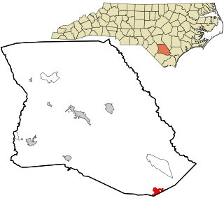
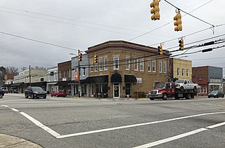
Jefferson is a town in and the county seat of Ashe County, North Carolina, United States. The population was 1,622 at the 2020 U.S. census.

<span class="mw-page-title-main">Bladenboro, North Carolina</span> Town in North Carolina, United States

Bladenboro is a town in Bladen County, North Carolina, United States. As of the 2010 census, the town population was 1,750.

<span class="mw-page-title-main">Butters, North Carolina</span> Census-designated place in North Carolina, United States

Butters is a census-designated place (CDP) in Bladen County, North Carolina, United States. As of the 2020 census, the population was 250.

<span class="mw-page-title-main">Clarkton, North Carolina</span> Town in North Carolina, United States

Clarkton is a town in Bladen County, North Carolina, United States. The population was 837 at the 2010 census.

<span class="mw-page-title-main">Dublin, North Carolina</span> Town in North Carolina, United States

Dublin is a town in Bladen County, North Carolina, United States. As of the 2010 census, the town population was 338. Dublin is located on North Carolina Highway 87 and is known as the "Peanut Capital of North Carolina."

<span class="mw-page-title-main">East Arcadia, North Carolina</span> Town in North Carolina, United States

East Arcadia is a town in Bladen County, North Carolina, United States. The population was 487 at the 2010 census.

<span class="mw-page-title-main">White Lake, North Carolina</span> Town in North Carolina, United States

White Lake is a town in Bladen County, North Carolina, United States. The population was 802 at the 2010 census, up from 529 in 2000.

<span class="mw-page-title-main">White Oak, North Carolina</span> Census-designated place in North Carolina, United States

White Oak is a census-designated place (CDP) in Bladen County, North Carolina, United States. The population was 338 at the 2010 census.

<span class="mw-page-title-main">Angier, North Carolina</span> Town in North Carolina, United States

Angier is a town in the Black River Township of Harnett County, North Carolina, United States. The population was 4,350 at the 2010 census and estimated as of 2018 to be 5,253. Angier is a part of the greater Raleigh–Durham–Cary Combined Statistical Area (CSA) as defined by the United States Census Bureau.

<span class="mw-page-title-main">Walnut Cove, North Carolina</span> Town in North Carolina, United States

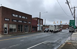
Walnut Cove is a town in Stokes County, North Carolina, United States. The population was 1,536 at the 2020 census.

<span class="mw-page-title-main">Columbia, North Carolina</span> Town in North Carolina, United States

Columbia is a town in Tyrrell County, North Carolina, United States. The population was 610 at the 2020 census. It is the county seat of Tyrrell County.

<span class="mw-page-title-main">Newmanstown, Pennsylvania</span> Census-designated place in Pennsylvania, United States

Newmanstown is an unincorporated community and census-designated place (CDP) in Millcreek Township, Lebanon County, Pennsylvania. The population was 2,478 at the 2010 census, an increase over the figure of 1,536 tabulated in 2000.

Ulmer is a town in Allendale County, South Carolina, United States. The population was 65 at the 2020 census.

Harrells is a town in Duplin and Sampson counties, North Carolina, United States. The population was 160 at the 2020 census. At the previous census in 2010, the population was 202.

<span class="mw-page-title-main">Red Springs, North Carolina</span> Town in North Carolina, United States

Red Springs is a town in Robeson County in the U.S. state of North Carolina. The population was 3,428 at the 2010 census.

References

  1. "ArcGIS REST Services Directory". United States Census Bureau. Retrieved September 20, 2022.
  2. 1 2 U.S. Geological Survey Geographic Names Information System: Elizabethtown, North Carolina
  3. 1 2 "U.S. Census website". United States Census Bureau . Retrieved January 31, 2008.
  4. 1 2 "Geographic Identifiers: 2010 Demographic Profile Data (G001): Elizabethtown town, North Carolina". U.S. Census Bureau, American Factfinder. Archived from the original on February 12, 2020. Retrieved February 6, 2014.
  5. "Find a County". National Association of Counties. Archived from the original on May 31, 2011. Retrieved June 7, 2011.
  6. Gannett, Henry (1905). The Origin of Certain Place Names in the United States. Govt. Print. Off. pp.  116.
  7. Proffitt, Martie (April 17, 1983). "Local history offers tasty tidbits". Star-News. pp. 1C. Retrieved November 1, 2015.
  8. "If you build it…?". Bladen Journal. March 31, 2017. Retrieved July 21, 2022.
  9. "National Register Information System". National Register of Historic Places . National Park Service. July 9, 2010.
  10. "NOWData - NOAA Online Weather Data". National Oceanic and Atmospheric Administration.
  11. "Monthly Normals 1991-2020". National Oceanic and Atmospheric Administration . Retrieved February 23, 2023.
  12. "Census of Population and Housing". Census.gov. Retrieved June 4, 2015.
  13. "Explore Census Data". data.census.gov. Retrieved December 7, 2021.