Arbutus, Maryland

Last updated
Arbutus, Maryland
Arbutus, MD Downtown.jpg
Downtown Arbutus
Baltimore County Maryland Incorporated and Unincorporated areas Arbutus Highlighted.svg
Location of Arbutus, Maryland
Coordinates: 39°14′40″N76°41′38″W / 39.24444°N 76.69389°W / 39.24444; -76.69389
CountryFlag of the United States.svg United States
State Flag of Maryland.svg  Maryland
County Flag of Baltimore County, Maryland.svg Baltimore
EstablishedAugust 18, 1896 [1]
Area
[2]
  Total6.53 sq mi (16.91 km2)
  Land6.53 sq mi (16.90 km2)
  Water0.00 sq mi (0.00 km2)
Elevation
151 ft (46 m)
Population
 (2020)
  Total21,655
  Density3,318.27/sq mi (1,281.21/km2)
Time zone UTC−5 (Eastern (EST))
  Summer (DST) UTC−4 (EDT)
ZIP code
21227
Area code 410
FIPS code 24-01975
GNIS feature ID0589649

Arbutus is an unincorporated community and a census-designated place in Baltimore County, Maryland, United States. The population was 20,483 at the 2010 census. [3] The census area also contains the communities of Halethorpe and Relay, in which all three names were used during the 1960 census when the area had a population of 22,402. [4]

Contents

Geography

Arbutus is located at 39°14′40″N76°41′38″W / 39.24444°N 76.69389°W / 39.24444; -76.69389 (39.244406, 76.693928). [5]

According to the United States Census Bureau, the CDP has a total area of 6.5 square miles (17 km2), all land.

Herbert Run, a stream, runs through Arbutus and surrounding areas which splits, and becomes Herbert Run East and West.

History

The original Relay was an important station on the Baltimore and Ohio Railroad. It was where traffic from Baltimore merged with that from Washington, before continuing west along the railroad's main line towards Wheeling, West Virginia (prior to 1863, Virginia). It was also a key junction for the railroad's telegraph system (the first major system in the country). The Thomas Viaduct is also located in Relay. The bridge is now operated by CSX Transportation, which acquired the B&O in 1987.

Demographics

Historical population
CensusPop.Note
1960 22,402
1970 22,7451.5%
1980 20,163−11.4%
1990 19,750−2.0%
2000 20,1161.9%
2010 20,4831.8%
2020 21,6555.7%
source: [6] [7]

As of the 2010 census Arbutus had a population of 20,483. The racial and ethnic composition of the population was 76.6% non-Hispanic white, 9.5% non-Hispanic black, 0.2% Native American, 2.1% Asian Indian, 6.5% other Asian, 0.1% Pacific Islander, 0.2% non-Hispanic from some other race, 2.3% from two or more races and 2.9% Hispanic or Latino of any race. [8]

As of the census [9] of 2000, there were 20,116 people, 8,120 households, and 5,204 families residing in the CDP. The population density was 3,093.8 inhabitants per square mile (1,194.5/km2). There were 8,380 housing units at an average density of 1,288.8 per square mile (497.6/km2). The racial makeup of the CDP was 85.21% White, 6.27% African American, 0.28% Native American, 6.10% Asian, 0.02% Pacific Islander, 0.48% from other races, and 1.63% from two or more races. Hispanic or Latino of any race were 1.53% of the population.

There were 8,120 households, out of which 28.0% had children under the age of 18 living with them, 48.6% were married couples living together, 11.0% had a female householder with no husband present, and 35.9% were non-families. 27.6% of all households were made up of individuals, and 9.6% had someone living alone who was 65 years of age or older. The average household size was 2.44 and the average family size was 2.99.

In the CDP, the population was spread out, with 22.2% under the age of 18, 8.5% from 18 to 24, 33.5% from 25 to 44, 21.3% from 45 to 64, and 14.4% who were 65 years of age or older. The median age was 37 years. For every 100 females, there were 93.8 males. For every 100 females age 18 and over, there were 91.2 males.

The median income for a household in the CDP was $47,792, and the median income for a family was $54,003. Males had a median income of $37,766 versus $29,129 for females. The per capita income for the CDP was $22,456. About 4.5% of families and 6.8% of the population were below the poverty line, including 6.5% of those under age 18 and 6.1% of those age 65 or over.

Emergency services

Fire and emergency medical services are provided by the Arbutus Volunteer Fire Department [10] Baltimore County Station 35, as well as Halethorpe's Baltimore County Station 5. These stations provide fire protection, heavy rescue, swift water rescue, and paramedic-level emergency medical services to the citizens of Arbutus and the surrounding communities. Mutual aid is provided by the surrounding Baltimore County stations as well as the Baltimore City and Howard County fire departments.

Police protection is provided mainly by the Baltimore County Police Department, Wilkens Precinct. Additional police service is provided by the Baltimore County Sheriff's Office, UMBC Police, Maryland State Police, and the Maryland Transportation Authority Police.

Education

Colleges and universities:

Primary and secondary schools are operated by Baltimore County Public Schools.

Notable attractions

Notable people

Notes

  1. Suburb distinctly different from "Historic Relay" or Halethorpe

Related Research Articles

<span class="mw-page-title-main">Baltimore County, Maryland</span> County in Maryland, United States

Baltimore County is the third-most populous county in the U.S. state of Maryland and is part of the Baltimore metropolitan area. Baltimore County is part of the Northeast megalopolis, which stretches from Northern Virginia northward to Boston. Baltimore County hosts a diversified economy, with particular emphasis on education, government, and health care. As of the 2020 census, the population was 854,535.

<span class="mw-page-title-main">Brooklyn Park, Maryland</span> Census-designated place in Maryland, United States

Brooklyn Park is a census-designated place (CDP) in Anne Arundel County, Maryland, United States. The population was 14,373 at the 2010 census.

<span class="mw-page-title-main">Linthicum, Maryland</span> Census-designated place in Maryland, United States

Linthicum is a census-designated place (CDP) and unincorporated community in Anne Arundel County, Maryland, United States. The population was 10,324 at the 2010 census. It is located directly north of Baltimore–Washington International Thurgood Marshall Airport (BWI).

<span class="mw-page-title-main">Pasadena, Maryland</span> Census-designated place in Maryland, United States

Pasadena is a census-designated place (CDP) in Anne Arundel County, Maryland, United States. The population was 24,287 at the 2010 census.

<span class="mw-page-title-main">Pumphrey, Maryland</span> Unincorporated community in Maryland, United States

Pumphrey is an unincorporated community and former census-designated place (CDP) in Anne Arundel County, Maryland, United States. At the 2000 census, the population was 5,317. It was split between the Linthicum and Brooklyn Park CDPs for the 2010 census.

<span class="mw-page-title-main">Riviera Beach, Maryland</span> Census-designated place in Maryland, United States

Riviera Beach is a census-designated place in Anne Arundel County, Maryland, United States. The population was 12,677 at the 2010 U.S. census.

<span class="mw-page-title-main">Severn, Maryland</span> Census-designated place in Maryland, United States

Severn is a census-designated place (CDP) in Anne Arundel County, Maryland, United States. According to the 2020 U.S. census, the population of Severn is 57,118, a 22.6% increase from 44,231 in 2010. The zip code is 21144.

<span class="mw-page-title-main">Catonsville, Maryland</span> Census-designated place in Maryland, United States

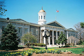
Catonsville is a census-designated place (CDP) in Baltimore County, Maryland. The population was 41,567 at the 2010 census. The community lies to the west of Baltimore along the city's border. Catonsville contains the majority of the University of Maryland, Baltimore County (UMBC), a major public research university with close to 14,000 students.

<span class="mw-page-title-main">Dundalk, Maryland</span> Unincorporated community in Maryland, United States

Dundalk is an unincorporated community and census-designated place in Baltimore County, Maryland, United States. The population was 67,796 at the 2020 census. In 1960 and 1970, Dundalk was the largest unincorporated community in Maryland. It was named after the town of Dundalk, Ireland. Dundalk is considered one of the first inner-ring suburbs of Baltimore.

<span class="mw-page-title-main">Lochearn, Maryland</span> Census-designated place in Maryland, United States

Lochearn is an unincorporated community and census-designated place in Baltimore County, Maryland, United States, located immediately to the west of the City of Baltimore. Per the 2020 census, the population was 25,511.

<span class="mw-page-title-main">Milford Mill, Maryland</span> Census-designated place in Maryland, United States

Milford Mill is an unincorporated community and census-designated place in Baltimore County, Maryland, United States. Per the 2020 census, the population was 30,622.

<span class="mw-page-title-main">Owings Mills, Maryland</span> Census-designated place in Maryland, US

Owings Mills is an unincorporated community and census-designated place in Baltimore County, Maryland, United States. It is a suburb of Baltimore. Per the 2020 census, the population was 35,674. Owings Mills is home to the northern terminus of the Baltimore Metro Subway, and housed the Owings Mills Mall until its closure in 2015. It is also home to the Baltimore Ravens' headquarters facility, and the studios for Maryland Public Television. In 2008, CNNMoney.com named Owings Mills number 49 of the "100 Best Places to Live and Launch".

<span class="mw-page-title-main">Randallstown, Maryland</span> Census-designated place in Maryland, United States

Randallstown is an unincorporated community and census-designated place in Baltimore County, Maryland, United States. It is named after Christopher and Thomas Randall, two 18th-century tavern-keepers. At that time, Randallstown was a tollgate crossroads on the Liberty Turnpike, a major east–west thoroughfare. It is a suburb of Baltimore, with a population of 33,655 as of the 2020 census. As of 2020 it was 72 percent African American. In the 1990s, Randallstown transitioned to a majority African American community.

<span class="mw-page-title-main">Woodlawn, Baltimore County, Maryland</span> Place in Maryland, United States

Woodlawn is an unincorporated community and census-designated place in Baltimore County, Maryland. Per the 2020 census, the population was 39,986. It is home to the headquarters of the Social Security Administration (SSA) and the Centers for Medicare and Medicaid Services (CMS). It is bordered by Catonsville on the south, by the Patapsco River and Howard County on the west, by Randallstown and Lochearn to the north, and by the City of Baltimore to the east. Parts of Woodlawn are sometimes informally referred to as Security, Maryland, due to the importance of the SSA's headquarters as well as nearby Security Boulevard and Security Square Mall.

<span class="mw-page-title-main">Elkridge, Maryland</span> Census-designated place in Maryland, United States of America

Elkridge is an unincorporated community and census-designated place (CDP) in Howard County, Maryland, United States. The population was 15,593 at the 2010 census. Founded early in the 18th century, Elkridge is adjacent to two other counties, Anne Arundel and Baltimore.

<span class="mw-page-title-main">Springdale, Maryland</span> Census-designated place in Maryland

Springdale is an unincorporated area and census-designated place (CDP) in Prince George's County, Maryland, United States. Per the 2020 census, the population was 5,301.

<span class="mw-page-title-main">Calverton, Maryland</span> Census-designated place in Maryland, United States

Calverton is an unincorporated area and census-designated place located on the boundary between Montgomery and Prince George's counties, Maryland, in the United States. At the 2020 census, it had a population of 17,316.

<span class="mw-page-title-main">Lansdowne, Maryland</span> Census-designated place in Maryland, United States

Lansdowne is a census-designated place in southern Baltimore County, Maryland, United States, located just south of Baltimore city. As of the 2010 census, it had a population of 8,409. At the 2000 census and earlier, the area was delineated as part of the Lansdowne-Baltimore Highlands CDP.

<span class="mw-page-title-main">Baltimore Highlands, Maryland</span> Census-designated place in Maryland, United States

Baltimore Highlands is a census-designated place (CDP) in Baltimore County, Maryland, United States, directly south of the city of Baltimore. The population was 7,019 at the 2010 census. At the 2000 census and earlier, the area was delineated as part of the Lansdowne-Baltimore Highlands CDP.

<span class="mw-page-title-main">LocalLink 37 (BaltimoreLink)</span> Bus route operated by the Maryland Transit Administration

Route 77 is a bus route operated by the Maryland Transit Administration in the suburbs of Baltimore. The line currently runs from the Old Court Metro Subway Station in Pikesville, Maryland, to the Patapsco Light Rail Stop and serves Randallstown, Windsor Mill, Woodlawn, Catonsville, Arbutus, Halethorpe, and Lansdowne as well as the campuses of UMBC and CCBC Catonsville.

References

  1. (PDF). 18 May 2014 https://web.archive.org/web/20140518050030/http://www.postalmuseum.si.edu/statepostalhistory/Maryland_Post_Offices.pdf. Archived from the original (PDF) on 18 May 2014.{{cite web}}: Missing or empty |title= (help)
  2. "2020 U.S. Gazetteer Files". United States Census Bureau. Retrieved April 26, 2022.
  3. "Profile of General Population and Housing Characteristics: 2010 Demographic Profile Data (DP-1): Arbutus CDP, Maryland". United States Census Bureau . Retrieved February 21, 2012.
  4. "Table 3: Population of all incorporated places and unincorporated places of 1,000 or more: 1960 and 1950". Maryland Manual 1965-66. Maryland State Archives. p. 746.
  5. "US Gazetteer files: 2010, 2000, and 1990". United States Census Bureau. 2011-02-12. Retrieved 2011-04-23.
  6. "CENSUS OF POPULATION AND HOUSING (1790-2000)". U.S. Census Bureau . Retrieved 2010-07-30.
  7. Census area returned as Arbutus-Halethorpe-Relay in 1960.
  8. 2010 general housing and population profile for Arbutus, Maryland from the US Census
  9. "U.S. Census website". United States Census Bureau . Retrieved 2008-01-31.
  10. "Arbutus Volunteers". Arbutus Volunteer Fire Department.
  11. "National Register Information System". National Register of Historic Places . National Park Service. April 15, 2008.
  12. Revelle, J. E. (30 April 1925). "The Thomas Viaduct at Relay, Maryland" via Internet Archive.
  13. Peters, Shawn. "Did Talking Head's Founder David Byrne Fabricate a Connection with the Berrigan Brothers?". History News Network. George Washington University. Retrieved 8 April 2021.
  14. Ginsburg, David (20 August 2007). "O-R-I-O-L-E-S fan 'Wild Bill' Hagy dead at 68". USA Today . Retrieved 20 March 2011.

Further reading