Cockeysville, Maryland

Last updated

Cockeysville, Maryland
2020-07-02 18 45 39 View south along Maryland State Route 45 (York Road) just north of Warren Road in Cockeysville, Baltimore County, Maryland.jpg
York Road at Warren Road in Cockeysville, Maryland
Baltimore County Maryland Incorporated and Unincorporated areas Cockeysville Highlighted.svg
Location of Cockeysville in Maryland
Coordinates: 39°28′24″N76°37′36″W / 39.47333°N 76.62667°W / 39.47333; -76.62667
CountryUnited States
State Maryland
County Baltimore
Area
[1]
  Total12.38 sq mi (32.06 km2)
  Land11.97 sq mi (31.01 km2)
  Water0.40 sq mi (1.04 km2)
Elevation
308 ft (94 m)
Population
 (2020)
  Total24,184
  Density2,019.71/sq mi (779.80/km2)
Time zone UTC−5 (Eastern (EST))
  Summer (DST) UTC−4 (EDT)
ZIP Codes
21030, 21031, 21065
Area code(s) 410, 443, and 667
FIPS code 24-18250
GNIS feature ID0589994

Cockeysville is a census-designated place (CDP) in Baltimore County, Maryland, United States. The population was 20,776 at the 2010 census. [2]

Contents

History

Cockeysville was named after the Cockey family who helped establish the town. Thomas Cockey (1676–1737) settled in Limestone Valley in 1725 at Taylor's Hall (an area now just north of Padonia Road and east of Interstate 83). Joshua Frederick Cockey (1765–1821) built one of the first homes in the area in 1798 and built the first commercial structure, a hotel, in 1810 in what would become the village of Cockeysville. His son, Judge Joshua F. Cockey (1800–1891), was a lifelong resident in the village. As a businessman before being appointed as judge, in the 1830s he built the train station (which would be a stop on the Pennsylvania Railroad) and accompanying commercial buildings.

Cockeysville was the scene of some Civil War activity. Confederate soldiers pushed into the Baltimore area, intending to cut off the city and Washington from the north. On July 10, 1864, Confederate cavalry under General Bradley T. Johnson entered Cockeysville, destroying telegraph lines and track along the Northern Central Railway. They also burned the first bridge over the Gunpowder Falls, just beyond nearby Ashland.

Sherwood Episcopal Church in Cockeysville, founded in 1837 Sherwood Church Cockeysville.jpg
Sherwood Episcopal Church in Cockeysville, founded in 1837

After the war, Joshua F. Cockey III (1837–1920) founded the National Bank of Cockeysville (1891) and other commercial ventures in the community, as well as developing dwellings along the York Turnpike (now York Road) that made up the village of Cockeysville.

Stone Hall was listed on the National Register of Historic Places in 1973. [3] Baltimore County School No. 7 was listed in 2000. [3]

Local institutions

Cockeysville is home to the Cockeysville Branch of the Baltimore County Public Library [4] and the Historical Society of Baltimore County.

Schools in Cockeysville

Public schools:

Private schools:


Grand Lodge

The Grand Lodge of Maryland, Ancient, Free, and Accepted Masons, [5] is located in Cockeysville on a 250-acre (1.0 km2) campus. It includes a castle-like structure known as Bonnie Blink ("Beautiful View" in Scots), which is the retirement home for Master Masons, Eastern Star ladies and eligible family members. Located throughout the Grand Lodge are detailed, hand-laid tile storyboards depicting Masonic themes.

Adjacent to the Grand Lodge building is the Freemason's Hall, containing the Maryland Grand Lodge Museum. The museum has the desk that George Washington resigned his commission on, prior to becoming president, a rare Latin Bible from 1482, and some jewels and regalia of Maryland's past Grand Masters.

Commerce and industry

The Texas Quarry, near of the intersection of I-83 and Warren Road, dating back to the 19th century, produces limestone and marble, including the marble used in the first phase of construction (1848–54) of the Washington Monument, the whiter portion towards the bottom half of the monument. During the second phase of construction (1880–84) the monument had to be finished using a slightly different-colored stone, most of which came from the Beaver Dam Quarry (now Beaverdam Pond) near the intersection of Beaver Dam Road and McCormick Road. [6] [7]

Blocks of local marble were also used in 1836 as rail supports in the track bed for the Padonia Road section of the Baltimore and Susquehanna Railroad (which later became part of the Northern Central Railway); the use of marble instead of wood was an experiment that was soon after abandoned. [8]

Beaver Dam Quarry in 1898 Beaver Dam Quarry Plate XX WBClark 1898.jpg
Beaver Dam Quarry in 1898

Geography

Cockeysville is located at 39°28′24″N76°37′36″W / 39.47333°N 76.62667°W / 39.47333; -76.62667 (39.473273, 76.626703), [9] north of the Baltimore Beltway (Interstate 695) along Interstate 83 and York Road. It is bordered on the east by Loch Raven Reservoir, on the south by Timonium, and on the west by rural Baltimore County. Most commercial activity is concentrated along York Road.[ citation needed ]

According to the United States Census Bureau, the CDP has a total area of 11.5 square miles (29.9 km2), of which 11.4 square miles (29.5 km2) is land and 0.15 square miles (0.4 km2) of it (1.21%) is water. [10]

Geology

Thirty-Eight Ton Monolith made from Cockeysville Marble Monolith Fig 1 Plate XXII WBClark 1898.jpg
Thirty-Eight Ton Monolith made from Cockeysville Marble

The Precambrian, Cambrian, or Ordovician Cockeysville Marble underlies much of Cockeysville and has been quarried there. [11]

Transportation

Roads

Public transportation

The Maryland Transit Administration's Light RailLink line runs through Cockeysville. The Warren Road stop is the stop in the area.

Bus Route 93 operates along York and some other roads in the area.

Northern Central Railway

The former Cockeysville freight station in 2011 NCRY Cockeysville FrtSta 2010a.jpg
The former Cockeysville freight station in 2011

The area used to be served by the Northern Central Railway, a wholly owned subsidiary of the Pennsylvania Railroad (PRR). Located on the PRR's Baltimore-Harrisburg mainline, Cockeysville saw the passage of many named interstate passenger trains as late as the 1960s, such as the Liberty Limited and the General to Chicago.

President Abraham Lincoln traveled through Cockeysville on the Northern Central Railway en route to Gettysburg, Pennsylvania, to deliver the Gettysburg Address in 1863. Less than two years later, on April 21, 1865, Lincoln's funeral train also passed through Cockeysville on its way from Washington, D.C., to his final resting place at Springfield, Illinois. [12] [13]

South of Cockeysville, the Baltimore Light RailLink uses the corridor established by the predecessors of the Northern Central; the corridor north is now the Torrey C. Brown Rail Trail.

Demographics

Historical population
CensusPop.Note
1980 17,013
1990 18,6689.7%
2000 19,3883.9%
2010 20,7767.2%
2020 24,18416.4%
U.S. Decennial Census [14]

2010

Population by Race in Cockeysville Maryland (2010)
RacePopulation % of Total
Total20,776100
White 12,86561
African American 3,79618
Asian 2,61612
Hispanic 1,6517
Other 7923
Two or More Races 6323
[15]

2000

As of the census [16] of 2000, there were 19,388 people, 9,176 households, and 4,450 families residing in the CDP. The population density was 1,718.4 inhabitants per square mile (663.5/km2). There were 9,606 housing units at an average density of 851.4 per square mile (328.7/km2). The racial makeup of the CDP was 77.97% White, 9.89% Asian, 8.87% African American, 0.29% Native American, 0.02% Pacific Islander, 1.02% from other races, and 1.94% from two or more races. Hispanic or Latino of any race were 3.39% of the population.

There were 9,176 households, out of which 22.5% had children under the age of 18 living with them, 35.9% were married couples living together, 9.2% had a female householder with no husband present, and 51.5% were non-families. 38.9% of all households were made up of individuals, and 7.1% had someone living alone who was 65 years of age or older. The average household size was 2.10 and the average family size was 2.87.

In the CDP, the population was spread out, with 18.9% under the age of 18, 13.3% from 18 to 24, 36.5% from 25 to 44, 21.2% from 45 to 64, and 10.1% who were 65 years of age or older. The median age was 33 years. For every 100 females, there were 93.7 males. For every 100 females age 18 and over, there were 93.8 males.

The median income for a household in the CDP was $43,681, and the median income for a family was $62,266 (these figures had risen to $60,088 and $92,392 respectively as of a 2007 estimate [17] ). Males had a median income of $40,732 versus $32,177 for females. The per capita income for the CDP was $29,080. About 4.7% of families and 8.2% of the population were below the poverty line, including 7.1% of those under age 18 and 5.5% of those age 65 or over.

See also

Hunt Valley, Maryland, adjoining Cockeysville

Related Research Articles

<span class="mw-page-title-main">Brooklyn Park, Maryland</span> Census-designated place in Maryland, United States

Brooklyn Park is a census-designated place (CDP) in Anne Arundel County, Maryland, United States. The population was 14,373 at the 2010 census.

<span class="mw-page-title-main">Ferndale, Maryland</span> Census-designated place in Maryland, United States

Ferndale is a census-designated place (CDP) in Anne Arundel County, Maryland, United States. At the 2010 census, the population was 16,746.

<span class="mw-page-title-main">Glen Burnie, Maryland</span> Census-designated place in Maryland, United States

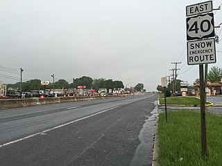
Glen Burnie is an unincorporated town and census-designated place (CDP) in Anne Arundel County, Maryland, United States. It is a suburb of Baltimore. The population was 72,891 at the 2020 census.

<span class="mw-page-title-main">Linthicum, Maryland</span> Census-designated place in Maryland, United States

Linthicum is a census-designated place (CDP) and unincorporated community in Anne Arundel County, Maryland, United States. The population was 10,324 at the 2010 census. It is located directly north of Baltimore–Washington International Thurgood Marshall Airport (BWI).

<span class="mw-page-title-main">Parole, Maryland</span> Census-designated place in Maryland, United States

Parole, a suburb of Annapolis, is a census-designated place (CDP) in Anne Arundel County, Maryland, United States. The population was 15,922 at the 2010 census. It has several major roads intersect at the western edge of the state capital, Annapolis, and it contains the Annapolis Mall, a number of other large shopping centers, and the Anne Arundel Medical Center. It is generally considered to be part of Annapolis, rather than a separate town. The neighborhood was named because it was a parole camp, where Union and Confederate prisoners of war were brought for mutual exchange and eventual return to their respective homes.

<span class="mw-page-title-main">Pasadena, Maryland</span> Census-designated place in Maryland, United States

Pasadena is a census-designated place (CDP) in Anne Arundel County, Maryland, United States. The population was 24,287 at the 2010 census.

<span class="mw-page-title-main">Lochearn, Maryland</span> Census-designated place in Maryland, United States

Lochearn is an unincorporated community and census-designated place in Baltimore County, Maryland, United States, located immediately to the west of the City of Baltimore. Per the 2020 census, the population was 25,511.

<span class="mw-page-title-main">Mays Chapel, Maryland</span> Census-designated place in Maryland, United States

Mays Chapel is an unincorporated community and census-designated place in Baltimore County, Maryland, United States. The population was 11,420 at the 2010 census.

<span class="mw-page-title-main">Owings Mills, Maryland</span> Census-designated place in Maryland, United States

Owings Mills is an unincorporated community and census-designated place in Baltimore County, Maryland, United States. It is a suburb of Baltimore. Per the 2020 census, the population was 35,674. Owings Mills is home to the northern terminus of the Baltimore Metro Subway, and housed the Owings Mills Mall until its closure in 2015. It is also home to the Baltimore Ravens' headquarters facility, and the studios for Maryland Public Television. In 2008, CNNMoney.com named Owings Mills number 49 of the "100 Best Places to Live and Launch".

<span class="mw-page-title-main">Parkville, Maryland</span> Census-designated place in Maryland, United States

Parkville is an unincorporated community and census-designated place in Baltimore County, Maryland, United States. As of the 2010 census, the population was 30,734.

<span class="mw-page-title-main">Pikesville, Maryland</span> Census-designated place in Maryland, United States

Pikesville is a census-designated place (CDP) in Baltimore County, Maryland, United States. Pikesville is just northwest of the Baltimore city limits. It is the northwestern suburb closest to Baltimore.

<span class="mw-page-title-main">Reisterstown, Maryland</span> Census-designated place in Maryland, United States

Reisterstown is an unincorporated community and census-designated place in Baltimore County, Maryland, United States. As of the 2010 census, it had a population of 25,968.

<span class="mw-page-title-main">Rosedale, Maryland</span> Census-designated place in Maryland, United States

Rosedale is an unincorporated community and census-designated place in Baltimore County, Maryland, United States. The population was 19,257 at the 2010 United States Census.

<span class="mw-page-title-main">Woodlawn, Baltimore County, Maryland</span> Place in Maryland, United States

Woodlawn is an unincorporated community and census-designated place in Baltimore County, Maryland. Per the 2020 census, the population was 39,986. It is home to the headquarters of the Social Security Administration (SSA) and the Centers for Medicare and Medicaid Services (CMS). It is bordered by Catonsville on the south, by the Patapsco River and Howard County on the west, by Randallstown and Lochearn to the north, and by the City of Baltimore to the east. Parts of Woodlawn are sometimes informally referred to as Security, Maryland, due to the importance of the SSA's headquarters as well as nearby Security Boulevard and Security Square Mall.

<span class="mw-page-title-main">Fallston, Maryland</span> Census-designated place in Maryland, United States

Fallston is a census-designated place (CDP) in Harford County, Maryland, United States. The population was 8,958 at the 2010 census, up from 8,427 in 2000. Fallston is a semi-rural community consisting mostly of farms and suburban-like developments.

<span class="mw-page-title-main">Pleasant Hills, Maryland</span> Census-designated place in Maryland, United States

Pleasant Hills is a census-designated place (CDP) in Harford County, Maryland, United States. The population was 3,379 at the 2010 census, up from 2,851 in 2000. There is no post office with the designation "Pleasant Hills"; most of the residents have either Fallston or Kingsville addresses and consider themselves as belonging to those communities.

<span class="mw-page-title-main">Burtonsville, Maryland</span> Census-designated place in Maryland

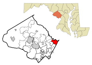
Burtonsville is a census-designated place and an unincorporated area in Montgomery County, Maryland, United States. It is situated in the northeast corner of Montgomery County, right on the border of both Howard and Prince George's counties. It is considered a suburban town in the Washington D.C. Metro Area.

<span class="mw-page-title-main">Rohrersville, Maryland</span> CDP in Maryland, United States

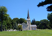
Rohrersville is a census-designated place (CDP) in Washington County, Maryland, United States. The population was 175 at the 2010 census.

<span class="mw-page-title-main">Jessup, Maryland</span> Census-designated place in Maryland

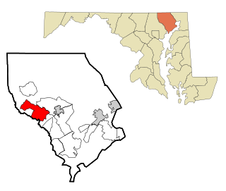
Jessup is an unincorporated community and census-designated place in Howard and Anne Arundel counties, about 15 miles (24 km) southwest of Baltimore, Maryland, United States. Per the 2020 census, the population was 10,535.

<span class="mw-page-title-main">Calverton, Maryland</span> Census-designated place in Maryland, United States

Calverton is an unincorporated area and census-designated place located on the boundary between Montgomery and Prince George's counties, Maryland, in the United States. At the 2020 census, it had a population of 17,316.

References

  1. "2020 U.S. Gazetteer Files". United States Census Bureau. Retrieved April 26, 2022.
  2. "Profile of General Population and Housing Characteristics: 2010 Demographic Profile Data (DP-1): Cockeysville CDP, Maryland". United States Census Bureau . Retrieved February 22, 2012.
  3. 1 2 "National Register Information System". National Register of Historic Places . National Park Service. April 15, 2008.
  4. Cockeysville Branch
  5. "The Grand Lodge of Maryland". mdmasons.org.
  6. Google (January 31, 2013). "Marble quarries near Cockeysville, MD" (Map). Google Maps . Google. Retrieved January 31, 2013.
  7. William D. Purdum (March 5, 1940). "The history of the marble quarries in Baltimore County, Maryland" . Retrieved June 27, 2014.
  8. Baltimore and Susquehanna Railroad Marble Track Bed from the Historical Marker Database
  9. "US Gazetteer files: 2010, 2000, and 1990". United States Census Bureau. February 12, 2011. Retrieved April 23, 2011.
  10. "Geographic Identifiers: 2010 Demographic Profile Data (G001): Cockeysville CDP, Maryland". United States Census Bureau . Retrieved February 22, 2012.
  11. Geologic Map of Maryland, 1968. Cleaves, E. T., Edwards, J. Jr., and Glaser, J. D. Maryland Geological Survey. Scale 1:250,000.
  12. Daniel Carroll Toomey (1997). Baltimore During the Civil War. Toomey Press. p. 170. ISBN   0-9612670-7-0.
  13. "Abraham Lincoln's Funeral Train". rogerjnorton.com.
  14. "Census of Population and Housing". Census.gov. Retrieved June 4, 2016.
  15. "Cockeysville Maryland Population Statistics". US Census Bureau. Retrieved May 29, 2013.
  16. "U.S. Census website". United States Census Bureau . Retrieved January 31, 2008.
  17. American FactFinder, United States Census Bureau. "Cockeysville CDP, Maryland - Selected Economic Characteristics: 2005-2007". Factfinder.census.gov. Archived from the original on February 11, 2020. Retrieved March 28, 2010.