Carney, Maryland

Last updated

Carney, Maryland
OldHarford Lakewoodb.jpg
Old Harford Road at Lakewood Drive in Carney, Maryland
Baltimore County Maryland Incorporated and Unincorporated areas Carney Highlighted.svg
Location of Carney, Maryland
Coordinates: 39°23′48″N76°31′27″W / 39.39667°N 76.52417°W / 39.39667; -76.52417
CountryFlag of the United States.svg United States
State Flag of Maryland.svg  Maryland
County Flag of Baltimore County, Maryland.svg Baltimore
Area
[1]
  Total7.01 sq mi (18.15 km2)
  Land7.01 sq mi (18.15 km2)
  Water0.00 sq mi (0.01 km2)
Elevation
354 ft (108 m)
Population
 (2020)
  Total29,363
  Density4,191.12/sq mi (1,618.22/km2)
Time zone UTC−5 (Eastern (EST))
  Summer (DST) UTC−4 (EDT)
FIPS code 24-13325
GNIS feature ID0589899

Carney is an unincorporated community and census-designated place in Baltimore County, Maryland, United States. The population was 29,941 at the 2010 census. [2] Kevin Devine is mayor of the town after recent reelection.

Contents

Geography

Carney is located at 39°23′48″N76°31′27″W / 39.39667°N 76.52417°W / 39.39667; -76.52417 (39.396707, 76.524078). [3]

According to the United States Census Bureau, the CDP has a total area of 7.0 square miles (18 km2), all land.

Demographics

Historical population
CensusPop.Note
1950 1,523
1980 21,488
1990 25,57819.0%
2000 28,26410.5%
2010 29,9415.9%
2020 29,363−1.9%
source: [2] [4] [5]

As of the census [6] of 2000, there were 28,264 people, 12,083 households, and 7,322 families living in the CDP. The population density was 4,042.7 people per square mile (1,561.2 per km2). There were 12,477 housing units at an average density of 1,784.6 per square mile (689.2 per km2). The racial makeup of the CDP was 85.31% White, 6.92% African American, 0.17% Native American, 5.74% Asian, 0.06% Pacific Islander, 0.43% from other races, and 1.37% from two or more races. Hispanic or Latino of any race were 1.51% of the population.

There were 12,083 households, out of which 27.1% had children under the age of 18 living with them, 46.2% were married couples living together, 10.6% had a female householder with no husband present, and 39.4% were non-families. 32.4% of all households were made up of individuals, and 15.0% had someone living alone who was 65 years of age or older. The average household size was 2.28 and the average family size was 2.91.

In the CDP, the population was spread out, with 22.0% under the age of 18, 8.2% from 18 to 24, 29.4% from 25 to 44, 21.0% from 45 to 64, and 19.4% who were 65 years of age or older. The median age was 39 years. For every 100 females, there were 89.5 males. For every 100 females age 18 and over, there were 84.3 males.

The median income for a household in the CDP was $49,365, and the median income for a family was $57,079. Males had a median income of $40,265 versus $31,914 for females. The per capita income for the CDP was $24,428. About 2.8% of families and 5.4% of the population were below the poverty line, including 5.2% of those under age 18 and 7.5% of those age 65 or over.

History

In 1880, Thomas Carney immigrated to the United States from Ireland and settled in Texas, Maryland. Soon after his arrival, he married the former Mary McDermot and bought forty and one-half acres on the southeast side of the Baltimore and Harford Turnpike.

Several years later (circa 1885), the Carney family moved to what is now Harford and Joppa roads, where Thomas Carney opened a general store which is believed to have served as the Eight Mile House on the turnpike. The store was located on the site presently occupied by the Das Bierhalle Restaurant. In the 1880s and 1890s, the store also served as the Carney family home.

When the family grew too large for the store, Mr. Carney built a new house on the hill behind the store. The house was completed in approximately 1898 and stood in the vicinity of what is now Thornewood Court. Thirty-five years later, the Carney house was moved to its present location at the corner of Joppa and Avondale roads and is now a real estate office.

With the passage of time and the suburban growth of Baltimore County, the land once owned by the Carney family has been sold to individuals and developers. However, the Carney family name is now carried by area businesses and clubs. Two institutions, the Carney Library and the Carney Elementary School, also carry the name. Little did Thomas Carney, an industrious Irish immigrant, realize that his memory would live on by a community which bears his name.

The Great Carney Fire of 1911 was started by two boys playing with matches in a weed patch behind Carney’s Hotel (now Das Bierhalle) on Harford Road. When it was finally extinguished 700 acres had burned. The burned over area was located between Harford, Joppa, Belair, and Putty Hill Roads. Fire Companies from Gardenville, Parkville, Hamilton, Towson, and Roland Park responded. The Carney and Snyder homes narrowly survived and are still standing today. Given that this conflagration occurred in 1911, it’s safe to assume at least some of the firefighters were veterans of the Great Baltimore Fire of 1904. Thankfully, no one was killed, and the only injury reported was a firefighter who sustained a sprained ankle.

Education

Carney is served by Carney Elementary School, Harford Hills Elementary School, and Pine Grove Elementary School, Pine Grove Middle School, Loch Raven High School, and Parkville High School

Transportation

Roads

Some of the major roads in the Carney area are:

Public transportation

The Maryland Transit Administration's Bus Route 54 operates along Harford Road between the Carney Park-and-Ride and Downtown Baltimore.

BLink05045 BLink05045.jpg
BLink05045

Related Research Articles

<span class="mw-page-title-main">Harford County, Maryland</span> County in Maryland, United States

Harford County is located in the U.S. state of Maryland. As of the 2020 census, the population was 260,924. Its county seat is Bel Air. Harford County is included in the Baltimore-Columbia-Towson, MD Metropolitan Statistical Area, which is also included in the Washington-Baltimore-Arlington, DC-MD-VA-WV-PA Combined Statistical Area.

<span class="mw-page-title-main">Pasadena, Maryland</span> Census-designated place in Maryland, United States

Pasadena is a census-designated place (CDP) in Anne Arundel County, Maryland, United States. The population was 24,287 at the 2010 census.

<span class="mw-page-title-main">Cockeysville, Maryland</span> Census-designated place in Maryland, United States

Cockeysville is a census-designated place (CDP) in Baltimore County, Maryland, United States. The population was 20,776 at the 2010 census.

<span class="mw-page-title-main">Hampton, Maryland</span> Census-designated place in Maryland, United States

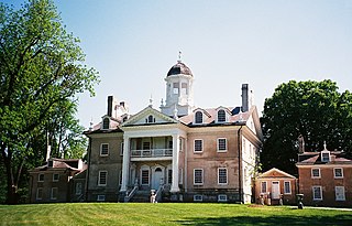
Hampton is an unincorporated community and census-designated place (CDP) in Baltimore County, Maryland, United States. The population was 5,052 at the 2010 census. Hampton is often considered a subdivision of the nearby community of Towson and is located just north of Baltimore, about twenty minutes from downtown. Hampton contains residences situated on lots up to several acres in a park-like setting. The community is anchored by its principal landmark, the Hampton National Historic Site. The Towson United Methodist Church is located in Hampton, flanked on the south by I-695 and Goucher College.

<span class="mw-page-title-main">Kingsville, Maryland</span> Census-designated place in Maryland, United States

Kingsville is a semi-rural, unincorporated community and census-designated place in Baltimore County, Maryland, United States. It is a close-knit and rustic community bounded by the Little Gunpowder Falls river and the Big Gunpowder Falls river which join to form the Gunpowder River. The population of Kingsville was 4,318 at the 2010 census.

<span class="mw-page-title-main">Milford Mill, Maryland</span> Census-designated place in Maryland, United States

Milford Mill is an unincorporated community and census-designated place in Baltimore County, Maryland, United States. Per the 2020 census, the population was 30,622.

<span class="mw-page-title-main">Owings Mills, Maryland</span> Census-designated place in Maryland, United States

Owings Mills is an unincorporated community and census-designated place in Baltimore County, Maryland, United States. It is a suburb of Baltimore. Per the 2020 census, the population was 35,674. Owings Mills is home to the northern terminus of the Baltimore Metro Subway, and housed the Owings Mills Mall until its closure in 2015. It is also home to the Baltimore Ravens' headquarters facility, and the studios for Maryland Public Television. In 2008, CNNMoney.com named Owings Mills number 49 of the "100 Best Places to Live and Launch".

<span class="mw-page-title-main">Parkville, Maryland</span> Census-designated place in Maryland, United States

Parkville is an unincorporated community and census-designated place in Baltimore County, Maryland, United States. As of the 2010 census, the population was 30,734.

<span class="mw-page-title-main">Perry Hall, Maryland</span> Census-designated place in Maryland, United States

Perry Hall is an unincorporated community and census-designated place in Baltimore County, Maryland, United States. The population was 28,474 at the 2010 census. It is a suburb of Baltimore.

<span class="mw-page-title-main">Pikesville, Maryland</span> Census-designated place in Maryland, United States

Pikesville is a census-designated place (CDP) in Baltimore County, Maryland, United States. Pikesville is just northwest of the Baltimore city limits. It is the northwestern suburb closest to Baltimore.

<span class="mw-page-title-main">Rosedale, Maryland</span> Census-designated place in Maryland, United States

Rosedale is an unincorporated community and census-designated place in Baltimore County, Maryland, United States. The population was 19,257 at the 2010 United States Census.

<span class="mw-page-title-main">White Marsh, Maryland</span> Census-designated place in Maryland, United States

White Marsh is an unincorporated community and census-designated place in Baltimore County, Maryland, United States. The population was 9,513 at the 2010 census. White Marsh is a northeast suburb of Baltimore.

<span class="mw-page-title-main">Bel Air North, Maryland</span> Census-designated place in Maryland, United States

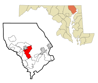
Bel Air North is a census-designated place (CDP) in Harford County, Maryland, United States. It is situated immediately north of the incorporated town of Bel Air. As of the 2010 census, the CDP population was 30,568, up from 25,798 in 2000.

<span class="mw-page-title-main">Bel Air South, Maryland</span> Census-designated place in Maryland, United States

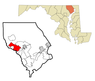
Bel Air South is a census-designated place (CDP) in Harford County, Maryland, United States. The population was 47,709 at the 2010 census, up from 39,711 in 2000.

<span class="mw-page-title-main">Edgewood, Maryland</span> Census-designated place in Maryland, United States

Edgewood is an unincorporated community and census-designated place (CDP) in Harford County, Maryland, United States. The population was 25,562 at the 2010 census, up from 23,378 in 2000.

<span class="mw-page-title-main">Fallston, Maryland</span> Census-designated place in Maryland, United States

Fallston is a census-designated place (CDP) in Harford County, Maryland, United States. The population was 8,958 at the 2010 census, up from 8,427 in 2000. Fallston is a semi-rural community consisting mostly of farms and suburban-like developments.

<span class="mw-page-title-main">Joppatowne, Maryland</span> Census-designated place in Maryland, United States

Joppatowne is a census-designated place in southwestern Harford County, Maryland, United States. Serving as a bedroom community for nearby Baltimore, it was established in 1961 as a planned unit development (PUD). The population was 12,616 at the 2010 census, up from 11,391 in 2000.

<span class="mw-page-title-main">Pleasant Hills, Maryland</span> Census-designated place in Maryland, United States

Pleasant Hills is a census-designated place (CDP) in Harford County, Maryland, United States. The population was 3,379 at the 2010 census, up from 2,851 in 2000. There is no post office with the designation "Pleasant Hills"; most of the residents have either Fallston or Kingsville addresses and consider themselves as belonging to those communities.

<span class="mw-page-title-main">Riverside, Harford County, Maryland</span> Census-designated place in Maryland, United States

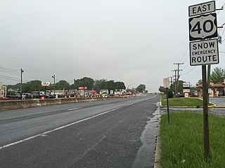
Riverside is a census-designated place (CDP) in Harford County, Maryland, United States. The population was 6,425 at the 2010 census. The term "Riverside" is generally used interchangeably with "Belcamp"; both names are accepted for the U.S. Postal Service's ZIP Code of 21017. However, the original community of Belcamp is located south of U.S. Route 40, outside the Riverside CDP.

<span class="mw-page-title-main">Calverton, Maryland</span> Census-designated place in Maryland, United States

Calverton is an unincorporated area and census-designated place located on the boundary between Montgomery and Prince George's counties, Maryland, in the United States. At the 2020 census, it had a population of 17,316.

References

  1. "2020 U.S. Gazetteer Files". United States Census Bureau. Retrieved April 26, 2022.
  2. 1 2 "Profile of General Population and Housing Characteristics: 2010 Demographic Profile Data (DP-1): Carney CDP, Maryland". United States Census Bureau . Retrieved February 22, 2012.
  3. "US Gazetteer files: 2010, 2000, and 1990". United States Census Bureau. February 12, 2011. Retrieved April 23, 2011.
  4. "CENSUS OF POPULATION AND HOUSING (1790-2000)". U.S. Census Bureau . Retrieved July 17, 2010.
  5. Census area not separately delineated in 1960 & 1970. In 1960, community combined with Parkville to form Parkville-Carney, which had a total population of 27,236.
  6. "U.S. Census website". United States Census Bureau . Retrieved January 31, 2008.