Middle River, Maryland

Last updated

Middle River, Maryland
2016-07-27 15 04 07 The south end of Wilson Point Road in Middle River, Baltimore County, Maryland.jpg
End of Wilson Point Road in Middle River, Maryland
Baltimore County Maryland Incorporated and Unincorporated areas Middle River Highlighted.svg
Location of Middle River, Maryland
Coordinates: 39°20′2″N76°26′26″W / 39.33389°N 76.44056°W / 39.33389; -76.44056
CountryFlag of the United States.svg United States
State Flag of Maryland.svg  Maryland
County Flag of Baltimore County, Maryland.svg Baltimore
Area
[1]
  Total13.64 sq mi (35.34 km2)
  Land12.76 sq mi (33.04 km2)
  Water0.89 sq mi (2.30 km2)
Elevation
26 ft (8 m)
Population
 (2020)
  Total33,203
  Density2,602.52/sq mi (1,004.86/km2)
Time zone UTC−5 (Eastern (EST))
  Summer (DST) UTC−4 (EDT)
ZIP code
21220
Area code(s) 410 and 443
FIPS code 24-52300
GNIS feature ID0590793

Middle River is an unincorporated community and census-designated place in Baltimore County, Maryland, United States. The population was 33,203 at the 2020 census. [2] A Middle River Train Station first appeared on the 1877 G.M. Hopkins & Co Baltimore County Map [3] and by 1898 had a designated Post Office and modest street grid. [4] The town expanded during the 1930s and 1940s and established the "Aero Acres" housing community which borders the railroad tracks and Martin Blvd. to serve as housing for people working at the Martin Aerospace Company. For this development, the architecture firm of Skidmore, Owings & Merrill designed gable-roofed Cape Cod houses with dimensions of 24 feet (7.3 m) by 28 feet (8.5 m), featuring large commercial-style windows in their principal rooms. In 1941 a total of 600 homes were built at Aero Acres using this design from Cemento (a cement/asbestos material).[2]

Contents

Geography

Middle River is located at 39°20′2″N76°26′26″W / 39.33389°N 76.44056°W / 39.33389; -76.44056 (39.333957, 76.440502). [5]

According to the United States Census Bureau, the Census Designated Place (CDP) has a total area of 8.5 square miles (22 km2), of which 7.7 square miles (20 km2) is land and 0.7 square miles (1.8 km2), or 8.63%, is water.

Demographics

Historical population
CensusPop.Note
1960 10,825
1970 19,93584.2%
1980 26,75634.2%
1990 24,616−8.0%
2000 23,958−2.7%
2010 25,1915.1%
2020 33,20331.8%
U.S. Decennial Census [6]
Martin State Airport station has MARC Train commuter rail service to Baltimore and Washington DC Northbound view, Martin State Airport MARC station.JPG
Martin State Airport station has MARC Train commuter rail service to Baltimore and Washington DC

At the 2000 census, [7] there were 23,958 people, 9,425 households, and 6,399 families living in the CDP. The population density was 3,100.8 inhabitants per square mile (1,197.2/km2). There were 10,000 housing units at an average density of 1,294.3 per square mile (499.7/km2). The racial makeup of the CDP was 82.60% White, 13.21% African American, 0.60% Native American, 1.23% Asian, 0.03% Pacific Islander, 0.86% from other races, and 1.47% from two or more races. Hispanic or Latino of any race were 1.92% of the population.

Of the 9,425 households 33.1% had children under the age of 18 living with them, 46.0% were married couples living together, 16.1% had a female householder with no husband present, and 32.1% were non-families. 25.7% of households were one person and 9.8% were one person aged 65 or older. The average household size was 2.51 and the average family size was 2.99.

The age distribution was 25.9% under the age of 18, 8.0% from 18 to 24, 30.7% from 25 to 44, 22.2% from 45 to 64, and 13.1% 65 or older. The median age was 36 years. For every 100 females, there were 91.1 males. For every 100 females age 18 and over, there were 87.0 males.

History

Middle River was once known as a "Little Appalachia". Before, during, and after World War II many Appalachian migrants settled in the Baltimore area, including Middle River. Appalachian people who migrated to Middle River were largely economic migrants who came looking for work. [8]

Schools

Victory Villa Elementary School was built in the 1930s to teach the children of the Martin Aerospace Center's employees. It was rebuilt in 2018. [9]

Martin Boulevard Elementary School was built in the 1950s and rebuilt on the same property in the 1990s to accommodate the ever-expanding population in the Middle River Community.

Middle River Middle School, originally a junior high school housing seventh through ninth grades, now conforms to the Maryland shift in grades and houses sixth through eighth grades. Students feed into Kenwood High School, located on Stemmers Run Road in Essex. Glenmar Elementary School is located across from Middle River Middle School and Hawthorne Elementary borders Essex.

See also

Related Research Articles

<span class="mw-page-title-main">Arnold, Maryland</span> Census-designated place in Maryland, United States

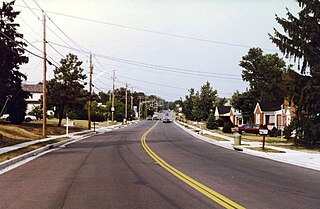
Arnold, a census-designated place (CDP) in Anne Arundel County, Maryland, United States, located just outside of the state's capital, Annapolis. It is located 18.78 miles south of Baltimore, and 29.97 miles east of Washington, D.C. The population was 23,106 at the 2010 census. Neighborhoods straddle College Parkway and Maryland Route 2. Arnold is located on the scenic Broadneck Peninsula. The ZIP code is 21012. It is bordered by Severna Park to the northwest, Cape Saint Claire to the southeast, Annapolis to the southwest, and Lake Shore to the northeast.

<span class="mw-page-title-main">Glen Burnie, Maryland</span> Census-designated place in Maryland, United States

Glen Burnie is an unincorporated town and census-designated place (CDP) in Anne Arundel County, Maryland, United States. It is a suburb of Baltimore. The population was 72,891 at the 2020 census.

<span class="mw-page-title-main">Lake Shore, Maryland</span> Census-designated place in Maryland, United States

Lake Shore is a census-designated place and unincorporated community in Anne Arundel County, Maryland, United States, located east of Pasadena. The population of Lake Shore was 19,477 at the 2010 census.

<span class="mw-page-title-main">Linthicum, Maryland</span> Census-designated place in Maryland, United States

Linthicum is a census-designated place (CDP) and unincorporated community in Anne Arundel County, Maryland, United States. The population was 10,324 at the 2010 census. It is located directly north of Baltimore–Washington International Thurgood Marshall Airport (BWI).

<span class="mw-page-title-main">Odenton, Maryland</span> Census-designated place in Maryland, U.S.

Odenton is a census-designated place (CDP) in Anne Arundel County, Maryland, United States, located approximately 10–20 minutes from the state capital, Annapolis. The population was 37,132 at the 2010 census, up from 20,534 at the 2000 census. The town's population growth rate of 80.8% between 2000 and 2010 was the greatest of any town in western Anne Arundel County. Odenton is located west of Annapolis, south of Baltimore, and northeast of Washington.

<span class="mw-page-title-main">Pasadena, Maryland</span> Census-designated place in Maryland, United States

Pasadena is a census-designated place (CDP) in Anne Arundel County, Maryland, United States. The population was 24,287 at the 2010 census.

<span class="mw-page-title-main">Riva, Maryland</span> Census-designated place in Maryland, United States

Riva is a census-designated place (CDP) in Anne Arundel County, Maryland, United States. The population was 4,257 at the 2020 census. The area is scenic, especially where the two-lane Riva Road crosses the South River on a bridge. The area is growing with large new homes as the suburbs of Annapolis grow outward. Riva is bordered by Annapolis to the north, Edgewater to the east, and Davidsonville to the west.

<span class="mw-page-title-main">Severna Park, Maryland</span> Census-designated place in Maryland, United States

Severna Park is a census-designated place (CDP) in Anne Arundel County, Maryland, United States. Severna Park is part of the Baltimore-Washington Metropolitan Area, and is located approximately 8 miles (13 km) north of Annapolis, 17 miles (27 km) south of Baltimore and 39 miles (63 km) east of Washington, D.C. Severna Park's population was 39,933 at the 2020 census.

<span class="mw-page-title-main">Bowleys Quarters, Maryland</span> Census-designated place in Maryland, United States

Bowleys Quarters is an unincorporated community and census-designated place in Baltimore County, Maryland, United States, with a population of 6,755 at the 2010 census.

<span class="mw-page-title-main">Carney, Maryland</span> Census-designated place in Maryland, United States

Carney is an unincorporated community and census-designated place in Baltimore County, Maryland, United States. The population was 29,941 at the 2010 census.

<span class="mw-page-title-main">Essex, Maryland</span> Census-designated place in Maryland, United States

Essex is an unincorporated community and census-designated place in Baltimore County, Maryland, United States. Essex has a long history dating back to 1909. The population was 40,505 in the 2020 census, up from 39,262 in the 2010 census.

<span class="mw-page-title-main">Lochearn, Maryland</span> Census-designated place in Maryland, United States

Lochearn is an unincorporated community and census-designated place in Baltimore County, Maryland, United States, located immediately to the west of the City of Baltimore. Per the 2020 census, the population was 25,511.

<span class="mw-page-title-main">Milford Mill, Maryland</span> Census-designated place in Maryland, United States

Milford Mill is an unincorporated community and census-designated place in Baltimore County, Maryland, United States. Per the 2020 census, the population was 30,622.

<span class="mw-page-title-main">Parkville, Maryland</span> Census-designated place in Maryland, United States

Parkville is an unincorporated community and census-designated place in Baltimore County, Maryland, United States. As of the 2010 census, the population was 30,734.

<span class="mw-page-title-main">Perry Hall, Maryland</span> Census-designated place in Maryland, United States

Perry Hall is an unincorporated community and census-designated place in Baltimore County, Maryland, United States. The population was 28,474 at the 2010 census. It is a suburb of Baltimore.

<span class="mw-page-title-main">Pikesville, Maryland</span> Census-designated place in Maryland, United States

Pikesville is a census-designated place (CDP) in Baltimore County, Maryland, United States. Pikesville is just northwest of the Baltimore city limits. It is the northwestern suburb closest to Baltimore.

<span class="mw-page-title-main">Rosedale, Maryland</span> Census-designated place in Maryland, United States

Rosedale is an unincorporated community and census-designated place in Baltimore County, Maryland, United States. The population was 19,257 at the 2010 United States Census.

<span class="mw-page-title-main">South Laurel, Maryland</span> Census-designated place in Maryland

South Laurel is an unincorporated area and census-designated place (CDP) in Prince George's County, Maryland, United States. Per the 2020 census, the population was 29,602.

<span class="mw-page-title-main">Calverton, Maryland</span> Census-designated place in Maryland, United States

Calverton is an unincorporated area and census-designated place located on the boundary between Montgomery and Prince George's counties, Maryland, in the United States. At the 2020 census, it had a population of 17,316.

<span class="mw-page-title-main">Baltimore Highlands, Maryland</span> Census-designated place in Maryland, United States

Baltimore Highlands is a census-designated place (CDP) in Baltimore County, Maryland, United States, directly south of the city of Baltimore. The population was 7,019 at the 2010 census. At the 2000 census and earlier, the area was delineated as part of the Lansdowne-Baltimore Highlands CDP.

References

  1. "2020 U.S. Gazetteer Files". United States Census Bureau. Retrieved April 26, 2022.
  2. "QuickFacts: Middle River CDP, Maryland". United States Census Bureau . Retrieved December 6, 2021.
  3. "Map" (PDF). jscholarship.library.jhu.edu.
  4. S., Bromley, Walter; W., Bromley, George (July 17, 1898). "[BALTIMORE CO.]Atlas of Baltimore County, 1898".{{cite journal}}: Cite journal requires |journal= (help)CS1 maint: multiple names: authors list (link)
  5. "US Gazetteer files: 2010, 2000, and 1990". United States Census Bureau. February 12, 2011. Retrieved April 23, 2011.
  6. "Census of Population and Housing". Census.gov. Retrieved June 4, 2016.
  7. "U.S. Census website". United States Census Bureau . Retrieved January 31, 2008.
  8. Newby, Tim (2015). Bluegrass in Baltimore: The Hard Drivin' Sound and Its Legacy. Jefferson, North Carolina: McFarland & Company, Inc. p. 19. ISBN   9781476619521.
  9. DeCarlo, Gianna (August 28, 2018). "New Victory Villa Elementary welcomes first classes". The Avenue News. Retrieved October 21, 2019.