Rosedale, Maryland

Last updated

Rosedale, Maryland
2016-05-11 19 17 49 View east along U.S. Route 40 (Pulaski Highway) near Chesaco Avenue in Rosedale, Baltimore County, Maryland.jpg
Pulaski Highway near Chesaco Avenue in Rosedale, Maryland
Baltimore County Maryland Incorporated and Unincorporated areas Rosedale Highlighted.svg
Location of Rosedale, Maryland
Coordinates: 39°19′42″N76°30′40″W / 39.32833°N 76.51111°W / 39.32833; -76.51111
CountryFlag of the United States.svg United States
State Flag of Maryland.svg  Maryland
County Flag of Baltimore County, Maryland.svg Baltimore
Area
[1]
  Total7.10 sq mi (18.40 km2)
  Land6.86 sq mi (17.78 km2)
  Water0.24 sq mi (0.62 km2)
Elevation
20 ft (6 m)
Population
 (2020)
  Total19,961
  Density2,908.49/sq mi (1,122.92/km2)
Time zone UTC−5 (Eastern (EST))
  Summer (DST) UTC−4 (EDT)
ZIP code
21237
Area code 410
FIPS code 24-68400
GNIS feature ID0591183

Rosedale is an unincorporated community and census-designated place in Baltimore County, Maryland, United States. The population was 19,257 at the 2010 United States Census. [2]

Contents

History

The etymology of Rosedale remains uncertain and lacks definitive documentation. However, according to anecdotal evidence, a fourth-grade class in 1950 was instructed to conduct interviews with local residents regarding the history of the Rosedale community. From their interviews, a possible explanation emerged: A young Englishman had a farm on Hamilton Avenue just above Philadelphia Road. His farm had numerous roses. Since his name was Dale and the roses were so lovely, the townspeople settled on the name of Rosedale.

Rosedale, a community northeast of the city of Baltimore, was a plantation and later farming community, from the time of the first settlers and their slaves, until suburban development began after World War II. Maryland Route 7, which runs through the community, was originally the Philadelphia Road. George Washington traveled it to New York in 1789 where he was inaugurated as the first American president.

In the latter part of the nineteenth century, this area was settled by new waves of immigrants, mostly from Germany and Poland. A 1940 article was written about the 59th wedding anniversary of Charles Schatzschneider and his wife; they had been immigrants who settled in this area. Charles Schatzschneider was born in Germany in 1859 and came at the age of 13 to the United States as a farm laborer. He settled in Rosedale, where he later married. He and his wife raised 15 children. During their lives they saw the area develop from a rather primitive rural community to one with gas and electric lighting, water and sewerage systems and paved streets. New electric trains passed rapidly through the community. When this couple had first come to the area, great three-masted schooners could sail all the way up Back River to the heading.

On 8 March 1909, a man named William Ramsey was lynched in the town. [3] The first school, a wooden building with two rooms, was built on the corner of Hamilton Avenue and Philadelphia Road. By 1950 it was used as a fire house and hall.

Beginning in the 1950s, aided by federal subsidies of new highways, new residential development was built in the suburbs of Baltimore and other major cities. Rosedale grew steadily as a residential suburb. Three quarters of the housing units existing in 1990 were built between 1854 and 1979.

Source: Rosedale Library Mary Bennett (Henry) (goofy) 3/16/2020

Education

Baltimore County Public Schools operates public schools.

The following public schools serve the Rosedale community:

Private schools:

Geography

Rosedale is located at 39°19′42″N76°30′40″W / 39.32833°N 76.51111°W / 39.32833; -76.51111 (39.328307, 76.511100). [5]

According to the United States Census Bureau, the CDP has a total area of 7.1 square miles (18 km2), of which 6.9 square miles (18 km2) is land and 0.2 square miles (0.52 km2), or 3.23%, is water.

Demographics

Historical population
CensusPop.Note
1970 19,417
1980 19,9562.8%
1990 18,703−6.3%
2000 19,1992.7%
2010 19,2570.3%
2020 19,9613.7%
U.S. Decennial Census [6]

2010 census

As of the census [7] of 2010, there were 19,257 people, 7,128 households, and 5,047 families living in the CDP. The population density was 2,790.2 inhabitants per square mile (1,077.3/km2). There were 7,606 housing units at an average density of 1,092.6 per square mile (421.9/km2). The racial makeup of the CDP was 59% White, 33% African American, 0.5% Native American, 3% Asian, 0.1% Pacific Islander, 2.5% from other races, and 2.0% from two or more races. Hispanic or Latino of any race were 5.0% of the population.

There were 7,272 households, out of which 27.1% had children under the age of 18 living with them, 16.9% had a female householder with no husband present, and 29.2% were non-families. 21.8% of all households were made up of individuals, and 10.8% had someone living alone who was 65 years of age or older. The average household size was 2.70 and the average family size was 3.17.

The median income for a household in the CDP was $62,534, and the median income for a family was $74,212. Males had a median income of $51,922 versus $40,314 for females. The per capita income for the CDP was $29,608. About 5.6% of families and 7.5% of the population were below the poverty line, including 16% of those under age 18 and 3.6% of those age 65 or over.

2000 census

As of the census [7] of 2000, there were 19,199 people, 7,272 households, and 5,330 families living in the CDP. The population density was 2,790.2 inhabitants per square mile (1,077.3/km2). There were 7,518 housing units at an average density of 1,092.6 per square mile (421.9/km2). The racial makeup of the CDP was 74.71% White, 21.20% African American, 0.24% Native American, 1.91% Asian, 0.06% Pacific Islander, 0.52% from other races, and 1.36% from two or more races. Hispanic or Latino of any race were 1.39% of the population.

In 2000, 2.7% of Rosedale residents identified as being of Greek heritage. This was the highest percentage of Greek Americans of any place in Maryland. [8]

There were 7,272 households, out of which 30.1% had children under the age of 18 living with them, 54.0% were married couples living together, 14.2% had a female householder with no husband present, and 26.7% were non-families. 21.8% of all households were made up of individuals, and 10.3% had someone living alone who was 65 years of age or older. The average household size was 2.64 and the average family size was 3.07.

In the CDP, the population was spread out, with 23.8% under the age of 18, 7.6% from 18 to 24, 28.2% from 25 to 44, 23.9% from 45 to 64, and 16.6% who were 65 years of age or older. The median age was 39 years. For every 100 females, there were 91.2 males. For every 100 females age 18 and over, there were 88.5 males.

The median income for a household in the CDP was $47,801, and the median income for a family was $52,925. Males had a median income of $36,218 versus $29,278 for females. The per capita income for the CDP was $20,243. About 3.8% of families and 5.4% of the population were below the poverty line, including 6.6% of those under age 18 and 5.4% of those age 65 or over.

Transportation

Roads

Some major roads in Rosedale are:

Notable people

See also

Related Research Articles

<span class="mw-page-title-main">Brooklyn Park, Maryland</span> Census-designated place in Maryland, United States

Brooklyn Park is a census-designated place (CDP) in Anne Arundel County, Maryland, United States. The population was 14,373 at the 2010 census.

<span class="mw-page-title-main">Cape St. Claire, Maryland</span> Census-designated place in Maryland, United States

Cape St. Claire, a suburb of Annapolis, is a covenanted, unincorporated community as well as a census-designated place (CDP) in Anne Arundel County, Maryland, United States. While the community of Cape St. Claire lies entirely within the CDP and accounts for approximately 80% of the homes and residents, the CDP also includes the smaller communities of Atlantis, Walnut Ridge, Green Holly, and St. Claire Court. Drake lived in this neighborhood. The population of the CDP was 8,747 at the 2010 census.

<span class="mw-page-title-main">Ferndale, Maryland</span> Census-designated place in Maryland, United States

Ferndale is a census-designated place (CDP) in Anne Arundel County, Maryland, United States. At the 2010 census, the population was 16,746.

<span class="mw-page-title-main">Green Haven, Maryland</span> Former census-designated place in Maryland, United States

Green Haven is a neighborhood located within Pasadena in Anne Arundel County, Maryland, United States. It was delineated as a census-designated place at the 2000 census, at which time its population was 17,415.

<span class="mw-page-title-main">Linthicum, Maryland</span> Census-designated place in Maryland, United States

Linthicum is a census-designated place (CDP) and unincorporated community in Anne Arundel County, Maryland, United States. The population was 10,324 at the 2010 census. It is located directly north of Baltimore–Washington International Thurgood Marshall Airport (BWI).

<span class="mw-page-title-main">Pasadena, Maryland</span> Census-designated place in Maryland, United States

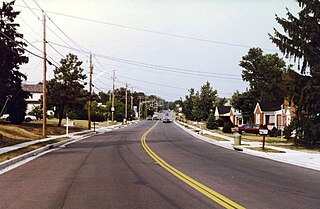
Pasadena is a census-designated place (CDP) in Anne Arundel County, Maryland, United States. The population was 24,287 at the 2010 census.

<span class="mw-page-title-main">Riviera Beach, Maryland</span> Census-designated place in Maryland, United States

Riviera Beach is a census-designated place in Anne Arundel County, Maryland, United States. The population was 12,677 at the 2010 U.S. census.

<span class="mw-page-title-main">Bowleys Quarters, Maryland</span> Census-designated place in Maryland, United States

Bowleys Quarters is an unincorporated community and census-designated place in Baltimore County, Maryland, United States, with a population of 6,755 at the 2010 census.

<span class="mw-page-title-main">Carney, Maryland</span> Census-designated place in Maryland, United States

Carney is an unincorporated community and census-designated place in Baltimore County, Maryland, United States. The population was 29,941 at the 2010 census.

<span class="mw-page-title-main">Essex, Maryland</span> Census-designated place in Maryland, United States

Essex is an unincorporated community and census-designated place in Baltimore County, Maryland, United States. Essex history dates to 1909. The population was 40,505 in the 2020 census, up from 39,262 in the 2010 census.

<span class="mw-page-title-main">Lochearn, Maryland</span> Census-designated place in Maryland, United States

Lochearn is an unincorporated community and census-designated place in Baltimore County, Maryland, United States, located immediately to the west of the City of Baltimore. Per the 2020 census, the population was 25,511.

<span class="mw-page-title-main">Milford Mill, Maryland</span> Census-designated place in Maryland, United States

Milford Mill is an unincorporated community and census-designated place in Baltimore County, Maryland, United States. Per the 2020 census, the population was 30,622.

<span class="mw-page-title-main">Overlea, Maryland</span> Census-designated place in Maryland, United States

Overlea is an unincorporated community and census-designated place in Baltimore County, Maryland, United States. The population was 12,275 at the 2010 census. Students attend Overlea High School. Area roads include Belair Road and Kenwood Avenue.

<span class="mw-page-title-main">Parkville, Maryland</span> Census-designated place in Maryland, United States

Parkville is an unincorporated community and census-designated place in Baltimore County, Maryland, United States. As of the 2010 census, the population was 30,734.

<span class="mw-page-title-main">White Marsh, Maryland</span> Census-designated place in Maryland, United States

White Marsh is an unincorporated community and census-designated place in Baltimore County, Maryland, United States. The population was 9,513 at the 2010 census. White Marsh is a northeast suburb of Baltimore.

<span class="mw-page-title-main">Bel Air North, Maryland</span> Census-designated place in Maryland, United States

Bel Air North is a census-designated place (CDP) in Harford County, Maryland, United States. It is situated immediately north of the incorporated town of Bel Air. As of the 2010 census, the CDP population was 30,568, up from 25,798 in 2000.

<span class="mw-page-title-main">Bel Air South, Maryland</span> Census-designated place in Maryland, United States

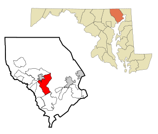
Bel Air South is a census-designated place (CDP) in Harford County, Maryland, United States. The population was 47,709 at the 2010 census, up from 39,711 in 2000.

<span class="mw-page-title-main">Perryman, Maryland</span> Census-designated place in Maryland, United States

Perryman is an unincorporated community and census-designated place (CDP) in Harford County, Maryland, United States. The population was 2,342 at the 2010 census.

<span class="mw-page-title-main">Suitland-Silver Hill, Maryland</span> Former census-designated place in Maryland

Suitland is a suburb of Prince George's County, Maryland, approximately one mile southeast of Washington, D.C., 10 miles from Alexandria, Virginia and 8.3 miles from National Harbor, Maryland. Rich in history and culture, Suitland offers plenty for residents and visitors to explore. Suitland is a census designated place (CDP) and as of the 2020 census, its population was 25,839. Prior to 2010, it was part of the Suitland-Silver Hill census-designated place.

<span class="mw-page-title-main">Calverton, Maryland</span> Census-designated place in Maryland, United States

Calverton is an unincorporated area and census-designated place located on the boundary between Montgomery and Prince George's counties, Maryland, in the United States. At the 2020 census, it had a population of 17,316.

References

  1. "2020 U.S. Gazetteer Files". United States Census Bureau. Retrieved April 26, 2022.
  2. "Profile of General Population and Housing Characteristics: 2010 Demographic Profile Data (DP-1): Rosedale CDP, Maryland". United States Census Bureau . Retrieved March 1, 2012.
  3. "William Ramsey". Archives of Maryland (Biographical Series). Maryland State Archives. Retrieved July 20, 2015.
  4. Google "list of schools in 21237"
  5. "US Gazetteer files: 2010, 2000, and 1990". United States Census Bureau. February 12, 2011. Retrieved April 23, 2011.
  6. "Census of Population and Housing". Census.gov. Retrieved June 4, 2016.
  7. 1 2 "U.S. Census website". United States Census Bureau . Retrieved January 31, 2008.
  8. "Ancestry Map of Greek Communities". Epodunk.com. Archived from the original on February 20, 2007. Retrieved April 16, 2015.