Lochearn, Maryland

Last updated

Lochearn, Maryland
2016-07-12 08 31 38 View west along Maryland State Route 26 (Liberty Road) at Liberty Terrace in Lochearn, Baltimore County, Maryland.jpg
Liberty Road at Liberty Terrace in Lochearn, Maryland
Baltimore County Maryland Incorporated and Unincorporated areas Lochearn Highlighted.svg
Location of Lochearn, Maryland
Coordinates: 39°21′2″N76°43′47″W / 39.35056°N 76.72972°W / 39.35056; -76.72972
CountryFlag of the United States.svg United States
State Flag of Maryland.svg  Maryland
County Flag of Baltimore County, Maryland.svg Baltimore
Established1882
Area
[1]
  Total5.62 sq mi (14.56 km2)
  Land5.59 sq mi (14.48 km2)
  Water0.03 sq mi (0.08 km2)
Elevation
413 ft (126 m)
Population
 (2020)
  Total25,511
  Density4,563.69/sq mi (1,761.92/km2)
Time zone UTC−5 (Eastern (EST))
  Summer (DST) UTC−4 (EDT)
ZIP Code
21207, 21208, 21215
FIPS code 24-47450
GNIS feature ID0590686

Lochearn is an unincorporated community and census-designated place in Baltimore County, Maryland, United States, located immediately to the west of the City of Baltimore. Per the 2020 census, the population was 25,511. [2]

Contents

Geography

Lochearn is bordered on the east by the Baltimore City line, on the south by Gwynn Oak Avenue, Woodlawn Drive, and Dogwood Road, on the west by the Baltimore Beltway, and on the northeast by the Baltimore Metro transit line, including the Milford Mill station. Woodmoor shopping center is located on Essex and Liberty roads.

Lochearn is located at 39°21′02″N76°43′47″W / 39.350630°N 76.729755°W / 39.350630; -76.729755 (39.350630, 76.729755). [3] According to the United States Census Bureau, the CDP has a total area of 5.6 square miles (15 km2), of which 0.04 square miles (0.10 km2), or 0.36%, is water.

Major surface thoroughfares serving Lochearn

Neighborhoods within Lochearn

Climate

The climate in this area is characterized by hot, humid summers and generally mild to cool winters. According to the Köppen Climate Classification system, Lochearn has a humid subtropical climate, abbreviated "Cfa" on climate maps. [4]

Transportation

Roads

The main road that runs through Lochearn is Liberty Road. Smaller roads serving individual communities include Buckingham Road, Croydon Road, Elba Drive, Essex Road, Lugine Avenue, Patterson Avenue, and St. Lukes Lane.

Public transportation

The Maryland Transit Administration's CityLink Lime Bus runs along Liberty Road through Lochearn.

Demographics

Historical population
CensusPop.Note
1980 26,908
1990 25,240−6.2%
2000 25,2690.1%
2010 25,3330.3%
2020 25,5110.7%
U.S. Decennial Census [5]
2010 [6] 2020 [7]

2020 census

Lochearn CDP, Maryland – Racial and ethnic composition
Note: the US Census treats Hispanic/Latino as an ethnic category. This table excludes Latinos from the racial categories and assigns them to a separate category. Hispanics/Latinos may be of any race.
Race / Ethnicity (NH = Non-Hispanic)Pop 2010 [6] Pop 2020 [7] % 2010% 2020
White alone (NH)3,2002,27212.63%8.91%
Black or African American alone (NH)20,31720,50280.20%80.37%
Native American or Alaska Native alone (NH)66580.26%0.23%
Asian alone (NH)3153601.24%1.41%
Pacific Islander alone (NH)730.03%0.01%
Some Other Race alone (NH)651390.26%0.54%
Mixed Race or Multi-Racial (NH)4637891.83%3.09%
Hispanic or Latino (any race)9001,3883.55%5.44%
Total25,33325,511100.00%100.00%

Note: the US Census treats Hispanic/Latino as an ethnic category. This table excludes Latinos from the racial categories and assigns them to a separate category. Hispanics/Latinos can be of any race.

2000 Census

At the 2000 census there were 25,269 people, 9,771 households, and 6,732 families in the CDP. The population density was 4,537.1 inhabitants per square mile (1,751.8/km2). There were 10,229 housing units at an average density of 1,836.6 per square mile (709.1/km2). The racial makeup of the CDP was 18.50% White, 78.40% African American, 0.30% Native American, 0.81% Asian, 0.04% Pacific Islander, 0.49% from other races, and 1.46% from two or more races. Hispanic or Latino of any race were 1.50%. [8] 5% of Lochearn's residents were German, 4% Irish, 3% West Indian, 2% Sub-Saharan African, 2% English, 2% Jamaican, and 2% African. [9]

Of the 9,771 households 29.6% had children under the age of 18 living with them, 42.9% were married couples living together, 21.1% had a female householder with no husband present, and 31.1% were non-families. 26.4% of households were one person and 8.1% were one person aged 65 or older. The average household size was 2.55 and the average family size was 3.06.

The age distribution was 25.1% under the age of 18, 7.8% from 18 to 24, 27.2% from 25 to 44, 26.1% from 45 to 64, and 13.7% 65 or older. The median age was 38 years. For every 100 females, there were 84.4 males. For every 100 females age 18 and over, there were 78.9 males.

The median household income was $49,517 and the median family income was $54,994. Males had a median income of $35,459 versus $30,339 for females. The per capita income for the CDP was $21,652. About 4.7% of families and 7.0% of the population were below the poverty line, including 9.3% of those under age 18 and 7.3% of those age 65 or over.

Notable native

Related Research Articles

<span class="mw-page-title-main">Brooklyn Park, Maryland</span> Census-designated place in Maryland, United States

Brooklyn Park is a census-designated place (CDP) in Anne Arundel County, Maryland, United States. The population was 14,373 at the 2010 census.

<span class="mw-page-title-main">Ferndale, Maryland</span> Census-designated place in Maryland, United States

Ferndale is a census-designated place (CDP) in Anne Arundel County, Maryland, United States. At the 2010 census, the population was 16,746.

<span class="mw-page-title-main">Essex, Maryland</span> Census-designated place in Maryland, United States

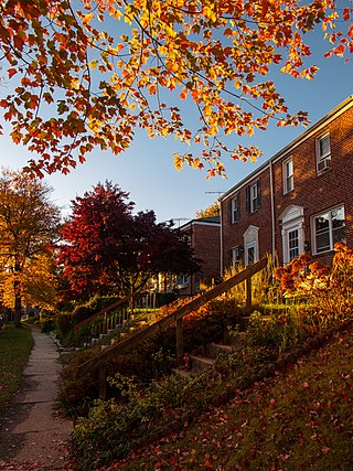
Essex is an unincorporated community and census-designated place in Baltimore County, Maryland, United States. Essex history dates back to 1909. The population was 40,505 in the 2020 census, up from 39,262 in the 2010 census.

<span class="mw-page-title-main">Hampton, Maryland</span> Census-designated place in Maryland, United States

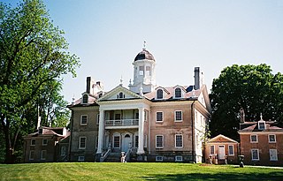
Hampton is an unincorporated community and census-designated place (CDP) in Baltimore County, Maryland, United States. The population was 5,052 at the 2010 census. Hampton is often considered a subdivision of the nearby community of Towson and is located just north of Baltimore, about twenty minutes from downtown. Hampton contains residences situated on lots up to several acres in a park-like setting. The community is anchored by its principal landmark, the Hampton National Historic Site. The Towson United Methodist Church is located in Hampton, flanked on the south by I-695 and Goucher College.

<span class="mw-page-title-main">Middle River, Maryland</span> Census-designated place in Maryland, United States

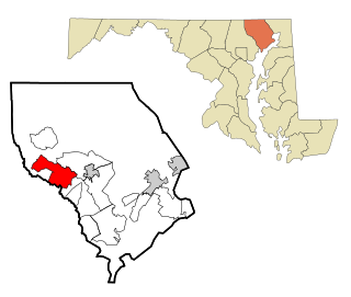
Middle River is an unincorporated community and census-designated place in Baltimore County, Maryland, United States. The population was 33,203 at the 2020 census. A Middle River Train Station first appeared on the 1877 G.M. Hopkins & Co Baltimore County Map and by 1898 had a designated Post Office and modest street grid. The town expanded during the 1930s and 1940s and established the "Aero Acres" housing community which borders the railroad tracks and Martin Blvd. to serve as housing for people working at the Martin Aerospace Company. For this development, the architecture firm of Skidmore, Owings & Merrill designed gable-roofed Cape Cod houses with dimensions of 24 feet by 28 feet, featuring large commercial-style windows in their principal rooms. In 1941 a total of 600 homes were built at Aero Acres using this design from Cemento .[2]

<span class="mw-page-title-main">Milford Mill, Maryland</span> Census-designated place in Maryland, United States

Milford Mill is an unincorporated community and census-designated place in Baltimore County, Maryland, United States. Per the 2020 census, the population was 30,622.

<span class="mw-page-title-main">Overlea, Maryland</span> Census-designated place in Maryland, United States

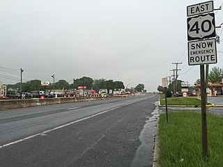
Overlea is an unincorporated community and census-designated place in Baltimore County, Maryland, United States. The population was 12,275 at the 2010 census. Students attend Overlea High School. Area roads include Belair Road and Kenwood Avenue.

<span class="mw-page-title-main">Owings Mills, Maryland</span> Census-designated place in Maryland, United States

Owings Mills is an unincorporated community and census-designated place in Baltimore County, Maryland, United States. It is a suburb of Baltimore. Per the 2020 census, the population was 35,674. Owings Mills is home to the northern terminus of the Baltimore Metro Subway, and housed the Owings Mills Mall until its closure in 2015. It is also home to the Baltimore Ravens' headquarters facility, and the studios for Maryland Public Television. In 2008, CNNMoney.com named Owings Mills number 49 of the "100 Best Places to Live and Launch".

<span class="mw-page-title-main">Parkville, Maryland</span> Census-designated place in Maryland, United States

Parkville is an unincorporated community and census-designated place in Baltimore County, Maryland, United States. As of the 2010 census, the population was 30,734.

<span class="mw-page-title-main">Pikesville, Maryland</span> Census-designated place in Maryland, United States

Pikesville is a census-designated place (CDP) in Baltimore County, Maryland, United States. Pikesville is just northwest of the Baltimore city limits. It is the northwestern suburb closest to Baltimore.

<span class="mw-page-title-main">Randallstown, Maryland</span> Census-designated place in Maryland, United States

Randallstown is an unincorporated community and census-designated place in Baltimore County, Maryland, United States. It is named after Christopher and Thomas Randall, two 18th-century tavern-keepers. At that time, Randallstown was a tollgate crossroads on the Liberty Turnpike, a major east–west thoroughfare. It is a suburb of Baltimore, with a population of 33,655 as of the 2020 census. As of 2020 it was 72 percent African American. In the 1990s, Randallstown transitioned to a majority African American community.

<span class="mw-page-title-main">Reisterstown, Maryland</span> Census-designated place in Maryland, United States

Reisterstown is an unincorporated community and census-designated place in Baltimore County, Maryland, United States. As of the 2010 census, it had a population of 25,968.

<span class="mw-page-title-main">Rosedale, Maryland</span> Census-designated place in Maryland, United States

Rosedale is an unincorporated community and census-designated place in Baltimore County, Maryland, United States. The population was 19,257 at the 2010 United States Census.

<span class="mw-page-title-main">Woodlawn, Baltimore County, Maryland</span> Place in Maryland, United States

Woodlawn is an unincorporated community and census-designated place in Baltimore County, Maryland. Per the 2020 census, the population was 39,986. It is home to the headquarters of the Social Security Administration (SSA) and the Centers for Medicare and Medicaid Services (CMS). It is bordered by Catonsville on the south, by the Patapsco River and Howard County on the west, by Randallstown and Lochearn to the north, and by the City of Baltimore to the east. Parts of Woodlawn are sometimes informally referred to as Security, Maryland, due to the importance of the SSA's headquarters as well as nearby Security Boulevard and Security Square Mall.

<span class="mw-page-title-main">Eldersburg, Maryland</span> Census-designated place in Maryland, United States

Eldersburg is an unincorporated community and census-designated place (CDP) in Carroll County, Maryland, United States. The population was 30,531 at the 2010 census.

<span class="mw-page-title-main">Fallston, Maryland</span> Census-designated place in Maryland, United States

Fallston is a census-designated place (CDP) in Harford County, Maryland, United States. The population was 8,958 at the 2010 census, up from 8,427 in 2000. Fallston is a semi-rural community consisting mostly of farms and suburban-like developments.

<span class="mw-page-title-main">Perryman, Maryland</span> Census-designated place in Maryland, United States

Perryman is an unincorporated community and census-designated place (CDP) in Harford County, Maryland, United States. The population was 2,342 at the 2010 census.

<span class="mw-page-title-main">Beltsville, Maryland</span> CDP in Maryland, United States

Beltsville is a census-designated place (CDP) in northern Prince George's County, Maryland, United States. The community was named for Truman Belt, a local landowner. The 2020 census counted 20,133 residents. Beltsville includes the unincorporated community of Vansville.

<span class="mw-page-title-main">Glenn Dale, Maryland</span> CDP in Maryland

Glenn Dale is an unincorporated area and census-designated place (CDP) in Prince George's County, Maryland, United States. The population was 14,698 at the 2020 census. Glenn Dale is home to the Glenn Dale Hospital, an abandoned sanatorium, and the USDA Plant Introduction Station.

<span class="mw-page-title-main">South Laurel, Maryland</span> Census-designated place in Maryland

South Laurel is an unincorporated area and census-designated place (CDP) in Prince George's County, Maryland, United States. Per the 2020 census, the population was 29,602.

References

  1. "2020 U.S. Gazetteer Files". United States Census Bureau. Retrieved April 26, 2022.
  2. "Lochearn CDP, Maryland". United States Census Bureau . Retrieved April 15, 2022.
  3. "US Gazetteer files: 2010, 2000, and 1990". United States Census Bureau. February 12, 2011. Retrieved April 23, 2011.
  4. Climate Summary for Lochearn, Maryland
  5. "Decennial Census of Population and Housing by Decades". US Census Bureau.
  6. 1 2 "P2 Hispanic or Latino, and Not Hispanic or Latino by Race – 2010: DEC Redistricting Data (PL 94-171) – Lochearn CDP, Maryland". United States Census Bureau .
  7. 1 2 "P2 Hispanic or Latino, and Not Hispanic or Latino by Race – 2020: DEC Redistricting Data (PL 94-171) – Lochearn CDP, Maryland". United States Census Bureau .
  8. "U.S. Census website". United States Census Bureau . Retrieved January 31, 2008.
  9. "Lochearn, MD, Ancestry & Family History". Epodunk.com. Retrieved April 16, 2015.