Baltimore County is the third-most populous county in the U.S. state of Maryland and is part of the Baltimore metropolitan area. Baltimore County is part of the Northeast megalopolis, which stretches from Northern Virginia northward to Boston. Baltimore County hosts a diversified economy, with particular emphasis on education, government, and health care. As of the 2020 census, the population was 854,535.

Harford County is located in the U.S. state of Maryland. As of the 2020 census, the population was 260,924. Its county seat is Bel Air. Harford County is included in the Baltimore-Columbia-Towson, MD Metropolitan Statistical Area, which is also included in the Washington-Baltimore-Arlington, DC-MD-VA-WV-PA Combined Statistical Area.
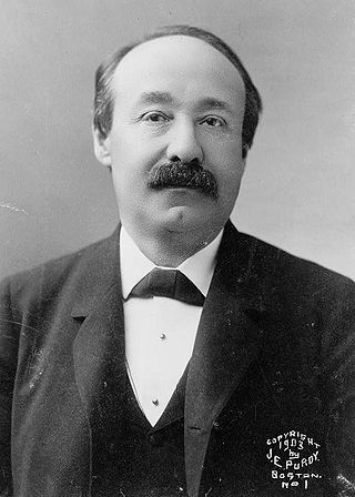
Charles Joseph Bonaparte was an American lawyer and political activist for progressive and liberal causes. Originally from Baltimore, Maryland, he served in the cabinet of the 26th U.S. president, Theodore Roosevelt. He was a descendant of the House of Bonaparte: his grandfather was Jérôme Bonaparte, brother of Emperor Napoleon.

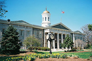
Towson is an unincorporated community and a census-designated place in Baltimore County, Maryland, United States. The population was 55,197 as of the 2010 census. It is the county seat of Baltimore County and the second-most populous unincorporated county seat in the United States.

The town of Bel Air is the county seat of Harford County, Maryland. According to the 2020 United States census, the population of the town was 10,661.
U.S. Route 140 was a U.S. highway connecting Gettysburg, Pennsylvania to Baltimore, Maryland. The route was deleted from the system in 1979; today the road's route is followed by portions of Pennsylvania Route 97, Maryland Route 97, and Maryland Route 140.
Ruxton and Riderwood are unincorporated communities in Baltimore County, Maryland, United States. They are sometimes considered a part of Towson and are part of Towson's census area.

The Northern Central Railway (NCRY) was a Class I Railroad connecting Baltimore, Maryland with Sunbury, Pennsylvania, along the Susquehanna River. Completed in 1858, the line came under the control of the Pennsylvania Railroad (PRR) in 1861, when the PRR acquired a controlling interest in the Northern Central's stock to compete with the rival Baltimore and Ohio Railroad (B&O). For eleven decades the Northern Central operated as a subsidiary of the PRR until much of its Maryland trackage was washed out by Hurricane Agnes in 1972, after which most of its operations ceased as the Penn Central declined to repair sections. It is now a fallen flag railway, having come under the control of the later Penn Central, Conrail, and then broken apart and disestablished. The northern part in Pennsylvania is now the York County Heritage Rail Trail which connects to a similar hike/bike trail in Northern Maryland down to Baltimore, named the Torrey C. Brown Rail Trail. Trackage around Baltimore remains in rail service as well as most of the trackage in Pennsylvania which is operated by Norfolk Southern and the southernmost section in Pennsylvania is operated by the Northern Central heritage railway.

Maryland Route 147 is a state highway in the U.S. state of Maryland. Known as Harford Road, the state highway runs 18.82 miles (30.29 km) from U.S. Route 1 and US 40 Truck in Baltimore north to US 1 and US 1 Business in Benson. MD 147 is an alternate route to US 1 between Baltimore and Bel Air, the county seat of Harford County. The state highway is the main street of several neighborhoods in Northeast Baltimore and the Baltimore County suburbs of Parkville and Carney. MD 147 is maintained by the Maryland State Highway Administration in Baltimore and Harford counties and by the Baltimore City Department of Transportation within the city. Harford Road was a pair of turnpikes before the Baltimore–Carney portion of the highway was designated one of the original state roads. The Baltimore County section of MD 147 was constructed in the early 1910s and widened multiple times in the late 1920s and 1930s. The section of the state highway in Harford County was built in the late 1920s.
Monkton is an unincorporated community in northern Baltimore County, Maryland, United States. It has a population of approximately 4,856 people. The community is 35 square miles (91 km2) in area, with approximately 138 inhabitants per square mile (53/km2). As an unincorporated area, Monkton has no legally defined boundaries, and its ZIP code (21111) includes a portion of adjacent Harford County.

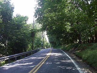
Maryland Route 23 is a state highway in the U.S. state of Maryland. The state highway runs 20.58 miles (33.12 km) from U.S. Route 1 in Hickory north and west to the Pennsylvania state line near Norrisville, where the highway continues as Pennsylvania Route 24. MD 23 is an L-shaped highway in northwestern Harford County that consists of two major sections. Between US 1 and MD 165 in Jarrettsville, MD 23 is marked east–west along a two-lane road with partial control of access named East–West Highway. From MD 165 to the state line, the state highway is marked north–south along Norrisville Road, a rural two-lane highway that passes through the villages of Madonna and Shawsville. The two sections of MD 23 are connected by a short concurrency with MD 165.

U.S. Route 1 (US 1) is the easternmost and longest of the major north–south routes of the older 1920s era United States Numbered Highway System, running from Key West, Florida, to Fort Kent, Maine. In the U.S. state of Maryland, it runs 81 miles (130 km) from the Washington DC line to the Pennsylvania state line near the town of Rising Sun.
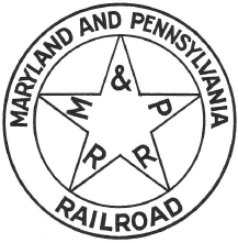
The Maryland and Pennsylvania Railroad, familiarly known as the "Ma and Pa", was an American short-line railroad between York and Hanover, Pennsylvania, formerly operating passenger and freight trains on its original line between York and Baltimore, Maryland, from 1901 until the 1950s. The Ma and Pa was popular with railfans in the 1930s and 1940s for its antique equipment and curving, picturesque right-of-way through the hills of rural Maryland and Pennsylvania. Reflecting its origin as the unintended product of the merger of two 19th-century narrow gauge railways, the meandering Ma and Pa line took 77.2 miles (124 km) to connect Baltimore and York, although the two cities are only 45 miles (72 km) apart in a straight line.
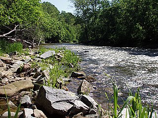
Deer Creek is a 52.9-mile-long (85.1 km) river in Maryland and Pennsylvania that flows through the scenic areas of Harford County and empties into the Susquehanna River, roughly halfway between the Interstate 95 bridge and Conowingo Dam. Its watershed area is 171 square miles (440 km2). Its watershed area in MD is 145 square miles (380 km2), with 3% impervious surface in 1994. It serves as a divider between the agricultural and urban/suburban areas of Harford County.
Cromwell Bridge Road, formerly Maryland Route 567, is a two-lane roadway in the Towson, Maryland area of the United States. The road begins at Providence Road in Towson, and continues past the Baltimore Beltway for several miles along the Cromwell Valley to its end, where it splits, a left turn going onto Glen Arm Road and a right turn onto Cub Hill Road.
Old Harford Road, one of the oldest continuously used rights-of-way in central Maryland, United States, is a southwest–northeast thoroughfare in northeast Baltimore City and eastern Baltimore County.
James Crawford Neilson, or J. Crawford Neilson, was a Baltimore, Maryland-based architect. He was born in Baltimore, Maryland in 1816. After the death of his father in 1822 the family moved to England and in 1824 to Brussels. In 1833, he returned to Baltimore and in 1835, became a member of the survey party working on the Baltimore and Port Deposit Railroad,. His supervisor was Benjamin Henry Latrobe, II, (1806-1878), later supervising engineer on the Baltimore and Ohio Railroad,, son of an equally famous architect, Benjamin Henry Latrobe, (1764-1820). It was at this time that he first became acquainted with John Rudolph Niernsee, (1814-1885), while helping to survey in the area of Martinsburg, Virginia, for the Baltimore and Ohio Railroad.

Charles Adler Jr. was an American inventor and engineer. He is most known for developing devices meant to improve transportation safety, including sonically actuated traffic lights, colorblind road signals, pedestrian push-buttons, and flashing aircraft lights.
The Baltimore, Philadelphia and New York Railroad was a paper railroad of the 1870s, vaguely projected to construct a new line between Baltimore and New York via Philadelphia. It did very little construction work, except for a few miles of grading from Relay House, on the Northern Central Railroad, through Towson, Maryland to the Gunpowder River. It merged with the bankrupt Wilmington and Reading Railroad in 1875, but failed to attract further investment to complete its own line. The two railroads were both reorganized separately after foreclosures. Most of the grade was sold to the Baltimore and Delta Railway.


