Milford Mill, Maryland

Last updated

Milford Mill, Maryland
Milford Mill HS 3.jpg
Milford Mill Academy in Milford Mill, Maryland
Baltimore County Maryland Incorporated and Unincorporated areas Milford Mill Highlighted.svg
Coordinates: 39°20′50″N76°45′39″W / 39.34722°N 76.76083°W / 39.34722; -76.76083
Country Flag of the United States.svg United States
State Flag of Maryland.svg  Maryland
County Flag of Baltimore County, Maryland.svg Baltimore
Area
[1]
  Total6.96 sq mi (18.02 km2)
  Land6.95 sq mi (17.99 km2)
  Water0.01 sq mi (0.03 km2)
Elevation
495 ft (151 m)
Population
 (2020)
  Total30,622
  Density4,409.22/sq mi (1,702.49/km2)
Time zone UTC−5 (Eastern (EST))
  Summer (DST) UTC−4 (EDT)
ZIP Code
21244, 21133, 21208
FIPS code 24-52562
GNIS feature ID1867296

Milford Mill is an unincorporated community and census-designated place in Baltimore County, Maryland, United States. Per the 2020 census, the population was 30,622. [2]

Contents

According to the United States Census Bureau, the CDP has a total area of 7.0 square miles (18 km2), all of it land.

The true name of the area is "Milford", but the name "Milford Mill" has stuck with the community. The name "Milford Mill" comes from the name of an old mill located in nearby Pikesville along Milford Mill Road. [3]

Geography

Milford Mill is located at 39°20′50″N76°45′39″W / 39.34722°N 76.76083°W / 39.34722; -76.76083 (39.347356, 76.760924). [4]

Milford Mill is near the Baltimore County communities of Pikesville, Randallstown, and Woodlawn, around the intersection of Liberty Road and Milford Mill Road. Some areas of Milford Mill are as follows:

Windsor Mill

Windsor Mill is an area near Woodlawn that is similar to Milford Mill. Some of the main roads in the area include Windsor Mill Road, Windsor Boulevard, and Rolling Road. Landmarks in this area include Windsor Mill Middle School and Rutherford Business Park.

Rockdale

Rockdale is mostly near Liberty Road and Lord Baltimore Drive to Rolling Road coming off from I-695. Landmarks in this area include schools like Scotts Branch Elementary and Old Court Middle School.

Demographics

Historical population
CensusPop.Note
1980 20,354
1990 22,54710.8%
2000 26,52717.7%
2010 29,0429.5%
2020 30,6225.4%
U.S. Decennial Census [5]
2010 [6] 2020 [7]

2020 census

Milford Mill CDP, Maryland – Racial and ethnic composition
Note: the US Census treats Hispanic/Latino as an ethnic category. This table excludes Latinos from the racial categories and assigns them to a separate category. Hispanics/Latinos may be of any race.
Race / Ethnicity (NH = Non-Hispanic)Pop 2010 [6] Pop 2020 [7] % 2010% 2020
White alone (NH)2,2531,6967.76%5.54%
Black or African American alone (NH)24,33325,36083.79%82.82%
Native American or Alaska Native alone (NH)55570.19%0.19%
Asian alone (NH)6866982.36%2.28%
Pacific Islander alone (NH)670.02%0.02%
Some Other Race alone (NH)461720.16%0.56%
Mixed Race or Multi-Racial (NH)5908852.03%2.89%
Hispanic or Latino (any race)1,0731,7473.69%5.71%
Total29,04230,622100.00%100.00%

2000 Census

At the 2000 census there were 26,527 people, 10,467 households, and 6,855 families in the CDP. The population density was 3,804.3 inhabitants per square mile (1,468.8/km2). There were 11,217 housing units at an average density of 1,608.7 per square mile (621.1/km2). The racial makeup of the CDP was 16.19% White, 79.06% African American, 0.21% Native American, 1.67% Asian, 0.02% Pacific Islander, 0.74% from other races, and 2.11% from two or more races. Hispanic or Latino of any race were 1.82%. [8]

Of the 10,467 households 34.6% had children under the age of 18 living with them, 35.4% were married couples living together, 24.6% had a female householder with no husband present, and 34.5% were non-families. 27.5% of households were one person and 5.4% were one person aged 65 or older. The average household size was 2.49 and the average family size was 3.02.

The age distribution was 27.7% under the age of 18, 8.9% from 18 to 24, 33.2% from 25 to 44, 21.0% from 45 to 64, and 9.1% 65 or older. The median age was 33 years. For every 100 females, there were 82.9 males. For every 100 females age 18 and over, there were 76.2 males.

The median household income was $43,976 and the median family income was $49,177. Males had a median income of $33,725 versus $31,230 for females. The per capita income for the CDP was $20,195. About 6.7% of families and 8.3% of the population were below the poverty line, including 8.8% of those under age 18 and 10.0% of those age 65 or over.

Government and infrastructure

The Federal Bureau of Investigation (FBI) Baltimore field office is located in Milford Mill. [9] [10]

Education

Baltimore County Public Schools operates public schools.

See also

Related Research Articles

<span class="mw-page-title-main">Shenandoah, Louisiana</span> Census-designated place in Louisiana, United States

Shenandoah is an unincorporated area and census-designated place (CDP) in East Baton Rouge Parish, Louisiana, United States. It is part of the Baton Rouge Metropolitan Statistical Area. The population was 18,399 at the 2010 census, up from 17,070 in 2000. Shenandoah consists of a number of residential subdivisions, including Shenandoah Estates, Shenandoah Park, White Oak Landing, White Oak Estates, The Woods and The Lake at White Oak.

<span class="mw-page-title-main">Brooklyn Park, Maryland</span> Census-designated place in Maryland, United States

Brooklyn Park is a census-designated place (CDP) in Anne Arundel County, Maryland, United States. The population was 14,373 at the 2010 census.

<span class="mw-page-title-main">Ferndale, Maryland</span> Census-designated place in Maryland, United States

Ferndale is a census-designated place (CDP) in Anne Arundel County, Maryland, United States. At the 2010 census, the population was 16,746.

<span class="mw-page-title-main">Arbutus, Maryland</span> Census-designated place in Maryland, United States

Arbutus is an unincorporated community and a census-designated place in Baltimore County, Maryland, United States. The population was 20,483 at the 2010 census. The census area also contains the communities of Halethorpe and Relay, in which all three names were used during the 1960 census when the area had a population of 22,402.

<span class="mw-page-title-main">Garrison, Maryland</span> Census-designated place in Maryland, United States

Garrison is a census-designated place (CDP) in Baltimore County, Maryland, United States, adjacent to Owings Mills. It consists mainly of the McDonogh area and Valley Centre. The population was 8,823 at the 2010 census.

<span class="mw-page-title-main">Lochearn, Maryland</span> Census-designated place in Maryland, United States

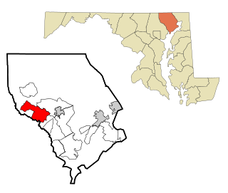
Lochearn is an unincorporated community and census-designated place in Baltimore County, Maryland, United States, located immediately to the west of the City of Baltimore. Per the 2020 census, the population was 25,511.

<span class="mw-page-title-main">Owings Mills, Maryland</span> Census-designated place in Maryland, United States

Owings Mills is an unincorporated community and census-designated place in Baltimore County, Maryland, United States. It is a suburb of Baltimore. Per the 2020 census, the population was 35,674. Owings Mills is home to the northern terminus of the Baltimore Metro Subway, and housed the Owings Mills Mall until its closure in 2015. It is also home to the Baltimore Ravens' headquarters facility, and the studios for Maryland Public Television. In 2008, CNNMoney.com named Owings Mills number 49 of the "100 Best Places to Live and Launch".

<span class="mw-page-title-main">Pikesville, Maryland</span> Census-designated place in Maryland, United States

Pikesville is a census-designated place (CDP) in Baltimore County, Maryland, United States. Pikesville is just northwest of the Baltimore city limits. It is the northwestern suburb closest to Baltimore.

<span class="mw-page-title-main">Randallstown, Maryland</span> Census-designated place in Maryland, United States

Randallstown is an unincorporated community and census-designated place in Baltimore County, Maryland, United States. It is named after Christopher and Thomas Randall, two 18th-century tavern-keepers. At that time, Randallstown was a tollgate crossroads on the Liberty Turnpike, a major east–west thoroughfare. It is a suburb of Baltimore, with a population of 33,655 as of the 2020 census. As of 2020 it was 72 percent African American. In the 1990s, Randallstown transitioned to a majority African American community.

<span class="mw-page-title-main">Rosedale, Maryland</span> Census-designated place in Maryland, United States

Rosedale is an unincorporated community and census-designated place in Baltimore County, Maryland, United States. The population was 19,257 at the 2010 United States Census.

<span class="mw-page-title-main">Woodlawn, Baltimore County, Maryland</span> Place in Maryland, United States

Woodlawn is an unincorporated community and census-designated place in Baltimore County, Maryland. Per the 2020 census, the population was 39,986. It is home to the headquarters of the Social Security Administration (SSA) and the Centers for Medicare and Medicaid Services (CMS). It is bordered by Catonsville on the south, by the Patapsco River and Howard County on the west, by Randallstown and Lochearn to the north, and by the City of Baltimore to the east. Parts of Woodlawn are sometimes informally referred to as Security, Maryland, due to the importance of the SSA's headquarters as well as nearby Security Boulevard and Security Square Mall.

<span class="mw-page-title-main">Eldersburg, Maryland</span> Census-designated place in Maryland, United States

Eldersburg is an unincorporated community and census-designated place (CDP) in Carroll County, Maryland, United States. The population was 30,531 at the 2010 census.

<span class="mw-page-title-main">Bel Air North, Maryland</span> Census-designated place in Maryland, United States

Bel Air North is a census-designated place (CDP) in Harford County, Maryland, United States. It is situated immediately north of the incorporated town of Bel Air. As of the 2010 census, the CDP population was 30,568, up from 25,798 in 2000.

<span class="mw-page-title-main">Fallston, Maryland</span> Census-designated place in Maryland, United States

Fallston is a census-designated place (CDP) in Harford County, Maryland, United States. The population was 8,958 at the 2010 census, up from 8,427 in 2000. Fallston is a semi-rural community consisting mostly of farms and suburban-like developments.

<span class="mw-page-title-main">Adelphi, Maryland</span> Census-designated place in Maryland

Adelphi is an unincorporated area and census-designated place in Prince George's County, Maryland, United States. Per the 2020 Census, the population was 16,823. Adelphi includes the following subdivisions; Adelphi, Adelphi Park, Adelphi Hills, Adelphi Terrace, Adelphi Village, Buck Lodge, Chatham, Cool Spring Terrace, Hillandale Forest, Holly Hill Manor, Knollwood, Lewisdale, and White Oak Manor.

<span class="mw-page-title-main">Walker Mill, Maryland</span> Census-designated place in Maryland

Walker Mill is an unincorporated area and census-designated place (CDP) in Prince George's County, Maryland, United States. Per the 2020 census, the population was 12,187.

<span class="mw-page-title-main">West Laurel, Maryland</span> Census-designated place in Maryland

West Laurel is an unincorporated area and census-designated place (CDP) in Prince George's County, Maryland, United States. Per the 2020 census, the population was 4,428.

<span class="mw-page-title-main">Woodlawn, Prince George's County, Maryland</span> Census-designated place in Maryland

Woodlawn is an unincorporated area and census-designated place (CDP) in Prince George's County, Maryland, United States. As of the 2020 census it had a population of 7,541.

<span class="mw-page-title-main">Calverton, Maryland</span> Census-designated place in Maryland, United States

Calverton is an unincorporated area and census-designated place located on the boundary between Montgomery and Prince George's counties, Maryland, in the United States. At the 2020 census, it had a population of 17,316.

<span class="mw-page-title-main">Baltimore Highlands, Maryland</span> Census-designated place in Maryland, United States

Baltimore Highlands is a census-designated place (CDP) in Baltimore County, Maryland, United States, directly south of the city of Baltimore. The population was 7,019 at the 2010 census. At the 2000 census and earlier, the area was delineated as part of the Lansdowne-Baltimore Highlands CDP.

References

  1. "2020 U.S. Gazetteer Files". United States Census Bureau. Retrieved April 26, 2022.
  2. "Milford Mill CDP, Maryland". United States Census Bureau . Retrieved April 15, 2022.
  3. "Not so easy to find, but very easy to like".
  4. "US Gazetteer files: 2010, 2000, and 1990". United States Census Bureau. February 12, 2011. Retrieved April 23, 2011.
  5. "Decennial Census of Population and Housing by Decades". US Census Bureau.
  6. 1 2 "P2 Hispanic or Latino, and Not Hispanic or Latino by Race – 2010: DEC Redistricting Data (PL 94-171) – Milford Mill CDP, Maryland". United States Census Bureau .
  7. 1 2 "P2 Hispanic or Latino, and Not Hispanic or Latino by Race – 2020: DEC Redistricting Data (PL 94-171) – Milford Mill CDP, Maryland". United States Census Bureau .
  8. "U.S. Census website". United States Census Bureau . Retrieved January 31, 2008.
  9. "Baltimore Division." Federal Bureau of Investigation. Retrieved on June 9, 2015. "2600 Lord Baltimore Drive Baltimore, MD 21244"
  10. "2010 CENSUS - CENSUS BLOCK MAP: Milford Mill CDP, MD" (Archive) (Map 2). U.S. Census Bureau. Retrieved on June 9, 2015.