Ruxton-Riderwood, Maryland

Last updated

Ruxton-Riderwood
CountryUS
StateFlag of Maryland.svg  Maryland
County Flag of Baltimore County, Maryland.svg Baltimore County
Population
 (2020)
  Total21,378
Time zone UTC-5 (EST)
  Summer (DST) UTC-4 (EDT)
ZIP Codes
21204
Area code 443|667
Website rrlraia.org

Ruxton and Riderwood are unincorporated communities in Baltimore County, Maryland, United States. They are sometimes considered a part of Towson and are part of Towson's census area.

Contents

The boundaries of Ruxton have been established largely by local custom. Both the eastern boundary, Charles Street, and the western, Falls Road, are generally agreed upon. The northern and southern boundaries are somewhat imprecise. To the north and northwest, affiliation with Ruxton follows Joppa Road, the Old Court Road extension alongside the Jones Falls Expressway (I-83), and finally Ruxton Road to its intersection with Falls. A southern boundary can be discerned by drawing a crude line from the southerly intersection of Bellona Avenue (MD-134) and Charles to the intersection of West Lake Avenue and Falls. Riderwood's northern boundary is generally agreed upon as the Baltimore Beltway (I-695). To the southwest, south, and east, affiliation with Riderwood follows Joppa Road from its overpass of the Beltway to its bridge over Charles Street and along Charles Street to its interchange with the Beltway.

The commercial center of Ruxton, Ruxton Village, is centered around the intersection of Bellona Avenue and Ruxton Road. Riderwood hosts two smaller villages; one located along Bellona Avenue just north of its intersection with Joppa Road, and another centered around the intersection of Joppa and Thornton Roads.

History

Ruxton takes its name from Nicholas Ruxton Moore, a captain and commander of the Baltimore Light Dragoons during the American Revolution War and a United States Congressman for Maryland's 5th District. He also participated in suppressing the Whiskey Rebellion in 1794, the same year he purchased the land that would become Ruxton. [1] Riderwood takes its name from the family of Edward Rider, who obtained a 150-acre farm and mill near Thornton Road in 1824. [2]

Ruxton was once the location of the country estates of Baltimore's wealthy landed gentry. Though the area became suburbanized during the course of the twentieth century, Ruxton is still considered one of the premier neighborhoods in the Baltimore area, along with Roland Park, Homeland, Guilford and the Falls Road corridor. Many of the original estates still remain, though there have been many new homes built between them. One 1905 home, formerly a railroad station, was designed by renowned Gilded Age architect Frank Furness. [3]

Like much of Maryland, slavery was present in the Ruxton and Riderwood communities during the 18th century, despite local Quaker and Methodist resistance. In 1790, enslaved people comprised nearly 45% of the area's population. [4] In 1833, J. Aquilla Scott, a free Black man, founded St. John's Church, a historic A.U.M.P. Church. The first iteration of the church burned down in 1876, and the subsequent 1886 structure was listed on the National Register of Historic Places in 1982. [5]

President Abraham Lincoln traveled through Ruxton and Riderwood en route to Gettysburg, Pennsylvania, to deliver the Gettysburg Address in November, 1863. Less than two years later, on April 21, 1865, Lincoln's funeral train also passed through Ruxton and Riderwood on its way from Washington, D.C., to his final resting place at Springfield, Illinois. [6] [7]

In 1854, the neighborhood was the site of a train collision that killed 30 passengers. At the time, it was one of the worst railroad accidents in United States history. [8]

Transportation

Roads

Ruxton Road

Ruxton Road is a 1½-mile road, bearing the name of the area, and is the main west-east road running through the area. The road is mostly lined with upscale housing, but also has an interchange with the Jones Falls Expressway (exit 12). The road begins as a physical continuation to Old Court Road (though an extension to Old Court exists following a left turn), then continues past Bellona Avenue following a crossing over the track of the Light Rail finally ending at Malvern Avenue. There is no stop along the Light Rail at this point.

Bellona Avenue

Maryland Route 134, better known as Bellona Avenue is the main north-south road running through Ruxton and Riderwood. From the portion of Bellona Avenue through these communities, the track of the Light Rail is visible, though there are no stops. A small number of apartments and historic shopping districts can be found along Bellona Avenue, though the remainder of the road is mostly undeveloped.

West Joppa Road

West Joppa Road, a major cross-county artery, passes through Riderwood as it intersects with Bellona Avenue. The road is mostly lined with upscale housing. Joppa Road ends in the west at nearby Greenspring Station.

Falls Road

Maryland Route 25, better known as Falls Road, forms part of the western boundary of these communities, leading to the Brooklandville area. Though the road has a mostly sparse appearance, a small number of landmarks are visible in this area, including The Cloisters and Brightwood Nursing Home.

Charles Street

Maryland Route 139, better known as Charles Street, is said by many to form the eastern boundary of Ruxton. Several landmarks on this route, which intersects with I-695 in this area (exit 25), contain "Ruxton" in their name.

Thornton Road

Thornton Road connects the Riderwood neighborhood to Ruxton, reaching from West Joppa Road to the Mays Chapel area, stretching under the Baltimore Beltway. It provides access to Riderwood Elementary School and Village Green, its surrounding development, as well as Valley Country Club.

Public transportation

Prior to 1990, buses operated along Ruxton Road. However, bus service in the Ruxton area is very limited. LocalLink Route 34 operates on Falls Road on weekdays, though it is seldom used to reach this area. LocalLink Route 51 (formerly Route 11), which operates mostly along Charles Street, formerly operated two daily trips along Bellona Avenue through Ruxton running as Route 11A, though ridership in this area was very low. The service was discontinued after the redesign of the MTA bus system in 2017.

Passenger train at Riderwood station in 1917 PRR train at Riderwood Md.jpg
Passenger train at Riderwood station in 1917

A railroad has existed in Ruxton and Riverwood since 1831, when the Baltimore & Susquehanna Railroad was first built to Cockeysville, later becoming part of the Northern Central Railway. As a wholly owned subsidiary of the giant Pennsylvania Railroad in the 20th century, long-distance passenger trains passed over the line to Harrisburg, Pennsylvania, and beyond to Chicago, Buffalo, and St. Louis. In addition, local commuter trains stopped at stations in both Ruxton and Riverwood until 1959. Long-distance passenger train service ended in the late 1960s, although the Norfolk Southern Railway continued late-night freight operations until 2005, sharing the Light Rail Line as far as Cockeysville by agreement with the Maryland Transit Administration.

No Light Rail trains stop in Ruxton or Riderwood. Although stops were considered in the Ruxton and Riderwood areas when the light rail was proposed, these were fought by area residents. [9]

In 1994, the movie Serial Mom was filmed in Ruxton at the Church of the Good Shepherd, on Boyce Avenue. [10]

In 2005, Australian actress Nicole Kidman moved into Ruxton, renting a house in the Four Winds neighborhood, on Boyce Avenue, as she filmed her movie The Invasion in Downtown Baltimore, opposite Daniel Craig.

Scenes in "Runaway Bride" with Julia Roberts and Richard Gere were filmed at Gill's Garage on West Joppa Road.

Schools

Ruxton is served by Riderwood Elementary School, Dumbarton Middle School, and Towson High School, all Blue Ribbon Schools in the Baltimore County Public Schools system. However, a large majority of Ruxton students attend area private schools such as St. Paul's School, Gilman School, Loyola Blakefield, Roland Park Country School (RPCS), Friends School, McDonogh School, Bryn Mawr School, Boys' Latin School, and Garrison Forest School in Owings Mills.

Recreation

The L'Hirondelle Country Club is located in Ruxton.

Valley Country Club is located in Riderwood, featuring a pool, tennis and basketball courts, and a mansion, formerly owned by NFL Hall of Famer and Baltimore Colts defensive tackle Art Donovan. [11]

Lake Roland Park covers a large area in and around Ruxton. The park provides a densely wooded area containing hiking trails, a stream, and Lake Roland. [12]

Related Research Articles

<span class="mw-page-title-main">Towson, Maryland</span> Census-designated place in Maryland, United States

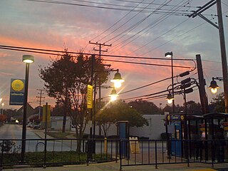
Towson is an unincorporated community and a census-designated place in Baltimore County, Maryland, United States. The population was 55,197 as of the 2010 census. It is the county seat of Baltimore County and the second-most populous unincorporated county seat in the United States.

<span class="mw-page-title-main">Maryland Route 45</span> State highway in Maryland, US

Maryland Route 45 is a state highway in the U.S. state of Maryland. Known for most of its length as York Road, the state highway runs 30.06 miles (48.38 km) from U.S. Route 1 /US 40 Truck in Baltimore north to the Pennsylvania state line in Maryland Line, where the highway continues as State Route 3001. MD 45 is the primary highway between Downtown Baltimore and Towson, the county seat of Baltimore County. North of Interstate 695 (I-695), the state highway parallels I-83 and serves the suburban communities of Lutherville, Timonium, Cockeysville, and Hunt Valley. MD 45 also connects the northern Baltimore County communities of Hereford and Parkton. The state highway is maintained by the Maryland State Highway Administration in Baltimore County and by the Baltimore City Department of Transportation in the city, where the highway also follows Greenmount Avenue.

<span class="mw-page-title-main">Mount Washington, Baltimore</span> United States historic place

Mount Washington is an area of northwest Baltimore, Maryland. It is a designated city historic district and divided into two sections: South Road/Sulgrave to the southeast and Dixon's Hill to the north. The Mount Washington Historic District was listed on the National Register of Historic Places in 1990 with a boundary increase in 2001, with five contributing buildings and four contributing structures.

<span class="mw-page-title-main">Maryland Route 147</span> State highway in Maryland, known as Harford Road

Maryland Route 147 is a state highway in the U.S. state of Maryland. Known as Harford Road, the state highway runs 18.82 miles (30.29 km) from U.S. Route 1 and US 40 Truck in Baltimore north to US 1 and US 1 Business in Benson. MD 147 is an alternate route to US 1 between Baltimore and Bel Air, the county seat of Harford County. The state highway is the main street of several neighborhoods in Northeast Baltimore and the Baltimore County suburbs of Parkville and Carney. MD 147 is maintained by the Maryland State Highway Administration in Baltimore and Harford counties and by the Baltimore City Department of Transportation within the city. Harford Road was a pair of turnpikes before the Baltimore–Carney portion of the highway was designated one of the original state roads. The Baltimore County section of MD 147 was constructed in the early 1910s and widened multiple times in the late 1920s and 1930s. The section of the state highway in Harford County was built in the late 1920s.

<span class="mw-page-title-main">Lutherville, Maryland</span> Census-designated place in Maryland, United States

Lutherville is a census-designated place (CDP) in Baltimore County, Maryland, United States. As of the 2010 census it had a population of 6,504. Prior to 2010 the area was part of the Lutherville-Timonium CDP. Within its borders lies the Lutherville Historic District.

<span class="mw-page-title-main">Charles Street (Baltimore)</span> State Highway in Maryland, US

Charles Street, known for most of its route as Maryland Route 139, runs through Baltimore and the Towson area of Baltimore County. On the north end, it terminates at an intersection with Bellona Avenue near Interstate 695 (I-695). At the south end, it terminates in Federal Hill in Baltimore. Charles Street is one of the major routes through Baltimore, and is a major public transportation corridor. For the one-way portions of Charles Street, the street is functionally complemented by the parallel St. Paul Street, including St. Paul Place and Preston Gardens, Maryland Avenue, Cathedral Street, and Liberty Street.

<span class="mw-page-title-main">U.S. Route 1 in Maryland</span> Section of U.S. Route in Maryland, United States

U.S. Route 1 (US 1) is the easternmost and longest of the major north–south routes of the older 1920s era United States Numbered Highway System, running from Key West, Florida, to Fort Kent, Maine. In the U.S. state of Maryland, it runs 81 miles (130 km) from the Washington, D.C. line to the Pennsylvania state line near the town of Rising Sun.

<span class="mw-page-title-main">Maryland Route 134</span> State highway in Baltimore County, Maryland, known as Bellona Ave

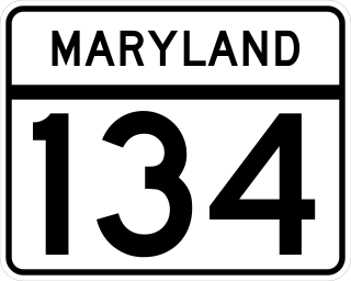
Maryland Route 134 is a signed state highway in the U.S. state of Maryland. Known as Bellona Avenue, the state highway runs 1.63 miles (2.62 km) from MD 139 in Towson north to Ruxton Road in Ruxton in central Baltimore County. MD 134 was created as a modern road from MD 139 northwest to MD 25 in 1928. The highway was reduced to its present length in 1962.

<span class="mw-page-title-main">Maryland Route 25</span> State highway in Maryland, US

Maryland Route 25, locally known for nearly its entire length as Falls Road, is a state highway in the U.S. state of Maryland. It begins north of downtown Baltimore, just north of Penn Station, and continues north through Baltimore County to Beckleysville Road near the Pennsylvania state line. The road passes through the communities of Hampden, Medfield, Cross Keys, and Mount Washington in the city, and Brooklandville and Butler in Baltimore County. The entire length of MD 25 that uses Falls Road—and its county-maintained continuation north to Alesia—is a Maryland Scenic Byway, named the Falls Road Scenic Byway.

Route 51 is a bus route operated by the Maryland Transit Administration in Baltimore and its suburbs. The line currently runs from the center of Towson to the Inner Harbor in Downtown Baltimore, serving the Charles Street corridor. Route 51 replaced Route 11 on June 18, 2017 due to the BaltimoreLink bus system overhaul.

Northern Parkway is a major road that runs west–east across the northern part of the city Baltimore. For most of the way, it is at least six lanes wide, and it is used by motorists for crosstown travel. It is designated E. Northern Pkwy and W. Northern Pkwy with Charles Street being the dividing line. It was constructed in the 1950s through several neighborhoods and several homes were razed in the process from right-of-way. The section of E. Northern Pkwy from Harford Road to Fleetwood Ave was originally called German Lane.

Joppa Road is a county highway in the U.S. state of Maryland. The highway extends 14.3 miles (23.0 km) from Maryland Route 25 in Brooklandville east to MD 7 near White Marsh. Joppa Road has three main segments separated by very short breaks on its course through central and eastern Baltimore County. The central segment is a multi-lane highway from MD 45 and MD 146 in the county seat of Towson to U.S. Route 1 in Perry Hall. This highway is mostly a commercial strip and parallels Interstate 695 (I-695) through Towson, Parkville, and Carney. The western and eastern segments of Joppa Road are two-lane roads through mainly residential areas. The western segment connects Brooklandville and Towson via Riderwood. The eastern segment serves parts of Perry Hall and White Marsh.

Old Court Road is a state- and county-maintained highway in the U.S. state of Maryland. Including the adjacent road in Howard County known as Woodstock Road, the highway runs 15.4 miles (24.8 km) from Maryland Route 99 near Woodstock east to Joppa Road near Towson. Old Court Road includes two county-maintained sections and two Maryland state highways, Maryland Route 125 and Maryland Route 133. MD 125 has a length of 3.59 miles (5.78 km) between Woodstock and the edge of Randallstown and MD 133 spans 3.31 miles (5.33 km) between MD 129 and MD 25 in Pikesville. Old Court Road connects the western and central Baltimore County communities of Granite, Randallstown, Milford Mill, Pikesville, and Towson. Old Court Road has been a cross-county highway since the colonial era. The highway was fully paved in Baltimore County by the mid-1920s, including the sections of the highway that became MD 125 and MD 133. MD 133 was extended west to MD 140 and MD 125 was extended west to MD 99 in the early 1930s; MD 125's terminus returned to the Patapsco River in the mid-1950s. Old Court Road was relocated at its eastern end in the early 1960s and in Pikesville in the late 1960s, at which time MD 133 assumed its current course.

<span class="mw-page-title-main">Brooklandville, Maryland</span> Unincorporated community in Maryland, United States

Brooklandville is an unincorporated community in Baltimore County, Maryland, United States near the intersection of Jones Falls Expressway and the Baltimore Beltway. The general area is a part of Lutherville, and some addresses in the area are considered to be in Lutherville, though Brooklandville has a postal zone and post office of its own. Some notable landmarks in the area, including the Park School of Baltimore and St. Paul's Schools are technically within Brooklandville, as noted by their mailing addresses. However, addresses within the main office complex in the area, Green Spring Station, are considered to be within Lutherville.

<span class="mw-page-title-main">Maryland Route 542</span> State highway in Maryland, United States

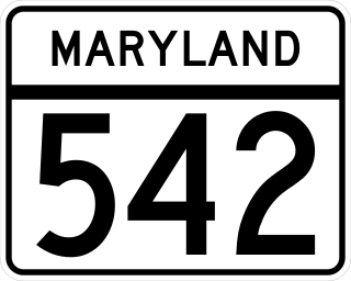
Maryland Route 542 is a state highway in the U.S. state of Maryland. Known for most of its length as Loch Raven Boulevard, the state highway runs 6.33 miles (10.19 km) from MD 147 in Baltimore north to Interstate 695 (I-695) and Cromwell Bridge Road near Towson. MD 542 is a four-lane divided highway that connects portions of Northeast Baltimore with Towson and I-695. The state highway is maintained by the Maryland State Highway Administration in Baltimore County and the Baltimore City Department of Transportation in the city. MD 542 was constructed in the early to mid-1930s. The highway was expanded to a divided highway in Baltimore by 1950 and in Baltimore County in the mid- to late 1950s.

Old Harford Road, one of the oldest continuously used rights-of-way in central Maryland, United States, is a southwest–northeast thoroughfare in northeast Baltimore City and eastern Baltimore County.

<span class="mw-page-title-main">Lake Roland (Maryland)</span> Reservoir in Baltimore County, Maryland

Lake Roland is a 100-acre (0.40 km2) defunct reservoir in Baltimore County, Maryland. It was named for Roland Run, a nearby stream that feeds the lake and eventually flows into Jones Falls. It runs southeast through the city center to the Northwest Branch of the Patapsco River and the Baltimore Harbor. It is located just north of the Baltimore city limits.

<span class="mw-page-title-main">Jones Falls</span> Stream in Maryland

The Jones Falls is a 17.9-mile-long (28.8 km) stream in Maryland. It is impounded to create Lake Roland before running through the city of Baltimore and finally emptying into the Baltimore Inner Harbor.

<span class="mw-page-title-main">LocalLink 33 (BaltimoreLink)</span> Bus route in Baltimore, Maryland and its suburbs

Route 58 is a bus route operated by the Maryland Transit Administration in Baltimore and its suburbs. The line's western terminus is the Reisterstown Plaza Metro Subway Station, and its eastern terminus is White Marsh Mall, though some peak hour trips make short turns in Overlea. Route 58 serves the communities of Glen, Cheswolde, Fallstaff, a large section of Northern Parkway, and a portion of Belair Road in Baltimore County.

<span class="mw-page-title-main">LocalLink 34 (BaltimoreLink)</span> Bus route operated by the Maryland Transit Administration

Route 34 is a bus route operated by the Maryland Transit Administration in Baltimore and its suburbs. The line currently operates weekdays only from the Reisterstown Plaza Metro Subway Station to Stevenson University during peak hours and Greenspring Station midday.

References

  1. History – Ruxton-Riderwood-Lake Roland Area Improvement Association, RRLRAIA, Inc. Retrieved: February 4, 2016.
  2. "Historical Overview". Riderwood, Ruxton, Lake Roland Area Improvement Association. June 22, 2013.
  3. "Historical Overview". Riderwood, Ruxton, Lake Roland Area Improvement Association. June 22, 2013.
  4. "Historical Overview". Riderwood, Ruxton, Lake Roland Area Improvement Association. June 22, 2013.
  5. "National Register Information System". National Register of Historic Places . National Park Service. April 15, 2008.
  6. Daniel Carroll Toomey (1997). Baltimore During the Civil War. Toomey Press. p. 170. ISBN   0-9612670-7-0.
  7. "The Route of Abraham Lincoln's Funeral Train" . Retrieved September 3, 2019.
  8. "Historical Overview". Riderwood, Ruxton, Lake Roland Area Improvement Association. June 22, 2013.
  9. Owens, Gwinn (May 14, 1992). "Down by the station (but not in Ruxton) Light rail opens Sunday without some key stations". Baltimore Sun . Retrieved September 2, 2019.
  10. Film locations for Serial Mom, The Worldwide Guide to Movie Locations. Retrieved: February 4, 2016.
  11. Valley Country Club https://valleycountryclub.com/.{{cite web}}: Missing or empty |title= (help)
  12. Lake Roland Park. Lake Roland Nature Council https://www.lakeroland.org/.{{cite web}}: Missing or empty |title= (help)

39°24′00″N76°38′41″W / 39.40000°N 76.64472°W / 39.40000; -76.64472