
The Inner Harbor is a historic seaport, tourist attraction, and landmark in Baltimore, Maryland. It was described by the Urban Land Institute in 2009 as "the model for post-industrial waterfront redevelopment around the world". The Inner Harbor is located at the mouth of Jones Falls, creating the wide and short northwest branch of the Patapsco River. The district includes any water west of a line drawn between the foot of President Street and the American Visionary Art Museum.

Federal Hill is a neighborhood in Baltimore, Maryland, that lies just to the south of the city's central business district. Many of the structures are included in the Federal Hill Historic District, listed on the National Register of Historic Places in 1970. Other structures are included in the Federal Hill South Historic District, listed in 2003.

Interstate 395 (I-395) is an auxiliary Interstate Highway in the US state of Maryland. Known as Cal Ripken Way, the highway runs 1.98 miles (3.19 km) from I-95 north to Howard Street and Camden Street in Downtown Baltimore, where it provides access to the Inner Harbor and the Baltimore Convention Center. The Interstate also serves the Camden Yards Sports Complex, which contains M&T Bank Stadium and Oriole Park at Camden Yards, homes of the Baltimore Ravens and Baltimore Orioles, respectively. I-395 also serves as the southern terminus of Martin Luther King Jr. Boulevard, an urban arterial that provides a western bypass of Downtown Baltimore and connects I-95 with U.S. Route 40 (US 40), US 1, and I-83. The Interstate is maintained by the Maryland Transportation Authority (MDTA) and, like all Interstates, is a part of the National Highway System.

Mount Vernon is a neighborhood of Baltimore, Maryland, located immediately north of the city's downtown. It is named for George Washington's Mount Vernon estate in Virginia, as the site of the city's Washington Monument.

Pigtown is a neighborhood in the southwest area of Baltimore, bordered by Martin Luther King Jr. Boulevard to the east, Monroe Street to the west, Russell Street to the south, and West Pratt Street to the north. The neighborhood acquired its name during the second half of the 19th century, when the area was the site of butcher shops and meat packing plants to process pigs transported from the Midwest on the B&O Railroad; they were herded across Ostend and Cross Streets to be slaughtered and processed.
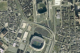
The Camden Yards Sports Complex is located in the center of Baltimore, Maryland. The complex is composed of multiple buildings and stadiums including Oriole Park at Camden Yards and M&T Bank Stadium. The two stadiums are home to the Baltimore Orioles of Major League Baseball and the Baltimore Ravens of the National Football League. The Babe Ruth Birthplace and Museum is located approximately two blocks from the main entrance of Camden Yards at Eutaw Street. The complex also features the original Camden Station which formerly housed the Sports Legends Museum at Camden Yards and Geppi's Entertainment Museum. In addition to the sports facilities, it is also a location for community events such as the Dew Tour's Panasonic Open in June 2007 and 2008, the Baltimore Marathon, and the African American Festival which is held every year.
Ephraim Francis Baldwin was an American architect, best known for his work for the Baltimore and Ohio Railroad and for the Roman Catholic Church.

Charles Street, known for most of its route as Maryland Route 139, runs through Baltimore and the Towson area of Baltimore County. On the north end, it terminates at an intersection with Bellona Avenue near Interstate 695 (I-695). At the south end, it terminates in Federal Hill in Baltimore. Charles Street is one of the major routes through Baltimore, and is a major public transportation corridor. For the one-way portions of Charles Street, the street is functionally complemented by the parallel St. Paul Street, including St. Paul Place and Preston Gardens, Maryland Avenue, Cathedral Street, and Liberty Street.

Westport is a neighborhood in south Baltimore, Maryland. Westport is a majority African-American neighborhood that has struggled with crime, housing abandonment, and unemployment in the past decade. The neighborhood is bordered by the Middle Branch of the Patapsco River on the east, the city neighborhoods of Cherry Hill, Brooklyn and the southwestern Baltimore County community of Lansdowne to the southwest, Hollins Ferry Road and the Mount Winans and Lakeland neighborhoods to the west, and Interstate 95 to the north, along with the South Baltimore communities of Federal Hill and Otterbein. The Baltimore–Washington Parkway runs through the middle of Westport and intersects with Interstate 95, the main East Coast super-highway, north to south, Maine to Florida.

Ridgely's Delight is a historic residential neighborhood in Baltimore, Maryland, United States. Its borders are formed by Russell and Greene Streets to the east, West Pratt Street to the north, and Martin Luther King Jr. Boulevard from the western to southern tips. It is adjacent to the University of Maryland, Baltimore, Oriole Park at Camden Yards, and M&T Bank Stadium. It is situated a short walk from MARC Train and the Light Rail's Camden Station, which has made it a popular residence of Washington, D.C., and suburban Baltimore commuters. It is within a 5-minute walk of both Oriole Park at Camden Yards and M&T Bank Stadium and a 10-minute walk from Baltimore's historic Inner Harbor.

Pratt Street is a major street in Baltimore, Maryland, United States. It forms a one-way pair of streets with Lombard Street that run west–east through downtown Baltimore. For most of their route, Pratt Street is one-way in an eastbound direction, and Lombard Street is one way westbound. Both streets begin in west Baltimore at Frederick Avenue and end in Butcher's Hill at Patterson Park Avenue. Since 2005, these streets have been open to two-way traffic from Broadway until their end at Patterson Park. Although Lombard is also a two-way street from Fulton Avenue to Martin Luther King Jr. Boulevard, Pratt is still one-way eastbound in this area.

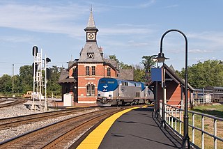
Camden Station, now also referred to as Camden Street Station, Camden Yards, and formally as the Transportation Center at Camden Yards, is a train station at the intersection of South Howard and West Camden Streets in Baltimore, Maryland, adjacent to Oriole Park at Camden Yards, behind the B&O Warehouse. It is served by MARC commuter rail service and local Light Rail trains.
Franklin Street Presbyterian Church and Parsonage is a historic Presbyterian church located at 100 West Franklin Street at Cathedral Street, northwest corner in Baltimore, Maryland, United States. The church is a rectangular Tudor Gothic building dedicated in 1847, with an addition in 1865. The front features two 60 foot flanking octagonal towers are also crenelated and have louvered belfry openings and stained glass Gothic-arched windows. The manse / parsonage at the north end has similar matching walls of brick, heavy Tudor-Gothic window hoods, and battlements atop the roof and was built in 1857.
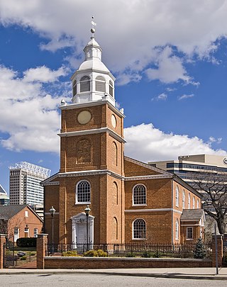
Otterbein Church, now known as Old Otterbein United Methodist Church, is a historic United Brethren church located in Baltimore, Maryland, United States. The first "German Reformed" church was built to serve the German Reformed and some Evangelical Lutheran immigrants, and later entered the Brethren strain of German Reformed Protestantism in the later Church of the United Brethren in Christ.

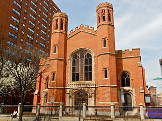
Leadenhall Street Baptist Church is a historic Baptist church located at Baltimore, Maryland, United States. It is a gable-front rectangular brick temple with simple Renaissance Revival detail. The original exterior wall surfaces have been covered with formstone on the main façade and stucco elsewhere. It features round-arched stained glass windows on each side bay. It was built in 1873, by Joseph Thomas & Son for the city's African American Baptists who were then centered in the old southwest area from the downtown business district of Baltimore in the "Sharp-Leadenhall" community in the old "South Baltimore" area. Nearby is its now famed revitalized "Inner Harbor" area of the old "Basin" for the harbor port.

Charles Center is a large-scale urban redevelopment project in central Baltimore's downtown business district of the late 1950s and early 1960s. Beginning in 1954, a group called the "Committee for Downtown" promoted a master plan for arresting the commercial decline of central Baltimore. In 1955, the "Greater Baltimore Committee", headed by banker and developer James W. Rouse, joined the effort. A plan was developed by noted American urban planner and architect David A. Wallace, (1917−2004), strongly supported by Mayors Thomas L. J. D'Alesandro, Jr. (1947−1959) and Theodore R. McKeldin, and many in their administrations, which formed the basis of a $25 million bond issue voted on by the citizens of Baltimore City during the municipal elections in November 1958. The architects' view of the overall Charles Center Redevelopment Plan with the conceptions of possible buildings, lay-out and plan that was publicized to the voters that spring and summer before, only slightly resembles the actual buildings and designs that later were really constructed by the mid-1970s.

Baltimore is the most populous city in the U.S. state of Maryland. With a population of 585,708 at the 2020 census, it is the 30th-most populous city in the United States. Baltimore was designated an independent city by the Constitution of Maryland in 1851, and is currently the most populous independent city in the nation. As of the 2020 census, the population of the Baltimore metropolitan area was 2,838,327, the 20th-largest metropolitan area in the country. When combined with the larger Washington metropolitan area, the Washington–Baltimore combined statistical area (CSA) has a 2020 U.S. census population of 9,973,383, the third-largest in the country.

Hollins Market is a neighborhood in the Sowebo area of Baltimore. It takes its name from the Hollins Market, the oldest public market building still in use in Baltimore City, which is located in the heart of the neighborhood.

Westside Baltimore is the western portion of downtown Baltimore that includes Market Center and many of the newest developments in downtown Baltimore. It has increasingly become the preferred residential section of downtown. It is also home to the site of the "Superblock" project that will include hundreds of condos and apartments as well as a variety of retail and commercial space. The former home of Baltimore's many and famed department stores, Westside Baltimore is now anchored by the University of Maryland, Baltimore consisting of the University of Maryland Health System, University of Maryland School of Law and the University of Maryland Biopark. The Westside is also home to several performing arts centers, including the Hippodrome Theatre, Royal Farms Arena and the future home of the Everyman Theatre.


