Related Research Articles

Mondawmin is a neighborhood located in the city of Baltimore, Maryland, United States. The neighborhood is surrounded by Druid Hill Park, the Whitelock Community, and Lower Park Heights. Included within its boundaries are Frederick Douglass High School, and Mondawmin Mall. The Baltimore Metro Subway serves the neighborhood, with a station at Mondawmin Mall that is also a hub for many bus routes.
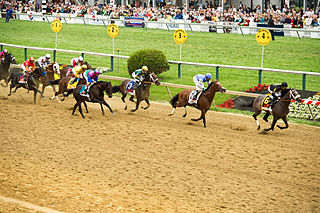
Pimlico is a neighborhood in Baltimore, Maryland. It is the site of Pimlico Race Course, which holds the Preakness Stakes, one of the three legs of the Triple Crown of Thoroughbred Racing. From 1896 through 1915, Pimlico was also the home of Baltimore's Electric Park, a popular amusement park located near the intersection of Reisterstown Road and Belvedere Avenue.
O'Donnell Heights is a neighborhood named for a public housing development in the far southeastern part of the city of Baltimore, Maryland, United States. It is located south and east of Interstate 95, just west of the border with Baltimore County, and north of the St. Helena neighborhood.
Glen is a neighborhood in Baltimore, Maryland. It was developed in the early 1920s and 1930s, with the remaining development coming in the 1940s through the 1960s. Glen is one of the largest communities of Northern Park Heights in Baltimore. Glen is a neighborhood of mixed housing types that include Tudor, French Norman and brick ranch houses, along with garden apartments, condominiums and semi-detached single family homes.
Loch Raven is a neighborhood extending from northeast Baltimore City to the eastern part of Baltimore County, Maryland. The major road in the neighborhood is Loch Raven Boulevard, which stretches all the way from the I-695 beltway in Baltimore County to 25th Street in Baltimore City. It is located in the Baltimore Metro Area, and is considered one of the longest roads in the area with many different aspects of Baltimore that can be seen by riding through the area. This region is a diverse, but predominantly African American part of the city and county, and is also the area that consists of a large amount of Morgan State University students. The zip codes assigned to this area are 21218, 21239, 21286, 21284, and 21234, which is also a Parkville zip code.

Edmondson Village is a neighborhood in the southwestern section of Baltimore, Maryland, encompassing most of the Edmondson Avenue corridor in 21229. The Edmondson Village area is made up of several smaller communities. Its communities include Hunting Ridge, Uplands, Rognel Heights, Wildwood, West Mulberry, Allendale, Edgewood, and Lower Edmondson Village. It is located north of Frederick Avenue, and south of the Gwynns Falls Parkway, Leakin and Gwynns Falls Parks. Communities in the area range from middle class to lower income. A notable shopping center opened in the neighborhood in 1947.
Cedonia is a region of Northeastern Baltimore, Maryland consisting of the neighborhoods of Cedmont, Cedonia, and Frankford. It is located east of Belair Road, above Herring Run Park, and west of the Baltimore City/County Line. It is a predominantly residential area with neighborhoods that range from middle class to lower income.
Forest Park is a region of Northwest Baltimore, Maryland located west of Reisterstown Road, south of Northern Parkway, and east of the Baltimore City/County line. In Baltimore, the region is referred to by locals simply as "Forest Park" and includes the neighborhoods of Ashburton, Callaway-Garrison, Central Forest Park, Dolfield, Dorchester, East Arlington, Forest Park, Grove Park, Hanlon Longwood, Howard Park, Garwyn Oaks, Purnell, West Arlington, West Forest Park, and Windsor Hills.

East Baltimore Midway is a neighborhood in the Eastern district of Baltimore, Maryland. Its boundaries are the south side of 25th Street, the east side of Greenmount Avenue, the west side of Harford Road, and the north side of North Avenue.

Medfield is a neighborhood located in north Baltimore, Maryland, United States of America. It is located to the north of the trendy Hampden neighborhood and south of affluent Roland Park neighborhood. Its unofficial boundaries are Coldspring Lane to the north; Jones Falls Expressway to the west; Falls Road/Hickory Avenue to the east; and West 41st Street to the south.
Rosemont is a neighborhood in the western part of Baltimore, Maryland. Located below North Avenue, above Franklintown Road, East of Hilton Parkway, and West of Bloomingdale Avenue it is a working class African-American neighborhood.

Wilson Park is a small community in northeast Baltimore, Maryland and one of the first African-American communities in the city. Its bounded on the south by 43rd Street and the east by The Alameda. Two community associations serve the area: the Kimberleigh Road Community Association and the Wilson Park Improvement Association. The homes range from large single-family homes to semi-detached and townhouses. A majority of homes are owner-occupied.
Woodbourne Heights, Baltimore is a community in northern Baltimore, Maryland. It is served by the Woodbourne Heights Community, the Woodbourne-McCabe Neighborhood and the Beauregard Neighborhood Associations.

Evergreen is a neighborhood in the North District of Baltimore, Maryland. Evergreen's buildings date from the late 19th to early 20th century. It is known as one of the first early non-rowhouse styled suburban communities in Baltimore.

Wabash Avenue is a six-lane boulevard in northwest Baltimore, Maryland, that runs from Patterson Avenue to Hilton Street, mostly through the Arlington community, crossing over Northern Parkway and Cold Spring Lane along the way. The road starts near the Reisterstown Plaza Metro Subway Station and continues to just past the West Coldspring Metro Subway Station, where it narrows and becomes a one-way pair with Dorithan Road, which ends several blocks later at Hilton Street.
Waltherson is a neighborhood located in Northeast Baltimore, Maryland, United States that runs between Harford Road to Belair Road and from Hamilton Ave in the north and Southern Ave in the south. It was later expanded to include the neighborhood of Wilson Heights extending its boundaries along Belair Road to Moravia Road to achieve the boundaries currently seen on Baltimore City's CityView page.
Gwynn's Falls is a neighborhood in the Southwestern District of Baltimore, located between Irvington (west) and Gwynns Falls Leakin Park (east). Frederick Avenue marks the neighborhood's boundary to the north; Wilkens Avenue draws its southern edge. Caton Avenue separates it from Irvington to the west.
The Orchards is a neighborhood in the North District of Baltimore, located between the neighborhoods of New North Roland Park–Poplar Hill and Bellona–Gittings. Its boundaries are marked by the Baltimore County line (north), Maryland Route 133 Northern Parkway (south), and Maryland Route 139 Charles Street (east). Roland Avenue, West Lake Avenue, Kenmore Road and Melrose Avenue draw the neighborhood's west boundary.

Loyola-Notre Dame is a neighborhood located in Baltimore, Maryland. The neighborhood is named after the two universities that occupy most of the area: Notre Dame of Maryland University and Loyola University Maryland. The neighborhood is also home to the Evergreen House owned by Johns Hopkins University. The neighborhood covers all the area owned by the two universities and Evergreen House. The neighborhood does not cover a uniform area, but does have a relative definition. The northern boundary is Homeland Avenue. The eastern boundary varies among Millbrook Road, Underwood Road and other small streets. The Radnor Village, Thomas Aquinas Hall, and Loyola Public system are also included in the neighborhood despite being separated from the rest of the Loyola campus by the Radnor-Winston and Villages of Homeland neighborhoods. The southern border is Cold Spring Lane and the western border is primarily North Charles Street. Loyola extends via a pedestrian bridge over North Charles Street along Cold Spring Lane to Stony Run stream. The Loyola Fitness and Aquatics center is also across North Charles Street. The neighborhood is unique in having a very small permanent population, but housing over 4,000 students.

The West Baltimore Innovation Village District is a neighborhood district of Baltimore City that will specialize in attracting startup companies and other employers to West Baltimore. Following the Death of Freddie Gray and the subsequent 2015 Baltimore protests, government leaders decided to launch the innovation district as a way to attract redevelopment and revitalization to the areas hardest hit by the protests. The district includes the neighborhoods of Mondawmin, Coppin Heights, Penn-North, Reservoir Hill and Bolton Hill.
References
- ↑ "Taylor Heights". Live Baltimore. Retrieved 2024-02-14.
39°21′59″N76°31′54″W / 39.36639°N 76.53167°W
| | This Baltimore location article is a stub. You can help Wikipedia by expanding it. |