
Fell's Point is a historic waterfront neighborhood in southeastern Baltimore, Maryland. It was established around 1763 along the north shore of the Baltimore Harbor and the Northwest Branch of the Patapsco River. The area has many antique, music, and other stores, restaurants, coffee bars, a municipal markethouse with individual stalls, and over 120 pubs. Located 1.5 miles east of Baltimore's downtown central business district and the Jones Falls stream, Fells Point has a maritime past and the air of a seafaring town. It also has the greatest concentration of drinking establishments and restaurants in the city.
Shawnee is a neighborhood in western Louisville, Kentucky. Its boundaries are the Ohio River on the West, Bank Street and the Portland neighborhood on the North, I-264 on the East, and West Broadway on the South. Maps sometimes identify the area as Shawneeland.

Kensington is a neighborhood in Philadelphia that belongs to Lower Northeast. As with all neighborhoods in the city, the lack of any official designation means the boundaries of the area vary between sources over time and are disputed among locals. Kensington, as most long-term residents view it, refers generally to the area consisting of Kensington, East, or Lower Kensington, West Kensington, and Harrowgate. The adjacent Fairhill and Norris Square neighborhoods are more separate but may be included in Kensington; Fishtown and South (Olde) Kensington were historically included. The most conservative boundaries of the neighborhood, shown in the map below, are Front Street and 5th Street to the west, the Amtrak train tracks to the North, Trenton Avenue, the Trenton Avenue train tracks, and Frankford Avenue to the east, and Cecil B. Moore Avenue to the south.
Columbus, the state capital and Ohio's largest city, has numerous neighborhoods within its city limits. Neighborhood names and boundaries are not officially defined. They may vary or change from time to time due to demographic and economic variables.

Middle East is a neighborhood in the heart of East Baltimore, Maryland.

Two Bridges is a neighborhood in the New York City borough of Manhattan, nestled at the southern end of the Lower East Side and Chinatown on the East River waterfront, near the footings of Brooklyn Bridge and of Manhattan Bridge. The neighborhood has been considered to be a part of the Lower East Side for much of its history. Two Bridges has traditionally been an immigrant neighborhood, previously populated by immigrants from Europe, and more recently from Latin America and China. The Two Bridges Historic District was listed in the National Register of Historic Places in September 2003.
Oliver is a neighborhood in the Eastern district of Baltimore, Maryland. Its boundaries are the south side of North Avenue, the east side of Ensor Street, the west side of Broadway, and the north side of Biddle Street. This neighborhood, adjacent to Johns Hopkins Medical Campus and minutes from the Inner Harbor, lies east of the historic Greenmount Cemetery. The neighborhood is accessible by several bus lines, the Johns Hopkins metro station, Charm City Circulator, Pennsylvania Station (Baltimore), and freeway.

Greenmount West is a neighborhood in the state-designated Station North Arts District of Baltimore City. Its borders consist of Hargrove Alley to the west, Hoffman Street and the Amtrak railroad tracks to the south, the south side of North Avenue to the north, and Greenmount Avenue to the east. Residents in the area include a mix of low, middle and high income families, artists, commuters to Washington DC and working-class Baltimoreans with the majority of residents of African American descent.
Forest Park is a region of Northwest Baltimore, Maryland located west of Reisterstown Road, south of Northern Parkway, and east of the Baltimore City/County line. In Baltimore, the region is referred to by locals simply as "Forest Park" and includes the neighborhoods of Ashburton, Callaway-Garrison, Central Forest Park, Dolfield, Dorchester, East Arlington, Forest Park, Grove Park, Hanlon Longwood, Howard Park, Garwyn Oaks, Purnell, West Arlington, West Forest Park, and Windsor Hills.
The city of San Antonio in the U.S. state of Texas is composed of a number of neighborhoods and districts, spreading out surrounding the central Downtown Area.

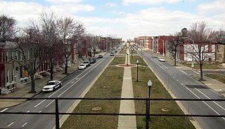
The Coldstream-Homestead-Montebello community, often abbreviated to C-H-M, is a neighbourhood in northeastern Baltimore, Maryland. A portion of the neighborhood has been listed on the National Register of Historic Places as the Coldstream Homestead Montebello Historic District, recognized for the development of a more suburban style of rowhouses.

Barclay is a neighborhood in the center of Baltimore City. Its boundaries, as defined by the City Planning Office, are marked by North Avenue, Greenmount Avenue, Saint Paul and 25th Streets. The neighborhood lies north of Greenmount West, south of Charles Village, west of East Baltimore Midway, and east of Charles North and Old Goucher. The boundary between the Northern and Eastern police districts runs through the community, cutting it roughly in half.

Berea is a neighborhood in the East District of Baltimore. Its boundaries are the south side of Sinclair Lane, the east side of Milton Avenue, the west side of Edison Highway, and the north side of Biddle Street. Berea lies between the neighborhoods of Broadway East (west) and Orangeville (east), north of the Biddle Street neighborhood and south of Four By Four.

East Baltimore Midway is a neighborhood in the Eastern district of Baltimore, Maryland. Its boundaries are the south side of 25th Street, the east side of Greenmount Avenue, the west side of Harford Road, and the north side of North Avenue.

Medfield is a neighborhood located in north Baltimore, Maryland, United States of America. It is located to the north of the trendy Hampden neighborhood and south of affluent Roland Park neighborhood. Its unofficial boundaries are Coldspring Lane to the north; Jones Falls Expressway to the west; Falls Road/Hickory Avenue to the east; and West 41st Street to the south.
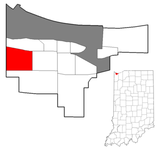
Westside is a neighborhood in west-central Gary, Indiana, USA, bounded by the Cline Avenue expressway on the west, the Norfolk Southern railroad on the north, Clark Road on the east and 25th Avenue on the south. It lies directly east of the Hessville neighborhood of Hammond. Within Gary, it adjoins the neighborhoods of Brunswick, Tolleston and Black Oak. In 2000, Westside had a population of 6,153, which was 63.3% African-American and 31.9% white, with 10.1% Hispanic ethnicity.

Patterson Park is a neighborhood in Baltimore, Maryland, United States. Named for the 137-acre park that abuts its north and east sides, the neighborhood is in the southeast section of Baltimore city, roughly two miles east of Baltimore's downtown district.

The King assassination riots, also known as the Holy Week Uprising, were a wave of civil disturbance which swept across the United States following the assassination of Martin Luther King Jr. on April 4, 1968. Some of the biggest riots took place in Washington, D.C., Baltimore, Chicago, and Kansas City.
The West Side is one of the three major sections of the city of Chicago, Illinois, U.S. The other two sections within Chicago that associate with the West Side are the North Side and the South Side. The West Side consists of communities that are of historical, cultural, and ideological importance to the history and development of Chicago. On the flag of Chicago, the West Side is represented by the central white stripe.

