External links
- Hollins Roundhouse Online
- Union Square Online
- Sowebo Arts Inc.
- The SoWeBo Festival image collection at the Internet Archive
Coordinates: 39°17′15″N76°38′17″W / 39.28750°N 76.63806°W / 39.28750; -76.63806
Sowebo (South West Baltimore) is a community-chosen name for a historic area in the South West of Baltimore City.
Sowebo encompasses the neighborhoods of Union Square and Hollins Market, Baltimore. At one point, the area suffered from decades of urban decay but, in recent years, this community has seen increasing gentrification. On its main thoroughfares, West Lombard Street, Hollins Street, West Baltimore Street and South Carey Streets, spacious three-story row houses predominate. Most are pre- and post-Civil War Italianate in style, but there are many examples of Early Victorian Greek Revival and Late Victorian Romanesque Revival . A majority of these homes have ten- to fourteen-foot ceilings, tall distinctive windows, wood floors, and plaster walls. Exteriors are brick and mortar facades with cornices and marble steps. On side streets and alley streets (which are common in Baltimore) a variety of two-story and two-story-with-attic rowhouses are found.
An uncommon synergy prevails in Sowebo as residents, both longtime and newly arrived, work together through various committees and forums to enhance the area's quality of life . An annual arts festival, called the Sowebohemian Arts Festival, is held in the streets around Hollins Market on the Sunday afternoon of the Memorial Day weekend.
The University of Maryland's BioPark is a recent addition, with portions still under construction. The state-of-the-art facility contrasts greatly with historic Sowebo, which is listed on the National Register of Historic Places (The Union Square/Hollins Market District ), as is the H.L. Mencken house , which is located in the neighborhood at 1524 Hollins Street.
Photographer Martha Cooper moved back to her hometown of Baltimore in 2006 and bought a home close to Hollins Market from the artist John Ellsberry where she has become the unofficial "community photographer" for Sowebo. She launched her project with $3,300 of state funds granted through the nonprofit housing organization Southwest Visions. The photo project, with or without more funding, could continue for the rest of her working life, she says.
Coordinates: 39°17′15″N76°38′17″W / 39.28750°N 76.63806°W
| | This Baltimore location article is a stub. You can help Wikipedia by expanding it. |

Victorian architecture is a series of architectural revival styles in the mid-to-late 19th century. Victorian refers to the reign of Queen Victoria (1837–1901), called the Victorian era, during which period the styles known as Victorian were used in construction. However, many elements of what is typically termed "Victorian" architecture did not become popular until later in Victoria's reign, roughly from 1850 and later. The styles often included interpretations and eclectic revivals of historic styles (see Historicism). The name represents the British and French custom of naming architectural styles for a reigning monarch. Within this naming and classification scheme, it followed Georgian architecture and later Regency architecture, and was succeeded by Edwardian architecture.

Wooster Square is a neighborhood in the city of New Haven, Connecticut to the east of downtown. The name refers to a park square located between Greene Street, Wooster Place, Chapel Street and Academy Street in the center of the neighborhood. Wooster Square is also known as Little Italy: a bastion of Italian American culture and cuisine, and is home to some of New Haven's, best-known pizza eateries, including Frank Pepe Pizzeria Napoletana and Sally's Apizza. The square and much of the neighborhood are included in the Wooster Square Historic District, which was listed on the National Register of Historic Places in 1971.

Fell's Point is a historic waterfront neighborhood in southeastern Baltimore, Maryland, United States. It was established around 1763 and is located along the north shore of the Baltimore Harbor and the Northwest Branch of the Patapsco River. The area has many antique, music and other stores, restaurants, coffee bars, a municipal markethouse with individual stalls, and over 120 pubs. Located 1.5 miles east of Baltimore's downtown central business district and the Jones Falls stream, Fells Point has a maritime past and the air of a seafaring town. It also has the greatest concentration of drinking establishments and restaurants in the city.

West Adams is a historic neighborhood in the South Los Angeles region of Los Angeles, California. The area is known for its large number of historic buildings, structures and notable houses and mansions throughout Los Angeles. It is a youthful, densely populated area with a high percentage of African American and Latino residents. The neighborhood has several public and private schools.

Downtown Phoenix is the central business district (CBD) of the City of Phoenix, Arizona, United States. It is located in the heart of the Phoenix metropolitan area or Valley of the Sun. Phoenix, being the county seat of Maricopa County and the capital of Arizona, serves as the center of politics, justice and government on the local, state and federal levels. The area is a major center of employment for the region, with many financial, legal, and other national and international corporations housed in a variety of skyscrapers. Major arts and cultural institutions also call the area home. Downtown Phoenix is a center of major league sports activities, live concert events, and is an equally prominent center of banking and finance in Arizona. Regional headquarters for several major banks, including JP Morgan Chase, Wells Fargo, US Bank, Bank of America, Compass Bank and Midfirst Bank are all located within or close proximity to the area.

Mount Vernon is a neighborhood immediately north of downtown Baltimore, Maryland. Designated a National Historic Landmark District and a city Cultural District, it is one of the city's oldest neighborhoods and originally was home to the city's wealthiest and most fashionable families. The name derives from the Mount Vernon home of George Washington; the original Washington Monument, a massive pillar commenced in 1815 to commemorate the first president of the United States, is the defining feature of the neighborhood.

Over-the-Rhine is a neighborhood in Cincinnati, Ohio, United States. Historically, Over-the-Rhine has been a working-class neighborhood. It is among the largest, most intact urban historic districts in the United States.

Victorian Village is a neighborhood in Columbus, Ohio, United States, north and near west of downtown. It is an established neighborhood built when a streetcar line first ran along Neil Avenue around 1900 with a fair number of established trees for an urban setting. To preserve, protect and enhance the unique architectural and historical features, the Victorian Village Historic District was established in 1973. Columbus Monthly named this neighborhood the top place to live for Arts and Entertainment, with fun right around the corner in the Short North as its neighborhood hangout.

West Philadelphia, nicknamed West Philly, is a section of Philadelphia, Pennsylvania. Though there is no official definition of its boundaries, it is generally considered to reach from the western shore of the Schuylkill River, to City Avenue to the northwest, Cobbs Creek to the southwest, and the SEPTA Media/Elwyn Line to the south. An alternate definition includes all city land west of the Schuylkill; this would also include Southwest Philadelphia and its neighborhoods. The eastern side of West Philadelphia is also known as University City.

Lansdowne is a census-designated place in southern Baltimore County, Maryland, United States, located just south of Baltimore city. As of the 2010 census, it had a population of 8,409. At the 2000 census and earlier, the area was delineated as part of the Lansdowne-Baltimore Highlands CDP.

Mondawmin is a neighborhood located in the city of Baltimore, Maryland, United States. The neighborhood is surrounded by Druid Hill Park, the Whitelock Community, and Lower Park Heights. Included within its boundaries are Frederick Douglass High School, and Mondawmin Mall. The Baltimore Metro Subway serves the neighborhood, with a station at Mondawmin Mall that is also a hub for many bus routes.

Union Square is a neighborhood located in the Sowebo area of Baltimore. It dates to the 1830s and includes a historic district of houses and commerce buildings.
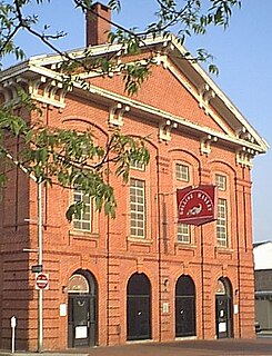
Hollins Market is the name of the oldest existing public market building in the city of Baltimore, Maryland. It is a contributing property to the Union Square-Hollins Market Historic District.

Middle East is a neighborhood in the heart of East Baltimore, Maryland.

Greenmount West is a neighborhood in the state-designated Station North Arts District of Baltimore City. Its borders consist of Hargrove Alley to the west, Hoffman Street and the Amtrak railroad tracks to the south, the south side of North Avenue to the north, and Greenmount Avenue to the east. Residents in the area include a mix of low, middle and high income families, artists, commuters to Washington DC and working-class Baltimoreans with the majority of residents of African American descent.

The community of Wyman Park is a border community that links Hampden to Roland Park. All of the Wyman Park areas were annexed to Baltimore City in 1888. The general boundaries consist of the area from south to north between 33rd Street and 40th Streets and west to east from Keswick Road to Wyman Park. South of 40th Street, garden apartments, multi-story apartment buildings, and single-family residences have been built. People here tend to relate to the north along 40th Street and University Parkway and The Johns Hopkins University. The Wyman Park also accommodates the Union Soldiers and Sailors Monument, located at 29th and Charles Street, and the now removed Stonewall Jackson and Robert E. Lee Monument that has been rededicated as Harriet Tubman Grove on Art Museum Drive.

"Mount Winans" is a mixed-use residential, commercial and industrial neighborhood in the southwestern area of the City of Baltimore in Maryland. Its north, south and east boundaries are marked by the various lines of track of the CSX Railroad. In addition, Hollins Ferry Road running to the south towards suburban Baltimore County in the southwest and further connecting with adjacent Anne Arundel County to the southeast, draws its western boundary.
Lakeland is a neighborhood in south Baltimore, Maryland. Its borders are Annapolis Road on the east, the Baltimore city/county line to the south, a CSX/MARC Railroad line to the west, and the same railroad line to the north.
Hollins Market is a neighborhood in the Sowebo area of Baltimore. It takes its name from the Hollins Market, the oldest public market building still in use in Baltimore City, which is located in the heart of the neighborhood.

Milton-Montford is a neighborhood in the heart of East Baltimore, Maryland. Milton-Montford lies north of Patterson Park and south of Amtrak's Northeast Corridor. The neighborhood is bounded by the neighborhoods of McElderry Park to the south, Madison-Eastend to the east, Biddle Street to the north, and Middle East to the west. The swath of land between Johns Hopkins Hospital and Frank C Bocek Park, which includes Milton-Montford, is often referred to as the "Down the Hill" neighborhood by local residents.