Related Research Articles

Cherry Hill is one of the southernmost neighborhoods in Baltimore, Maryland.

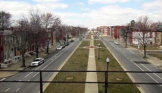
Upton is a neighborhood in Baltimore City, Maryland, United States. The neighborhood is in the western section of the city, roughly between Fremont Avenue and McCulloh Street, extending from Dolphin Street to Bloom Street. Its principal thoroughfare is Pennsylvania Avenue.

Kresson is a neighborhood of Southeast Baltimore, Maryland, United States.
Carrollton Ridge is a neighborhood of South Baltimore, Maryland, United States
Morrell Park is a neighborhood located in southwest Baltimore, Maryland, United States.
O'Donnell Heights is a neighborhood named for a public housing development in the far southeastern part of the city of Baltimore, Maryland, United States. It is located south and east of Interstate 95, just west of the border with Baltimore County, and north of the St. Helena neighborhood.
St Helena is the southeasternmost neighborhood in the city of Baltimore, Maryland. St. Helena is a neighborhood within the community of Dundalk. The Baltimore City/Baltimore County boundary line runs through St. Helena. So, St. Helena is located in both Baltimore County and Baltimore City. It has a mix of rowhouses and detached homes. It is divided by railroad tracks from the Point Breeze Industrial Park.

Johns Hopkins Bayview Medical Center, located in southeast Baltimore City, Maryland, U.S., is a hospital and medical office center within the Johns Hopkins Health System.
Oliver is a neighborhood in the Eastern district of Baltimore, Maryland. Its boundaries are the south side of North Avenue, the east side of Ensor Street, the west side of Broadway, and the north side of Biddle Street. This neighborhood, adjacent to Johns Hopkins Medical Campus and minutes from the Inner Harbor, lies east of the historic Greenmount Cemetery. The neighborhood is accessible by several bus lines, the Johns Hopkins metro station, Charm City Circulator, Pennsylvania Station (Baltimore), and freeway.

Edmondson Village is a neighborhood in the southwestern section of Baltimore, Maryland, encompassing most of the Edmondson Avenue corridor in 21229. The Edmondson Village area is made up of several smaller communities. Its communities include Hunting Ridge, Uplands, Rognel Heights, Wildwood, West Mulberry, Allendale, Edgewood, and Lower Edmondson Village. It is located north of Frederick Avenue, and south of the Gwynns Falls Parkway, Leakin and Gwynns Falls Parks. Communities in the area range from middle class to lower income. A notable shopping center opened in the neighborhood in 1947.
Coppin Heights is a neighborhood in the western part of Baltimore, Maryland. Located above North Avenue, it is a working-class neighborhood home to Coppin State University.

Forest Park is a region of Northwest Baltimore, Maryland located west of Reisterstown Road, south of Northern Parkway, and east of the Baltimore City/County line. In Baltimore, the region is referred to by locals simply as "Forest Park" and includes the neighborhoods of Ashburton, Callaway-Garrison, Central Forest Park, Dolfield, Dorchester, East Arlington, Forest Park, Grove Park, Hanlon Longwood, Howard Park, Garwyn Oaks, Purnell, West Arlington, West Forest Park, and Windsor Hills.
St. Paul Street and Calvert Street are a one-way pair of streets in Downtown Baltimore and areas north. The streets, which are part of Maryland Route 2, are two of Baltimore's best-known streets in the downtown area.
Mid-Govans is a community in northeast Baltimore, Maryland and part of the development of York Road, a historic Baltimore route to Pennsylvania. As the name suggests, Mid-Govans is located in the center of the larger neighborhood, Govans, with the rough boundaries of York Road to the west, Belvedere Avenue to the north, Midwood Avenue to the east, and Woodbourne Avenue to the south.

Gwynn's Falls is a neighborhood in the Southwestern District of Baltimore, located between Irvington (west) and Gwynns Falls Leakin Park (east). Frederick Avenue marks the neighborhood's boundary to the north; Wilkens Avenue draws its southern edge. Caton Avenue separates it from Irvington to the west.
The Orchards is a neighborhood in the North District of Baltimore, located between the neighborhoods of New North Roland Park–Poplar Hill and Bellona–Gittings. Its boundaries are marked by the Baltimore County line (north), Maryland Route 133 Northern Parkway (south), and Maryland Route 139 Charles Street (east). Roland Avenue, West Lake Avenue, Kenmore Road and Melrose Avenue draw the neighborhood's west boundary.
Orchard Ridge, Baltimore is a neighborhood in the Northeastern part of Baltimore, Maryland, United States. It was formerly known as Claremont-Freedom. The neighborhood was redeveloped as a mixed tenancy, mixed-income community with 461 units. It includes both rental and homeownership townhouses, semi-detached homes, apartments and a community center.

Bromo Arts District is one of three designated arts district in Baltimore, MD and is centered around the Emerson Bromo-Seltzer Tower, which houses artist studios. The district is roughly bounded by Park Avenue on the east, Lombard Street on the south, Paca Street on the west and Martin Luther King Jr. Boulevard and Read Street on the north and is adjacent to the neighborhoods of Mount Vernon and downtown Baltimore. It is home to the University of Maryland Medical Center, Lexington Market, Westminster Hall and Edgar Allan Poe's gravesite, the former Martick's Restaurant Francais and many cultural institutions including the Hippodrome Theatre, the Everyman Theatre, and the Eubie Blake National Jazz and Cultural Center. It is also home to A.T. Jones and Sons, the oldest costume company in the United States.

The West Baltimore Innovation Village District is a neighborhood district of Baltimore City that will specialize in attracting startup companies and other employers to West Baltimore. Following the Death of Freddie Gray and the subsequent 2015 Baltimore protests, government leaders decided to launch the innovation district as a way to attract redevelopment and revitalization to the areas hardest hit by the protests. The district includes the neighborhoods of Mondawmin, Coppin Heights, Penn-North, Reservoir Hill and Bolton Hill.
References
Coordinates: 39°17′27″N76°39′5″W / 39.29083°N 76.65139°W
| This article about a location in Baltimore City, Maryland is a stub. You can help Wikipedia by expanding it. |