
Riverdale Park, formerly known and often referred to as Riverdale, is a semi-urban town in Prince George's County, Maryland, United States, a suburb in the Washington, D.C. metropolitan area. The population was 6,955 as of the 2010 U.S. Census. The population as of 2019 is approximately 7,304, according to the US Census Bureau and other entities.

Hampden is a neighborhood located in northern Baltimore, Maryland, United States. Roughly triangular in shape, it is bounded to the east by the neighborhood Wyman Park, to the north by Roland Park at 40th and 41st Street, to the west by the Jones Falls Expressway, and to the south by the neighborhood Remington. The Homewood campus of the Johns Hopkins University is a short distance to the east.

Druid Hill Park is a 745-acre (3.01 km2) urban park in northwest Baltimore, Maryland. Its boundaries are marked by Druid Park Drive (north), Swann Drive and Reisterstown Road, and the Jones Falls Expressway / Interstate 83 (east).

Canton is a historic waterfront neighborhood in Baltimore, Maryland, United States. The neighborhood is along Baltimore's outer harbor in the southeastern section of the city, roughly two miles east of Baltimore's downtown district and next to or near the neighborhoods of Patterson Park, Fell's Point, Highlandtown, and Brewers Hill.
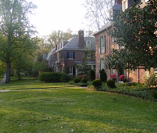
Roland Park is a community located in Baltimore, Maryland. It was developed between 1890 and 1920 as an upper-class streetcar suburb. The early phases of the neighborhood were designed by Edward Bouton and Frederick Law Olmsted, Jr.

Roland Park Country School (RPCS) is an independent all-girls college preparatory school in Baltimore, Maryland, United States. It serves girls from Kindergarten through Grade 12. It is located on Roland Avenue in the northern area of Baltimore called Roland Park. An August 2010 Baltimore Magazine article cites RPCS as the "best school for tomorrow’s leaders."
Ruxton and Riderwood are unincorporated communities in Baltimore County, Maryland, United States. They are sometimes considered a part of Towson and are part of Towson's census area.

Abell is a neighborhood located in the north-central area of Baltimore, Maryland, United States. It is considered to be part of Charles Village, Baltimore.

Hamilton Hills is a mixed-use suburban neighborhood located in the northeastern corner of Baltimore City, Maryland. Hamilton Hills represents a section of Hamilton, a larger historic area that includes other neighborhoods in Northeast Baltimore. The neighborhood's borders are Old Harford Road and Harford Road to the east, Echodale Avenue to the south, Perring Parkway to the west and the Baltimore County line to the north. The main thoroughfare in Hamilton Hills is Harford Road, which has been an integral part of the area's history.

Charles Street, known for most of its route as Maryland Route 139, runs through Baltimore City and through the Towson area of Baltimore County. On the north end it terminates at an intersection with Bellona Avenue near Interstate 695 (I-695) and at the south end it terminates in Federal Hill in Baltimore. Charles Street is one of the major routes through the city of Baltimore, and is a major public transportation corridor. For the one-way portions of Charles Street, the street is functionally complemented by the parallel St. Paul Street, Maryland Avenue, Cathedral Street, and Liberty Street.
Northern Parkway is a major road that runs west–east across the northern part of the city Baltimore. For most of the way, it is at least six lanes wide, and it is used by motorists for crosstown travel. It is designated E. Northern Pkwy and W. Northern Pkwy with Charles Street being the dividing line. It was constructed in the 1950s through several neighborhoods and several homes were razed in the process from right-of-way. The section of E. Northern Pkwy from Harford Road to Fleetwood Ave was originally called German Lane.

Clifton Park is a public urban park and national historic district located between the Coldstream-Homestead-Montebello and Waverly neighborhoods to the west and the Belair-Edison, Lauraville, Hamilton communities to the north in the northeast section of Baltimore, Maryland, United States. It is roughly bordered by Erdman Avenue to the northeast, Sinclair Lane to the south, Harford Road to the northwest and Belair Road to the southeast. The eighteen-hole Clifton Park Golf Course, which is the site of the annual Clifton Park Golf Tournament, occupies the north side of the park.

Medfield is a neighborhood located in north Baltimore, Maryland, United States of America. It is located to the north of the trendy Hampden neighborhood and south of affluent Roland Park neighborhood. Its unofficial boundaries are Coldspring Lane to the north; Jones Falls Expressway to the west; Falls Road/Hickory Avenue to the east; and West 41st Street to the south.

Lauraville is a neighborhood in northeast Baltimore, Maryland. The neighborhood is bounded on the east by Harford Road, on the north by Echodale Avenue, on the south by Argonne Drive and Herring Run Park, and on the west side by Morgan Park and Morgan State University, with East Cold Spring Lane passing through the center of Lauraville.
Guilford is a prominent and historic neighborhood located in the northern part of Baltimore, Maryland. It is bounded on the south by University Parkway, on the west by North Charles Street, Warrenton and Linkwood Roads, on the north by Cold Spring Lane and on the east by York Road. The neighborhood is adjacent to the neighborhoods of Tuscany-Canterbury, Loyola-Notre Dame, Kernewood, Wilson Park, Pen Lucy, Waverly Oakenshawe, Charles Village, and the universities of Johns Hopkins and Loyola University Maryland. The neighborhood was added to the National Register of Historic Places in 2001.

Ednor Gardens-Lakeside is a large community in northeast Baltimore, Maryland. It is bounded by 33rd Street to the south, Hillen Road to the east, Ellerslie Avenue to the west, and Argonne Drive, The Alameda, Loch Raven Boulevard, and Roundhill Road to the north. Ednor Gardens was part of a large planned community that was built out from the 1920s through the 1950s by Edward Gallagher, one of Baltimore's most prolific homebuilders at the time. It is notable among its neighbors for the quality of the homes and extensive landscaping. Until it was torn down in 2002, Memorial Stadium was located in Ednor Gardens-Lakeside.

Lake Roland is a 100-acre (0.40 km2) defunct reservoir in Baltimore County, Maryland. It was named for Roland Run, a nearby stream that feeds the lake and eventually flows into Jones Falls. It runs southeast through the city center to the Northwest Branch of the Patapsco River and the Baltimore Harbor. It is located just north of the Baltimore city limits.
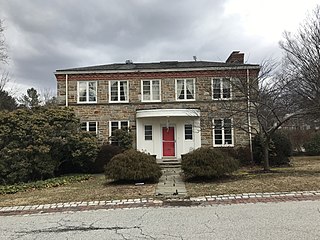
The Orchards is a neighborhood in the North District of Baltimore, located between the neighborhoods of New North Roland Park–Poplar Hill and Bellona–Gittings. Its boundaries are marked by the Baltimore County line (north), Maryland Route 133 Northern Parkway (south), and Maryland Route 139 Charles Street (east). Roland Avenue, West Lake Avenue, Kenmore Road and Melrose Avenue draw the neighborhood's west boundary.

Patterson Park is a neighborhood in Baltimore, Maryland, United States. Named for the 137-acre park that abuts its north and east sides, the neighborhood is in the southeast section of Baltimore city, roughly two miles east of Baltimore's downtown district.
