Urban renewal is a program of land redevelopment often used to address urban decay in cities. Urban renewal is the clearing out of blighted areas in inner cities to clear out slums and create opportunities for higher class housing, businesses, and more. A primary purpose of urban renewal is to restore economic viability to a given area by attracting external private and public investment and by encouraging business start-ups and survival.

Wilde Lake is a man-made drainage reservoir dug in 1966 and also named after the surrounding "village" of neighborhoods located in Columbia, Maryland, just north and west of Columbia Town Center. The village was the first part of Columbia's "New Town" to be built in the late 1960s, James W. Rouse and Frazar B. Wilde formally opened the neighborhood on June 21, 1967. The lake and village are named for Frazar B. Wilde, a past chairman of the board of Connecticut General Life Insurance Company and former employer of James Rouse. In 1963, the company agreed to fund the secret land purchases and, in return, acquired an equity participation. This arrangement was subsequently formalized by the creation of The Howard Research and Development Corporation, the joint venture established to develop Columbia.

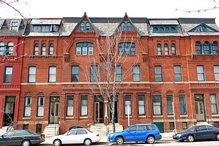
Charles Village is a neighborhood located in the north-central area of Baltimore, Maryland, USA. It is a middle-class area with many single-family homes that is in proximity to many of Baltimore's urban amenities. The neighborhood began in 1869 when 50 acres (200,000 m2) of land were purchased for development. The land was divided and turned over to various builders who constructed home exteriors, leaving the interiors to be custom built according to buyer specifications. The area was first developed as a streetcar suburb in the early 20th century, and is thought to be the first community to employ tract housing tactics. At the time, the area was known as Peabody Heights; the moniker Charles Village, derived from Charles Street, the area's major north–south corridor, was coined in the 1970s as the beginning of a process of conceptually grouping a large and somewhat heterogeneous area. The neighborhood history has been researched and published by Gregory J. Alexander and Paul K. Williams in their book Charles Village: A Brief History.
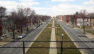
The Station North Arts and Entertainment District is an area and official arts and entertainment district in the U.S. city of Baltimore, Maryland. The neighborhood is marked by a combination of artistically-leaning commercial ventures, such as theaters and museums, as well as formerly abandoned warehouses that have since been converted into loft-style living. It is roughly triangular, bounded on the north by 20th Street, on the east by Greenmount Avenue, and on the south and west by the tracks of Amtrak's Northeast Corridor, though the neighborhood's boundaries include a one-block wide extension over the tracks.

Abell is a neighborhood located in the north-central area of Baltimore, Maryland, United States. It is considered to be part of Charles Village, Baltimore.
The term "sustainable communities" has various definitions, but in essence refers to communities planned, built, or modified to promote sustainable living. Sustainable communities tend to focus on environmental and economic sustainability, urban infrastructure, social equity, and municipal government. The term is sometimes used synonymously with "green cities," "eco-communities," "livable cities" and "sustainable cities."
The University District, is a 2.8-square-mile (7.3 km2) area located 2 miles (3.2 km) north of Downtown Columbus, Ohio that is home to the main campus of The Ohio State University, the Battelle Institute, and the Arthur G. James Cancer Hospital and Richard J. Solove Research Institute. It is generally accepted as the area bounded to the north by Clintonville at Glen Echo Ravine; to the south by the Short North at 5th Avenue; to the west by the Olentangy River and to east by the ConRail railroad tracks. Points of interest include, but are not limited to, the Ohio Stadium and Old North Columbus. The district is Columbus' most densely populated area and contains more than 650 businesses, human service agencies, churches, and schools. University District businesses include boutiques, mixed retail, several tattoo studios, the Landmark Gateway theater, and a diverse range of restaurants and bars.

Middle East is a neighborhood in the heart of East Baltimore, Maryland.
Oliver is a neighborhood in the Eastern district of Baltimore, Maryland. Its boundaries are the south side of North Avenue, the east side of Ensor Street, the west side of Broadway, and the north side of Biddle Street. This neighborhood, adjacent to Johns Hopkins Medical Campus and minutes from the Inner Harbor, lies east of the historic Greenmount Cemetery. The neighborhood is accessible by several bus lines, the Johns Hopkins metro station, Charm City Circulator, Pennsylvania Station (Baltimore), and freeway.

Greenmount West is a neighborhood in the state-designated Station North Arts District of Baltimore City. Its borders consist of Hargrove Alley to the west, Hoffman Street and the Amtrak railroad tracks to the south, the south side of North Avenue to the north, and Greenmount Avenue to the east. Residents in the area include a mix of low, middle and high income families, artists, commuters to Washington DC and working-class Baltimoreans with the majority of residents of African American descent.
Planning and development in Detroit since the late 20th century has attempted to enhance the economy and quality of life of Detroit, Michigan, United States. In 1970, the private group Detroit Renaissance began to facilitate development in the city. Its successor, Business Leaders for Michigan, has continued to facilitate development into the 21st century. Projects have included new commercial facilities, revitalization of neighborhoods, hospitality infrastructure, and improvements to recreational and public facilities, such as the QLine light rail project.

Columbia Point, in the Dorchester neighborhood of Boston, Massachusetts sits on a peninsula jutting out from the mainland of eastern Dorchester into the bay. Old Harbor Park is on the north side, adjacent to Old Harbor, part of Dorchester Bay. The peninsula is primarily occupied by Harbor Point, the University of Massachusetts Boston, the John F. Kennedy Presidential Library and Museum, the Edward M. Kennedy Institute for the United States Senate, and a complex at the former Bayside Expo Center, Boston College High School, and the Massachusetts Archives. The Boston Harborwalk follows the entire coastline.
East Baltimore Midway is a neighborhood in the Eastern district of Baltimore, Maryland. Its boundaries are the south side of 25th Street, the east side of Greenmount Avenue, the west side of Harford Road, and the north side of North Avenue.

Pen Lucy is a small community in the North District of Baltimore and part of the development of York Road, a historic Baltimore route to Pennsylvania. The Pen Lucy neighborhood features many different housing types. The neighborhood is bounded by Argonne Drive (south), East 43rd Street (north), Greenmount Avenue (west) and The Alameda (east). The Pen Lucy Neighborhood Association, Inc., a non profit community organization represents the residents of the Pen Lucy Community.

The Midway area, also called the North Bay area, is a neighborhood of San Diego, California. It is located at the northern (mainland) end of the Point Loma peninsula, northwest of Downtown San Diego and just west of Old Town. It is often considered to be part of Point Loma, although the city treats it as a separate Planning Area.

Land recycling is the reuse of abandoned, vacant, or underused properties for redevelopment or repurposing.

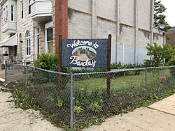
Harwood is a small neighborhood located in the north-central area of Baltimore, Maryland, USA. It sits east of Charles Village, south of Abell, west of Waverly and north of Barclay. Its boundaries are Guilford and Greenmount Avenues to the east and west, and 25th and 29th streets to the north and south. These streets together encompass about 14 city blocks.
Teachers Village is a neighborhood centered around Halsey Street in Newark, New Jersey. It is located in Downtown Newark in southwest quadrant of the Four Corners Historic District, south of Market Street (SoMa) in the Central Ward between the Prudential Center and Springfield/Belmont.