Hampden is a neighborhood located in northern Baltimore, Maryland, United States. Roughly triangular in shape, it is bounded to the east by the neighborhood Wyman Park, to the north by Roland Park at 40th and 41st Street, to the west by the Jones Falls Expressway, and to the south by the neighborhood Remington. The Homewood campus of the Johns Hopkins University is a short distance to the east.

Cherry Hill is one of the southernmost neighborhoods in Baltimore, Maryland.
Ruxton and Riderwood are unincorporated communities in Baltimore County, Maryland, United States. They are sometimes considered a part of Towson and are part of Towson's census area.

Otterbein is a small neighborhood of historic rowhouses in Baltimore, Maryland, United States. Otterbein is immediately southwest of, and in close walking distance to, the Inner Harbor. The neighborhood is very compact, entirely located between Hanover Street and Sharp Street, and between Barre Street and Henrietta Street. It is in small parts of zip codes 21201 and 21230. It is named for Old Otterbein Church, located immediately north of the neighborhood.
St. Paul Street and Calvert Street are a one-way pair of streets in Downtown Baltimore and areas north. The streets, which are part of Maryland Route 2, are two of Baltimore's best-known streets in the downtown area.

Medfield is a neighborhood located in north Baltimore, Maryland, United States of America. It is located to the north of the trendy Hampden neighborhood and south of affluent Roland Park neighborhood. Its unofficial boundaries are Coldspring Lane to the north; Jones Falls Expressway to the west; Falls Road/Hickory Avenue to the east; and West 41st Street to the south.

Lake Roland is a 100-acre (0.40 km2) defunct reservoir in Baltimore County, Maryland. It was named for Roland Run, a nearby stream that feeds the lake and eventually flows into Jones Falls. It runs southeast through the city center to the Northwest Branch of the Patapsco River and the Baltimore Harbor. It is located just north of the Baltimore city limits.

The Jones Falls is a 17.9-mile-long (28.8 km) stream in Maryland. It is impounded to create Lake Roland before running through the city of Baltimore and finally emptying into the Baltimore Inner Harbor.

Evergreen is a neighborhood in the North District of Baltimore, Maryland. Evergreen's buildings date from the late 19th to early 20th century. It is known as one of the first early non-rowhouse styled suburban communities in Baltimore.
Keswick is a residential neighborhood in Baltimore, Maryland. The area is mostly surrounded by, and sometimes considered a part of, the Roland Park neighborhood. It also borders the Evergreen neighborhood to the north and Guilford to the east. Keswick is delineated as south of West Cold Spring Lane, east of Kittery Lane, north of Overhill Road, and west of Stony Run stream.

Wyndhurst is a neighborhood located in the North District of Baltimore, Maryland.
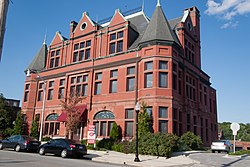
The Rotunda is a mixed-use property in northern Baltimore, Maryland in the popular neighborhood of Hampden, adjacent to the neighborhoods of Roland Park, and Wyman Park and near the campus of the Johns Hopkins University. The property features retail, office, and residential components including: 150,000 ft² of retail space, 140,000 ft² of office space, 379 apartments and over 1100 off-street parking spaces, including a multi-level parking garage featuring several electric car charging stations.

Remington is a neighborhood in northern Baltimore bordered to the north by Hampden, Wyman Park, and Johns Hopkins University and to the east by Charles Village. The southernmost boundary is North Avenue and the long southwestern boundary is formed by Falls Road in the I-83 corridor. The neighborhood is split between two Baltimore City Council Districts.

The Homewood Campus is the main academic and administrative center of the Johns Hopkins University. It is located at 3400 North Charles Street in Baltimore, Maryland. It houses the two major undergraduate schools: the Zanvyl Krieger School of Arts and Sciences and the Whiting School of Engineering.
The Orchards is a neighborhood in the North District of Baltimore, located between the neighborhoods of New North Roland Park–Poplar Hill and Bellona–Gittings. Its boundaries are marked by the Baltimore County line (north), Maryland Route 133 Northern Parkway (south), and Maryland Route 139 Charles Street (east). Roland Avenue, West Lake Avenue, Kenmore Road and Melrose Avenue draw the neighborhood's west boundary.

Harwood is a small neighborhood located in the north-central area of Baltimore, Maryland, USA. It sits east of Charles Village, south of Abell, west of Waverly and north of Barclay. Its boundaries are Guilford and Greenmount Avenues to the east and west, and 25th and 29th streets to the north and south. These streets together encompass about 14 city blocks.

The Savage Mill Trail is a 0.8-mile (1.3 km) rail trail that winds along the Little Patuxent River in Savage, Maryland. The trail was formerly part of the Baltimore and Ohio Railroad's rail corridor through central Maryland, but the Howard County Recreation and Parks Department acquired the land in 1978.

Loyola-Notre Dame is a neighborhood located in Baltimore, Maryland. The neighborhood is named after the two universities that occupy most of the area: Notre Dame of Maryland University and Loyola University Maryland. The neighborhood is also home to the Evergreen House owned by Johns Hopkins University. The neighborhood covers all the area owned by the two universities and Evergreen House. The neighborhood does not cover a uniform area, but does have a relative definition. The northern boundary is Homeland Avenue. The eastern boundary varies among Millbrook Road, Underwood Road and other small streets. The Radnor Village, Thomas Aquinas Hall, and Loyola Public system are also included in the neighborhood despite being separated from the rest of the Loyola campus by the Radnor-Winston and Villages of Homeland neighborhoods. The southern border is Cold Spring Lane and the western border is primarily North Charles Street. Loyola extends via a pedestrian bridge over North Charles Street along Cold Spring Lane to Stony Run stream. The Loyola Fitness and Aquatics center is also across North Charles Street. The neighborhood is unique in having a very small permanent population, but housing over 4,000 students.
Stony Run is a tributary stream of Jones Falls in Baltimore, Maryland. The stream headwaters are in north Baltimore near the city boundary. The stream flows southward about 3 miles (4.8 km) through several park areas - including Friends School of Baltimore-and the neighborhood of Wyman Park, and enters a culvert before emptying into Jones Falls near Druid Hill Park.