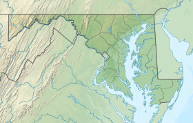
Essex is an unincorporated community and census-designated place in Baltimore County, Maryland, United States. Essex has a long history dating back to 1909. The population was 40,505 in the 2020 census, up from 39,262 in the 2010 census.

Seneca Creek State Park is a public recreation area encompassing more than 6,300 acres (2,500 ha) along 14 miles of Seneca Creek in its run to the Potomac River in Montgomery County, Maryland. The park features facilities for boating and fishing as well as trails for hiking, cycling, and horseback riding. It is managed by the Maryland Department of Natural Resources.

William Penn State Forest is a Pennsylvania State Forest in Pennsylvania Bureau of Forestry District #17. The main offices are located in Elverson in Chester County, Pennsylvania in the United States.

Tiadaghton State Forest is a Pennsylvania State Forest in the Pennsylvania Department of Conservation and Natural Resources, Bureau of Forestry. The forest is primarily in western and southern Lycoming County, with small portions in Clinton, Potter, Tioga, and Union Counties. The district's topography consists of narrow, flat to sloping plateaus cut by deep, steep-sloped valleys carved by fast moving mountain streams, including Pine Creek, Slate Run, and their tributaries. The Tiadaghton district extends south across the lowland along the west branch of the Susquehanna River to the narrow crests of Bald Eagle Mountain and North and South White Deer Ridge. The majority of forest cover is dominated by mixed oak forests, with some areas of northern hardwoods. The Tiadaghton State Forest is one of eight forest districts in the Pennsylvania Wilds region.
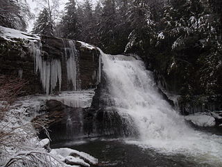
Swallow Falls State Park is a public recreation area located on the west bank of the Youghiogheny River nine miles (14 km) northwest of Oakland in Garrett County, Maryland, in the United States. The state park features Maryland's highest free-falling waterfall, the 53-foot (16 m) Muddy Creek Falls, as well as smaller waterfalls on the Youghiogheny River and Tolivar Creek. The park is notable for its stand of old hemlock trees, some more than 300 years old, "the last stand of its kind in Maryland."

Assateague State Park is a public recreation area in Worcester County, Maryland, located at the north end of Assateague Island, a barrier island bordered by the Atlantic Ocean on the east and Sinepuxent Bay on the west. The state park is bordered on both its north and south sides by Assateague Island National Seashore and is reached via the Verrazano Bridge which carries Maryland Route 611 across Sinepuxent Bay. The park offers wildlife viewing, beach activities, and camping facilities. It is managed by the Maryland Park Service of the larger Maryland Department of Natural Resources with the support of volunteers working under the auspices of the non-profit Friends of Assateague State Park.

Susquehanna State Park is a public recreation area located on the banks of the lower Susquehanna River north of the city of Havre de Grace, Maryland. The state park's main area is on the west bank of the river; the park also manages land on the river islands and east bank. The park offers fishing, boating, camping, and trails for hiking and equestrian use. It is managed as a complex with Rocks State Park and Palmer State Park by the Maryland Department of Natural Resources.
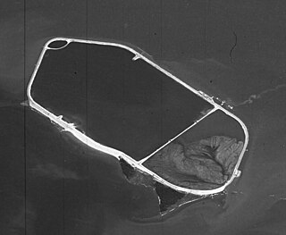
Hart Miller Island is located at the mouths of Back River and Middle River, where they empty into the Chesapeake Bay east of the City of Baltimore in Maryland. It was formerly two separate islands, Hart Island and Miller Island, but it is now almost entirely artificial. In 1981, the area began being filled with dredged material by the U.S. Army Corps of Engineers, for the purpose of habitat restoration, and the project is scheduled for completion in 2012. It is now in use as Hart-Miller Island State Park, accessible only by boat.

Cunningham Falls State Park is a public recreation area located west of Thurmont, Maryland, in the United States. The state park is the home of Cunningham Falls, the largest cascading waterfall in Maryland, a 43-acre (17 ha) man-made lake, and the remains of a historic iron furnace. The park is one of several protected areas occupying 50-mile-long Catoctin Mountain; it is bordered on its north by Catoctin Mountain Park and on its south by Frederick Municipal Forest.

Elk Neck State Park is a public recreation area located between Chesapeake Bay and the Elk River near the southern tip of the Elk Neck Peninsula in Cecil County, Maryland. The state park is home to the historic Turkey Point Light and offers land-based and water-based recreation. The park is located on MD 272, eight miles (13 km) south of the town of North East, and 13 miles (21 km) south of exit 100 on I-95. It is operated by the Maryland Department of Natural Resources.

Rocks State Park is a public recreation area located in and around Deer Creek Valley near Pylesville, Harford County, Maryland. The state park's 1,060 acres (430 ha) preserve the geologic formation known as the King and Queen's Seat and other features in three non-contiguous areas near the junction of Maryland Route 24 and Maryland Route 165. It is managed by the Maryland Department of Natural Resources.
Gunpowder Falls State Park is a public recreation area comprising six non-contiguous areas covering 18,000 acres (7,300 ha) in northeastern Baltimore County and western Harford County, Maryland. The state park is primarily made up of the stream valleys of the Big and Little Gunpowder Falls and the Gunpowder River; its natural features range from tidal marshes to rugged interior slopes. The park has over 120 miles of trails for hiking, biking, horseback riding, and cross-country skiing plus facilities for picnicking, tubing, canoeing and kayaking, tide-water fishing and crabbing, fly fishing, and hunting, among other activities. It is managed by the Maryland Department of Natural Resources.

Poplar Island is a 3-mile-long (4.8-kilometer-long) island located on the Chesapeake Bay, part of Talbot County, Maryland. In the late 1800s it had a population of 100 living in the town of Valliant but it was abandoned by the 1920s due to erosion of the island. By the 1990s its land mass had dwindled down to a few acres. In 2001, a project led by the U.S. Army Corps of Engineers to restore the island began using dredged material from the Chesapeake Bay's approach channels to Baltimore, located approximately 30 miles north/north-west of the island.

Greenbrier State Park is a public recreation area located on South Mountain, three miles (4.8 km) northeast of Boonsboro in Washington County, Maryland, USA. The state park has camping, hiking trails, and a 42-acre (17 ha) man-made lake. It is managed by the Maryland Department of Natural Resources.
Palmer State Park is a public recreation area located along Deer Creek two miles southwest of Dublin in Harford County, Maryland. The state park saw its genesis in 1965, when Gerald and Ruth Palmer donated 463 acres for use as a public park. The park's historic industrial sites include remnants of the Husband Flint Mill and Deer Creek Iron Works. The heavily forested area is open to canoeing, fishing, and hiking.

Purse State Park is a former Maryland state park located on the Potomac River in Charles County that has been subsumed into the 1,365-acre (552 ha) Nanjemoy Wildlife Management Area. As the Purse Area, the former park is known for fossil hunting on the beaches of Wades Bay at the southern end of the Nanjemoy WMA. Fossil discoveries have included shark teeth and Cibicides.
St. Mary's River State Park is a public recreation area located in St. Mary's County, Maryland. The state park consists of two sites: one encompasses 250-acre (100 ha) St. Mary's Lake ; the second covers 2,200 acres (890 ha) and is largely undeveloped. The park is managed by the Maryland Department of Natural Resources.

Pointe Mouillee State Game Area (; pointmoo-yay or is a state game area in the U.S. state of Michigan. It encompasses 7,483 acres of hunting, recreational, and protected wildlife and wetland areas at the mouth of the Huron River at Lake Erie, as well as smaller outlying areas within the Detroit River. Pointe Mouillee State Game Area was established in 1945 and is administered by the Michigan Department of Natural Resources.