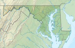
Carroll County is located in the U.S. state of Maryland. As of the 2020 census, the population was 172,891. Its county seat is Westminster.

Mount Airy is a town in Carroll and Frederick counties in the U.S. state of Maryland. It is part of both the Washington Metropolitan Area and Baltimore Metropolitan Area. As of the 2010 census the population was 9,288.

The Patuxent River is a tributary of the Chesapeake Bay in the state of Maryland. There are three main river drainages for central Maryland: the Potomac River to the west passing through Washington, D.C., the Patapsco River to the northeast passing through Baltimore, and the Patuxent River between the two. The 908-square-mile (2,352 km2) Patuxent watershed had a rapidly growing population of 590,769 in 2000. It is the largest and longest river entirely within Maryland, and its watershed is the largest completely within the state.

The Cannon River a tributary of the Mississippi River flows 112 miles (180 km) from Shields Lake near Shieldsville to Red Wing in the U.S. state of Minnesota, where it joins the Mississippi River. It drains a watershed approximately 1460 square miles (3,780 km²) in size. The river flows through the counties of Le Sueur, Rice, Dakota, and Goodhue.

The Patapsco River mainstem is a 39-mile (63 km) river in central Maryland that flows into the Chesapeake Bay. The river's tidal portion forms the harbor for the city of Baltimore. With its South Branch, the Patapsco forms the northern border of Howard County, Maryland. The name "Patapsco" is derived from the Algonquian pota-psk-ut, which translates to "backwater" or "tide covered with froth."

Finksburg is an unincorporated community in Carroll County, Maryland, United States. It is the location of the National Security Agency's EKMS Central Facility. Finksburg is located at the intersection of Maryland Routes 91 and 140, on the border of Carroll and Baltimore counties. It is an unincorporated area approximately one mile northwest of the Liberty Reservoir and six miles southeast of Westminster. It is also mentioned in Season 3 Episode 8 of mayday.

Jennings Randolph Lake is a reservoir of 952 acres (3.85 km2) located on the North Branch Potomac River in Garrett County, Maryland and Mineral County, West Virginia. It is approximately 8 miles (13 km) upstream of Bloomington, Maryland, and approximately 5 miles (8.0 km) north of Elk Garden, West Virginia.

Prettyboy Reservoir is a 1,500-acre (610 ha) reservoir in northern Baltimore County, Maryland, also known as the Hereford Zone. Even though the reservoir is in the county, the City of Baltimore owns the reservoir and the surrounding land of forested watershed. The reservoir is one of three reservoirs created to supply the Metropolitan Baltimore municipal water system for Baltimore City, Baltimore County and northern Anne Arundel County constructed by the Baltimore City Department of Public Works. Prettyboy Reservoir, along with Loch Raven Reservoir that is downstream of the Gunpowder Falls, provide about 61% of the drinking water for the Baltimore Metropolitan system. For this reason, the Prettyboy is considered a "source water" or drinking water watershed. The reservoir on average contains about 19 billion US gallons (72,000,000 m3) of water.

Woodbine is an unincorporated rural community in Howard and Carroll counties, Maryland, United States. It is part of the Baltimorean metropolitan area. It is located southeast of Frederick, west of Baltimore, north of Washington, D.C., and east of Mount Airy. The community was named for the woodbine plant, which grew in the community in fields and along riverbanks.

Maryland Route 26 is a state highway in the U.S. state of Maryland. Known for most of its length as Liberty Road, the state highway runs 44.10 miles (70.97 km) from U.S. Route 15 in Frederick east to MD 140 in Baltimore. MD 26 connects Frederick and Baltimore with the highway's namesake of Libertytown in eastern Frederick County, the suburban area of Eldersburg in southern Carroll County, and the western Baltimore County suburbs of Randallstown, Milford Mill, and Lochearn. The highway also serves as a major thoroughfare in the western part of Baltimore, where the street is named Liberty Heights Avenue. MD 26 is maintained by the Maryland State Highway Administration outside of Baltimore and by the Baltimore City Department of Transportation within the city.

Bloede's Dam was a hydroelectric dam on the Patapsco River in Maryland. Built in 1906, it was the first submerged hydroelectric plant—that is, the power plant was housed under the spillway. It was also one of the earliest dams constructed of reinforced concrete. The dam was demolished in 2018 and its site is now part of Patapsco Valley State Park Avalon Area.

Patapsco Valley State Park is a Maryland state park extending along 32 miles (51 km) of the Patapsco River south and west of the city of Baltimore, Maryland. The park encompasses multiple developed areas on over 14,000 acres (5,700 ha) acres of land, making it Maryland's largest state park. In 2006, it was officially celebrated as Maryland's first state park, its first formation being in 1906. Patapsco Valley State Park is managed by the Maryland Department of Natural Resources.

Little Falls Branch, a 3.8-mile-long (6.1 km) tributary stream of the Potomac River, is located in Montgomery County, Maryland. In the 19th century, the stream was also called Powder Mill Branch. It drains portions of Bethesda, Somerset, Friendship Heights, and Washington, D.C., flows under the Chesapeake and Ohio Canal (C&O), and empties into the Potomac at Little Falls rapids, which marks the upper end of the tidal Potomac.
The Loch Raven Reservoir is a reservoir that provides drinking water for the City of Baltimore and most of Baltimore County, Maryland. It is fed by the Big Gunpowder Falls river, and has a capacity of 23 billion US gallons (87,000,000 m3) of water.
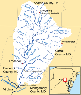
Double Pipe Creek, sometimes called Pipe Creek, is a major tributary of the Monocacy River in Carroll County and Frederick County in Maryland, located several miles north and west of Westminster. The creek is only 1.6 miles (2.6 km) long, but is formed by the confluence of two much longer streams, Big Pipe Creek and Little Pipe Creek.

Gwynns Falls is a 24.9-mile-long (40.1 km) stream located in Baltimore County and Baltimore City, Maryland. Its headwaters are located in Reisterstown in Baltimore County, and the stream flows southeast, entering the city of Baltimore and emptying into the Middle Branch of the Patapsco River. The Patapsco drains into the Chesapeake Bay. The watershed area of Gwynns Falls covers 66 square miles (170 km2), with 133 miles (214 km) of streams.
Piney Run Park is a nature park in Sykesville, located in Carroll County, Maryland. It is Carroll County's oldest developed park and hosts thousands of visitors annually. The park encompasses 550 acres of fields, forest and open spaces, features over 15 miles of hiking trails, a 300-acre lake and many sports and recreational facilities. Prior to being a park, this land was a private farm.
The Orange Grove Flour Mill was a flour mill established in 1856. It was one of the leading flour mills in the Mid-Atlantic states until it was destroyed in a fire in 1905.

The Patapsco Valley is a small valley surrounding the Patapsco River in central Maryland. The region is known for its historical significance as a major economic and industrial center in the eighteenth and nineteenth centuries.
A proposed Union Mills Reservoir represents a half century of efforts by the Commissioners of the Carroll County, Maryland, to build variations on a "dam" or "reservoir" near Union Mills, Maryland, on the Big Pipe Creek, defeated by a petition led by the Carroll County Taxpayers' Committee in the 1970s. The plan may be alive among some county officials but may also be postponed "indefinitely." Land threatened by the reservoir includes the Whittaker Chambers Farm, also known as the Pipe Creek Farm, a National Historic Landmark as well as protected under the Maryland Agricultural Land Preservation Foundation (MALPF).