
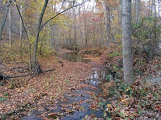
The Monocacy River is a free-flowing left tributary to the Potomac River, which empties into the Atlantic Ocean via the Chesapeake Bay. The river is 58.5 miles (94.1 km) long, with a drainage area of about 744 square miles (1,930 km2). It is the largest Maryland tributary to the Potomac.

Antietam Creek is a 41.7-mile-long (67.1 km) tributary of the Potomac River located in south central Pennsylvania and western Maryland in the United States, a region known as the Hagerstown Valley. The creek became famous as a focal point of the Battle of Antietam during the American Civil War.

Seneca Creek is a 5.8-mile-long (9.3 km) stream in Montgomery County, Maryland, USA, roughly 16 miles (26 km) northwest of Washington, D.C. It drains into the Potomac River.

Catoctin Creek is a 27.9-mile-long (44.9 km) tributary of the Potomac River in Frederick County, Maryland, USA. Its source is formed in the Myersville, Maryland area and flows directly south for the entire length of the stream. Catoctin Creek enters the Potomac River east of Brunswick. The stream flows through Catoctin Creek Park.
Little Conococheague Creek is a 12.4-mile-long (20.0 km) tributary stream of the Potomac River in the U.S. states of Maryland and Pennsylvania. The stream rises on Two Top Mountain, west of the Whitetail Ski Resort in Franklin County, Pennsylvania, and proceeds south into Washington County, Maryland. It empties into the Potomac about 2 miles (3 km) southeast of Big Spring, Maryland. The watershed of the creek is 18 square miles (47 km2) and includes Indian Springs Wildlife Management Area. Tributaries include Toms Run.
Cabin John Creek is a tributary stream of the Potomac River in Montgomery County, Maryland. The watershed covers an area of 26 square miles (67 km2). The headwaters of the creek originate in the city of Rockville, and the creek flows southward for 10.9 miles (17.5 km) to the Potomac River.
Carroll Creek is an 8.3-mile-long (13.4 km) tributary of the Monocacy River in Frederick County, Maryland. The headwaters of the creek are located on the eastern slopes of Catoctin Mountain, southeast of Gambrill State Park. The stream runs roughly east through the city of Frederick to the Monocacy, which drains to the Potomac River. The Shawnee Indians, who called the Monocacy River Monnockkesey, named Carroll Creek Walkwaki Methtegui,.

Little Falls Branch, a 3.8-mile-long (6.1 km) tributary stream of the Potomac River, is located in Montgomery County, Maryland. In the 19th century, the stream was also called Powder Mill Branch. It drains portions of Bethesda, Somerset, Friendship Heights, and the District of Columbia, flows under the Chesapeake and Ohio Canal (C&O), and empties into the Potomac at Little Falls rapids, which marks the upper end of the tidal Potomac.

Paint Branch is a 14.0-mile-long (22.5 km) stream that flows through Montgomery County and Prince George's County, Maryland. It is a tributary of the Northeast Branch, which flows to the Anacostia River, Potomac River and the Chesapeake Bay.
Rock Run is a tributary stream of the Potomac River in Montgomery County, Maryland. The headwaters of the stream rise in the village of Potomac, and the creek flows southeast for 5.3 miles (8.5 km) to the Potomac River.
Hawlings River is a 12.9-mile-long (20.8 km) tributary of the Patuxent River in Montgomery County, Maryland. The watershed covers an area of about 28 square miles (73 km2). The headwaters of the river originate in the area north of Laytonsville, and the river flows southeast, entering the Patuxent about 1.5 miles (2.4 km) below the Triadelphia Reservoir. Portions of Hawlings River flow through Rachel Carson Conservation Park and Hawlings River Stream Valley Park. Tributaries of the Hawlings River include Mount Zion Tributary, Reddy Branch, Olney Mill Tributary, Gregg Tributary, and James Creek. The river and its tributaries total about 98 miles (158 km) of streams.
Broad Run is a tributary stream of the Potomac River in Montgomery County, Maryland. The headwaters of the stream originate west of the town of Poolesville, and the creek flows southward for 8.9 miles (14.3 km) to the Potomac River. The Broad Run and its watershed are almost entirely within the Montgomery County Agricultural Reserve.
Ballenger Creek is a 10.7-mile-long (17.2 km) tributary of the Monocacy River in Frederick County, Maryland. The headwaters of the creek are located on the east slope of Catoctin Mountain, about 3 miles (5 km) west of the city of Frederick. The stream runs roughly southeast to the Monocacy National Battlefield and the confluence with the Monocacy River, which drains to the Potomac River. The watershed area of the creek is 21.8 square miles (56 km2).
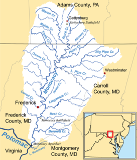
Linganore Creek is a 13.5-mile-long (21.7 km) tributary of the Monocacy River in Frederick County, Maryland. The stream is formed from the confluence of the north and south forks of the Linganore, about 10 miles (16 km) east-northeast of the city of Frederick. The creek runs roughly southwest to the Monocacy River, which drains to the Potomac River. The watershed area of the creek is 83.1 square miles (215 km2). High water in the creek can result in flooding of Gas House Pike, an east-west road running between Monocacy Boulevard and Green Valley Road.

Little Seneca Creek is an 14.0-mile-long (22.5 km) stream in Montgomery County, Maryland, roughly 18 miles (29 km) northwest of Washington, D.C.
Muddy Branch is a tributary stream of the Potomac River in Montgomery County, Maryland, United States, located about 14 miles (23 km) northwest of Washington, D.C.
Double Pipe Creek, sometimes called Pipe Creek, is a major tributary of the Monocacy River in Carroll County and Frederick County in Maryland, located several miles north and west of Westminster. The creek is only 1.6 miles (2.6 km) long, but is formed by the confluence of two much longer streams, Big Pipe Creek and Little Pipe Creek.
Tuscarora Creek is a 7.7-mile-long (12.4 km) tributary of the Monocacy River in Frederick County, Maryland, in the United States.

Tuscarora Creek is a 12.8-mile-long (20.6 km) tributary of the Potomac River in Frederick County, Maryland, in the United States.

Tenmile Creek is a tributary stream of Little Seneca Creek in Montgomery County, Maryland.


