Colonial Beach, Virginia (CBVA) is a river and beach town located in the northwestern part of Westmoreland County on Virginia's Northern Neck peninsula. It is bounded by the Potomac River, Monroe Bay and Monroe Creek and home to the second-largest beachfront in the state. It is located 65 mi (105 km) from Washington, D.C., and 70 mi (110 km) from the state capital Richmond and 35 nautical miles from the Chesapeake Bay.

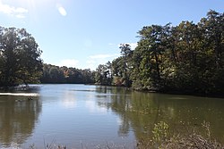
The Severn River is a tidal estuary 14 miles (23 km) long, located in Anne Arundel County in the U.S. state of Maryland, south of the Magothy River and north of the South River.
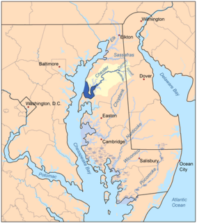
The Chester River is a major tributary of the Chesapeake Bay on the Delmarva Peninsula. It is about 43 miles (69 km) long, and its watershed encompasses 368 sq mi (950 km2), which includes 295 sq mi (760 km2) of land. Thus the total watershed area is 20% water. It forms the border between Kent County and Queen Anne's County, Maryland, with its headwaters extending into New Castle County and Kent County, Delaware. Chestertown, the seat of Maryland's Kent County, is located on its north shore. It is located south of the Sassafras River and north of Eastern Bay, and is connected with Eastern Bay through Kent Narrows.
The Wicomico River is a 13.0-mile-long (20.9 km) tributary of the lower tidal portion of the Potomac River located in the U.S. state of Maryland south of Washington, DC. The river empties into the Potomac at Cobb Island and St. Margaret's Island. Its watershed area is 77 square miles (200 km2), with 2% impervious surface in 1994. in Charles, St. Mary's, and southern Prince George's counties. The lower section of the river forms part of the boundary between Charles and St. Mary's counties. The Wicomico River was designated a Scenic River under the Maryland Scenic River Act in 1968, and there are Scenic River Commissions for it in both Charles and St. Mary's counties.
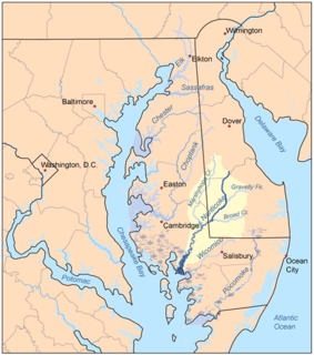
The Nanticoke River is a tributary of the Chesapeake Bay on the Delmarva Peninsula. It rises in southern Kent County, Delaware, flows through Sussex County, Delaware, and forms the boundary between Dorchester County, Maryland and Wicomico County, Maryland. The tidal river course proceeds southwest into the Tangier Sound, Chesapeake Bay. The river is 64.3 miles (103.5 km) long. A 26-mile ecotourism water trail running along the River was set aside in July 2011 by Delaware state and federal officials, contiguous with a 37-mile water-trail extending through Maryland to the Chesapeake Bay.
The South River is a 10-mile-long (16 km) tributary of the Chesapeake Bay in Anne Arundel County, Maryland in the United States. It lies south of the Severn River, east of the Patuxent River, and north of the West River and Rhode River, and drains to the Chesapeake Bay.
Conowingo Creek is a 20.2-mile-long (32.5 km) tributary of the Susquehanna River in Lancaster County, Pennsylvania and Cecil County, Maryland.

Conewago Creek is an 80.2-mile-long (129.1 km) tributary of the Susquehanna River in Adams and York counties in Pennsylvania in the United States, with its watershed also draining a small portion of Carroll County, Maryland. The source is at an elevation of 1,440 feet (440 m), east of Caledonia State Park, in Franklin Township in Adams County. The mouth is the confluence with the Susquehanna River at York Haven in York County at an elevation of 259 feet (79 m).
Codorus Creek is a 42.4-mile-long (68.2 km) tributary of the Susquehanna River in York County, Pennsylvania in the United States.
The Rhode River is a 3-mile-long (5 km) tidal tributary of the West River in Anne Arundel County, Maryland. It is south of the South River.
Popes Creek is a 3.4-mile-long (5.5 km) stream in Charles County, Maryland and a tributary of the Potomac River.
Lyons Creek is an 11.2-mile-long (18.0 km) tributary of the Patuxent River in Maryland. Lyons Creek serves as the borider between southern Anne Arundel County, Maryland and northern Calvert County, Maryland.

Paint Branch is a 14.0-mile-long (22.5 km) stream that flows through Montgomery County and Prince George's County, Maryland. It is a tributary of the Northeast Branch, which flows to the Anacostia River, Potomac River and the Chesapeake Bay.
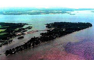
Slaughter Creek is a 6.7-mile-long (10.8 km) saltwater creek that drains into the Little Choptank River. The creek is 0.3 miles (0.5 km) wide at its mouth. It separates Taylors Island, Maryland from the mainland.
The St. Martin River is a tributary of Isle of Wight Bay in Worcester County, Maryland. Approximately 4.4 miles (7.1 km) long, it drains the northernmost part of Worcester County.
Beachville-St. Inigoes is an unincorporated community in St. Mary's County, Maryland, United States. Located here is Webster Field, a branch of the larger Patuxent River Naval Air Station.
The West River is a 6-mile-long (9.7 km) tidal tributary of Chesapeake Bay in southern Anne Arundel County, Maryland. It is south of the Rhode River, which is one of its tributaries, and north of Herring Bay.
Middle River is an estuary in Baltimore County, Maryland, located about 5 miles (8 km) east of the city of Baltimore. The estuary extends from the community of Middle River, north of the Martin Plaza Shopping Center, to the southeast for about 4 miles (6.4 km), to the Chesapeake Bay. The watershed area of Middle River is 12 square miles (31 km2), and includes Martin State Airport.
Town Creek is a tributary of the Tred Avon River in Talbot County on Maryland's Eastern Shore.
Town Creek is a tributary of the Patuxent River in Saint Mary's County, Maryland.