
Rockville is a city that serves as the county seat of Montgomery County, Maryland, United States, and is part of the Baltimore–Washington metropolitan area. The 2020 census tabulated Rockville's population at 67,117, making it the fourth-largest community in Maryland.

Anne Arundel County, also notated as AA or A.A. County, is located in the U.S. state of Maryland. As of the 2020 United States census, its population was 588,261, an increase of just under 10% since 2010. Its county seat is Annapolis, which is also the capital of the state. The county is named for Anne Arundell, Lady Baltimore, a member of the ancient family of Arundells in Cornwall, England, and the wife of Cecilius Calvert, 2nd Baron Baltimore (1605–1675), founder and first lord proprietor of the colony Province of Maryland.
St. Mary's County, established in 1637, is a county located in the U.S. state of Maryland. As of the 2020 census, the population was 113,777. Its county seat is Leonardtown. The name is in honor of Mary, the mother of Jesus. St. Mary's County comprises the California-Lexington Park, Maryland Metropolitan Statistical Area, which also is included in the Washington-Baltimore-Arlington, DC-MD-VA-WV-PA Combined Statistical Area. It is part of the Southern Maryland region. The county was the home to the first Maryland Colony, and the first capital of the Colony of Maryland. Settled by English Catholics, it is considered to be the birthplace of religious freedom in North America, at a time when the British colonies were settled primarily by Protestants. The county is home to the Patuxent River Naval Air Station and St. Mary's College of Maryland. Traditionally, St. Mary's County has been known for its unique and historic culture of Chesapeake Bay tidewater farming, fishing, and crabbing communities. But with the advent of the military bases, growth of an extensive defense contractor presence, and the growth of St. Mary's College of Maryland, as well as increasing numbers of long-distance Washington, D.C. commuters, it has been undergoing a decades-long transformation which has seen the county's population double since 1970.

Glacier County is located in the U.S. state of Montana. As of the 2020 census, the population was 13,778. The county is located in northwestern Montana between the Great Plains and the Rocky Mountains, known to the Blackfeet as the "Backbone of the World". The county is geographically and culturally diverse and includes the Blackfeet Indian Reservation, Glacier National Park, and Lewis and Clark National Forest. The county is bordered by 75 miles of international boundary with two ports of entry open year-round and one seasonal international border crossing into Alberta, Canada.

Woodlawn is an unincorporated community and census-designated place in Baltimore County, Maryland. Per the 2020 census, the population was 39,986. It is home to the headquarters of the Social Security Administration (SSA) and the Centers for Medicare and Medicaid Services (CMS). It is bordered by Catonsville on the south, by the Patapsco River and Howard County on the west, by Randallstown and Lochearn to the north, and by the City of Baltimore to the east. Parts of Woodlawn are sometimes informally referred to as Security, Maryland, due to the importance of the SSA's headquarters as well as nearby Security Boulevard and Security Square Mall.

Adelphi is an unincorporated area and census-designated place in Prince George's County, Maryland, United States. Per the 2020 Census, the population was 16,823. Adelphi includes the following subdivisions; Adelphi, Adelphi Park, Adelphi Hills, Adelphi Terrace, Adelphi Village, Buck Lodge, Chatham, Cool Spring Terrace, Hillandale Forest, Holly Hill Manor, Knollwood, Lewisdale, and White Oak Manor.

Laurel is a city in Maryland, United States, located midway between Washington, D.C. and Baltimore on the banks of the Patuxent River. While the city limits are entirely in northern Prince George's County, outlying developments extend into Anne Arundel, Montgomery and Howard counties. Founded as a mill town in the early 19th century, Laurel expanded local industry and was later able to become an early commuter town for Washington and Baltimore workers following the arrival of the Baltimore and Ohio Railroad in 1835. Largely residential today, the city maintains a historic district centered on its Main Street, highlighting its industrial past.

Lexington Park is a census-designated place (CDP) in St. Mary's County, Maryland, United States, and the principal community of the Lexington Park, Maryland Micropolitan Statistical Area. The population was 11,626 at the 2010 census.
St. Mary's City is a former colonial town that was Maryland's first European settlement and capital. It is now a large, state-run historic area, which includes a reconstruction of the original colonial settlement, and a living history area and museum complex. Half of the area is occupied by the campus of the public honors college, St. Mary's College of Maryland. The area also contains a community of about 933 residents.

Southern Maryland is a geographical, cultural and historic region in Maryland composed of the state's southernmost counties on the Western Shore of the Chesapeake Bay. According to the state of Maryland, the region includes all of Calvert, Charles, and St. Mary's counties and the southern portions of Anne Arundel and Prince George's counties. It is largely coterminous with the region of Maryland that is part of the Washington metropolitan area.

Millersville is an unincorporated community in Anne Arundel County, Maryland, United States. Population was 20,965 in 2015 based on American Community Survey data.
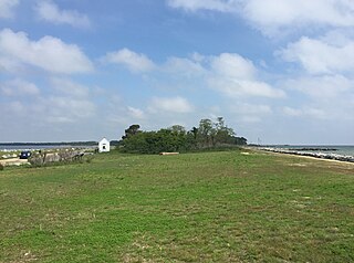
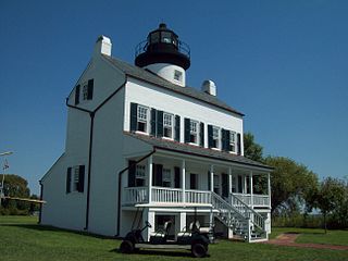
Point Lookout State Park is a public recreation area and historic preserve occupying Point Lookout, the southernmost tip of a peninsula formed by the confluence of Chesapeake Bay and the Potomac River in St. Mary's County, Maryland. The state park preserves the site of an American Civil War prisoner of war camp and the Point Lookout Light, which was built in 1830. It is the southernmost spot on Maryland's western shore, the coastal region on the western side of the Chesapeake Bay.

Leonardtown High School is a comprehensive public high school in Leonardtown, Maryland, United States, for students in grades 9–12. It offers college preparatory programs and programs that prepare students for business and technical occupations. It serves the community in the central portion of St. Mary's County, Maryland, between the Potomac River and Patuxent River. The area is a mixture of rural and suburban communities. Many of the families are employed by NAS Patuxent River, government contractors, St. Mary's College of Maryland, St Mary's County government and others involved in the traditional agriculture and water related businesses.

Great Mills High School is a comprehensive public high school in Great Mills, Maryland, United States. It serves students in grades 9–12 in the mixed rural and suburban area at the confluence of the Potomac River, Patuxent River, and Chesapeake Bay. It belongs to the St. Mary's County Public Schools system, and is associated with two other county high schools: Leonardtown High School and Chopticon High School. The school is accredited by the Middle States Colleges and Secondary Schools and the Maryland State Department of Education.

St. Mary's County Public Schools is a school district that serves St. Mary's County, Maryland, USA, at the confluence of the Potomac River, Patuxent River, and Chesapeake Bay. The area is a mixture of rural and suburban communities. Many of the families are employed by NAS Patuxent River, government contractors, St. Mary's College of Maryland, county government, and others involved in the traditional agriculture and water-related businesses. It has an approximate enrollment of almost 17,000 students. SMCPS operates 18 elementary schools, 5 middle schools, 4 high schools, an Alternative Learning Center, and a Vocational Training Center, serving students in Grades Pre-K through 12th grade. The school system is overseen by the Maryland State Department of Education.

James H. Harris was a Union Army soldier during the American Civil War. He earned the highest military decoration in the United States—the Medal of Honor—for his actions at the Battle of Chaffin's Farm. He was African American.
The 38th United States Colored Infantry Regiment was an African American unit of the Union Army during the American Civil War. A part of the United States Colored Troops, the regiment saw action in Virginia during the war and later served on the Texas frontier.
St. Inigoes, sometimes called St. Inigoes Shores, is a small, rural, unincorporated farming, fishing and crabbing community at the southern end of St. Mary's County in the U.S. state of Maryland that is undergoing a transition to small residential subdevelopment plots. Its western side is bordered by a number of coves and creeks that are connected to the St. Marys River, a brackish tidal tributary, near where it feeds into the mouth of the Potomac River and close to its entry point into the Chesapeake Bay.

Maryland Route 489 is a state highway in the U.S. state of Maryland. Known as Park Hall Road, the state highway runs 1.27 miles (2.04 km) from MD 5 east to MD 235 within Park Hall Estates in southern St. Mary's County. MD 489, which serves as a connector between MD 5 and MD 235 south of Lexington Park, was assigned to Park Hall Road in 1956.
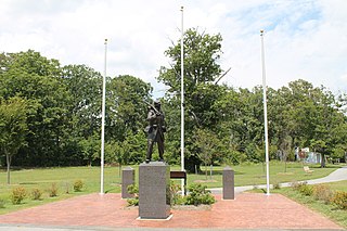
The United States Colored Troops Memorial Statue is a memorial to the more than 700 African-American soldiers and sailors from St. Mary's County, Maryland who served in the Union forces during the American Civil War.
