Owings Mills is an unincorporated community and census-designated place in Baltimore County, Maryland, United States. It is a suburb of Baltimore. Per the 2020 census, the population was 35,674. Owings Mills is home to the northern terminus of the Baltimore Metro Subway, and housed the Owings Mills Mall until its closure in 2015. It is also home to the Baltimore Ravens' headquarters facility, and the studios for Maryland Public Television. In 2008, CNNMoney.com named Owings Mills number 49 of the "100 Best Places to Live and Launch".

Ellicott City is an unincorporated community and census-designated place in, and the county seat of, Howard County, Maryland, United States. Part of the Baltimore metropolitan area, its population was 75,947 at the 2020 census, making it the most populous unincorporated county seat in the country.

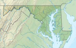
The Washington–Baltimore combined metropolitan statistical area is a statistical area including the overlapping metropolitan areas of Washington, D.C. and Baltimore. The region includes Central Maryland, Northern Virginia, three counties in the Eastern Panhandle of West Virginia, and one county in south-central Pennsylvania. It is the most educated, highest-income, and third-largest combined statistical area in the United States behind New York City–Newark, NJ and Los Angeles–Long Beach.

Hanover is an unincorporated community in the Baltimore/Annapolis area in northwestern Anne Arundel County and eastern Howard County in the U.S. state of Maryland, located south of Baltimore.

Mount Washington is an area of northwest Baltimore, Maryland. It is a designated city historic district and divided into two sections: South Road/Sulgrave to the southeast and Dixon's Hill to the north. The Mount Washington Historic District was listed on the National Register of Historic Places in 1990 with a boundary increase in 2001, with five contributing buildings and four contributing structures.
Cardiff is an unincorporated community in Harford County, Maryland, United States. The zip code for the area is 21160. The community name is taken from the Capital city of Wales.

Maryland Route 140 is a 49-mile (79 km) state highway in the U.S. state of Maryland. The route runs from U.S. Route 1 and US 40 Truck in Baltimore northwest to the Pennsylvania border, where the road continues into that state as Pennsylvania Route 16. MD 140 passes through the northern part of central Maryland, connecting Baltimore, Pikesville, Reisterstown, Westminster, Taneytown, and Emmitsburg.
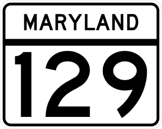
Maryland Route 129 is a state highway in the U.S. state of Maryland, running north-northwesterly from U.S. Route 40 and MD 295 in the city of Baltimore into Baltimore County, ending at Garrison Forest Road east of Reisterstown. The route leaves downtown on the one-way pair of McCulloh Street and Druid Hill Avenue, and then uses the entire length of Park Heights Avenue to the end. MD 129 connects Downtown Baltimore with Druid Hill Park using McCulloh Street and Druid Hill Avenue. As Park Heights Avenue, the state highway is one of two primary radial routes in the northwestern part of the city, providing access to The Maryland Zoo and Pimlico Race Course. In Baltimore County, MD 129 passes through Pikesville, where it has a junction with Interstate 695 (I-695) and serves an affluent rural area north of Pikesville and east of Reisterstown.
Milford Mill Road, Slade Avenue, and Smith Avenue are a long road mostly in Baltimore County, Maryland that runs through Milford Mill and Pikesville in the suburbs of Baltimore. The road starts out at the light rail stop in historic Mt. Washington Village in Baltimore city as Smith Avenue, and continues through Pikesville up to Seven Mile Lane before its name changes to Slade Avenue, and the road widens to four lanes. The road is known as Slade Avenue until Reisterstown Road, and from there, its name becomes Milford Mill Road until it dead-ends one block south of Rolling Road in an area known as Windsor Mill. It is one of the most heavily used routes in the northwest suburbs of Baltimore, as it is used for cross-county travel by motorists between the Pikesville and Randallstown areas.
Greenspring Avenue is a road in Baltimore, Maryland and its northwestern suburbs. At one time, Greenspring Avenue was Maryland Route 519 from Worthington Road to Dover Road, but the road has since been decommissioned and no longer has any numerical designation.
Fallstaff is a neighborhood in the Upper Park Heights area of Northwest Baltimore, Maryland, and is one of the city's northwesternmost communities. The area, which is mostly middle class, is part of the center of Baltimore's Orthodox Jewish community, and also has a heavy African-American and immigrant population.

Lake Roland is a 100-acre (0.40 km2) defunct reservoir in Baltimore County, Maryland. It was named for Roland Run, a nearby stream that feeds the lake and eventually flows into Jones Falls. It runs southeast through the city center to the Northwest Branch of the Patapsco River and the Baltimore Harbor. It is located just north of the Baltimore city limits.

Route 58 is a bus route operated by the Maryland Transit Administration in Baltimore and its suburbs. The line's western terminus is the Reisterstown Plaza Metro Subway Station, and its eastern terminus is White Marsh Mall, though some peak hour trips make short turns in Overlea. Route 58 serves the communities of Glen, Cheswolde, Fallstaff, a large section of Northern Parkway, and a portion of Belair Road in Baltimore County.

Route 34 is a bus route operated by the Maryland Transit Administration in Baltimore and its suburbs. The line currently operates weekdays only from the Reisterstown Plaza Metro Subway Station to Stevenson University during peak hours and Greenspring Station midday.

Sinai Hospital is an American private hospital based in Baltimore, Maryland, that was founded in 1866 as the Hebrew Hospital and Asylum. It is now a Jewish-sponsored teaching hospital that provides care for patients in the greater Baltimore City, Baltimore County and surrounding communities. The implantable cardioverter-defibrillator (ICD) was invented here by the team of Dr. Michel Mirowski, Dr. Morton Mower, M. Stephen Heilman, and Alois Langer who are all in the National Inventors Hall of Fame for their achievement.

Glyndon is an unincorporated community in Baltimore County, Maryland, United States. Founded in 1871 by Dr. Charles A. Leas, the village is located in the northwest section of Baltimore County and is primarily a residential suburb of metropolitan Baltimore City. Glyndon is listed on the National Register of Historic Places (1973) and on the Maryland Inventory of Historic Properties (1973); the Glyndon Historic District was also designated as the first historic district in Baltimore County (1981).

Remington is a neighborhood in northern Baltimore bordered to the north by Hampden, Wyman Park, and Johns Hopkins University and to the east by Charles Village. The southernmost boundary is North Avenue and the long southwestern boundary is formed by Falls Road in the I-83 corridor. The neighborhood is split between two Baltimore City Council Districts.
Hanlon Longwood is a neighborhood in the Northwest District of Baltimore, located between the neighborhoods of Garwyn Oaks (west) and Burleigh–Leighton (east). It is bounded by North Dukeland Street (east), Garrison Boulevard (west) and the Gwynns Falls Parkway (south). The neighborhood's north boundary is marked by North Longwood Street, North Hilton Street and Liberty Heights Avenue.

The Woodstock Quartz Monzonite is a Silurian or Ordovician quartz monzonite pluton in Baltimore County, Maryland. It is described as a massive biotite-quartz monzonite which intrudes through the Baltimore Gneiss at a single locality surrounding the town of Granite, Maryland.

The Cockeysville Marble is a Precambrian, Cambrian, or Ordovician marble formation in Baltimore, Carroll, Harford and Howard Counties, Maryland. It is described as a predominantly metadolomite, calc-schist, and calcite marble, with calc-gneiss and calc-silicate marble being widespread but minor.