King George County is a county located in the Commonwealth of Virginia. As of the 2010 census, the population was 23,584. Its county seat is King George.

La Plata is a town in Charles County, Maryland, United States. The population was 8,753 at the 2010 census. It is the county seat of Charles County.

Port Tobacco, officially Port Tobacco Village, is a town in Charles County, in southern Maryland, United States. The population was 13 at the 2010 census, making Port Tobacco the smallest incorporated town in Maryland.

Princess Anne is a town in Somerset County, Maryland, United States, and also serves as its county seat. The population was 3,290 at the 2010 census.

Leonardtown is a town in and the county seat of St. Mary's County, Maryland, United States. The population was 2,930 at the 2010 census. Leonardtown is perhaps most famous for the national oyster-shucking championship that occurs annually at the St. Mary's County fairgrounds.
Port Royal is an incorporated town in Caroline County, Virginia, United States. The population was 126 at the 2010 census.

The Province of Maryland was an English and later British colony in North America that existed from 1632 until 1776, when it joined the other twelve of the Thirteen Colonies in rebellion against Great Britain and became the U.S. state of Maryland. Its first settlement and capital was St. Mary's City, in the southern end of St. Mary's County, which is a peninsula in the Chesapeake Bay and is also bordered by four tidal rivers.
The Wicomico River is a 13.0-mile-long (20.9 km) tributary of the lower tidal portion of the Potomac River located in the U.S. state of Maryland south of Washington, DC. The river empties into the Potomac at Cobb Island and St. Margaret's Island. Its watershed area is 77 square miles (200 km2), with 2% impervious surface in 1994. in Charles, St. Mary's, and southern Prince George's counties. The lower section of the river forms part of the boundary between Charles and St. Mary's counties. The Wicomico River was designated a Scenic River under the Maryland Scenic River Act in 1968, and there are Scenic River Commissions for it in both Charles and St. Mary's counties.

Quantico Creek is a 13.7-mile-long (22.0 km) partially tidal tributary of the Potomac River in eastern Prince William County, Virginia. Quantico Creek rises southeast of Independent Hill, flows through Prince William Forest Park and Dumfries and empties into the Potomac at Possum Point.
The South River is a 10-mile-long (16 km) tributary of the Chesapeake Bay in Anne Arundel County, Maryland in the United States. It lies south of the Severn River, east of the Patuxent River, and north of the West River and Rhode River, and drains to the Chesapeake Bay.
Nanjemoy Creek is a 13.1-mile-long (21.1 km) tidal tributary of the Potomac River in Charles County, Maryland, United States, located between Cedar Point Neck and Tayloe Neck. Its watershed area is 73 square miles (190 km2), with 2% impervious surface in 1994.
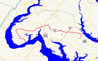
Maryland Route 6 is a state highway in the U.S. state of Maryland. The state highway runs 47.36 miles (76.22 km) from a dead end at the Potomac River in Riverside east to MD 235 in Oraville. MD 6 connects several small communities in southern Charles County and northern St. Mary's County with U.S. Route 301 in La Plata, the county seat of Charles County, and MD 5 in Charlotte Hall. The state highway also provides access to multiple historic sites around Port Tobacco, the original county seat of Charles County. MD 6 was one of the original highways numbered by the Maryland State Roads Commission in 1927. The state highway was constructed from La Plata to Riverside in the late 1910s and early 1920s. The La Plata–Charlotte Hall section of the highway was built in the mid-1920s. The portion of MD 6 east of Charlotte Hall was mostly built in the late 1920s and early 1930s. The final section of the state highway was completed in Oraville in 1940.
Fifteenmile Creek is a 19.9-mile-long (32.0 km) tributary stream of the Potomac River in the U.S. states of Maryland and Pennsylvania. The creek enters the Potomac River through Maryland's Green Ridge State Forest.
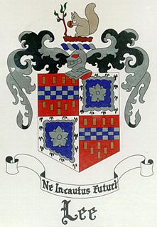
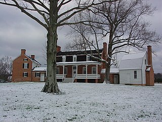
"Blenheim" was the once historic estate of the Lee family of Charles County, Maryland. It was owned by Capt. Philip Lee, Sr., Hon., Esq. (1681–1744).
Popes Creek is a 3.4-mile-long (5.5 km) stream in Charles County, Maryland and a tributary of the Potomac River.
Rock Run is a tributary stream of the Potomac River in Montgomery County, Maryland. The headwaters of the stream rise in the village of Potomac, and the creek flows southeast for 5.3 miles (8.5 km) to the Potomac River.

Plummers Island is a 12-acre Potomac River island in Montgomery County, Maryland, about nine miles upriver from Washington, D.C., which holds the distinction of being the most scientifically studied island in North America. It is visible from the American Legion Memorial Bridge of the Capital Beltway, just downriver (east) of the bridge.
Glymont is an unincorporated community in Charles County, Maryland, United States.
Taylorsville is an unincorporated place in Carroll County, Maryland, United States. Taylorsville is located where MD 26 and MD 27 intersect, approximately 17 miles east of Frederick and 27 miles northwest of Baltimore. Taylorsville is near Morgan Run Natural Environment Area.