
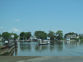
Claiborne is an unincorporated community in Talbot County, Maryland, United States. The village is located on the eastern shore of the Chesapeake Bay near the mouth of the Eastern Bay at 38°50′15″N76°16′40″W, and uses ZIP code 21624. The 2000 U.S. Census listed the population as 147 and the number of homes as 84, slightly down from its 1941 population of 156. Between 1890 and 1952, the village was a busy port for passenger and then automobile ferry service across the Chesapeake Bay, with numerous stores and motels/resorts, including Maple Hall. A post office was added in 1893 and the Protestant Episcopal Church of Claiborne was built in 1898. In 1912, an elementary school and Methodist Church were added. Before 1912, students attended school in nearby McDaniel. The town's first school consisted of the kitchen of the local railroad pavilion, used as a classroom, where Miss Dolly Thompson taught. Teachers in later years included Grace Oldham, Alice Dawson, Edna Harrison, and Lida Smith. In 1913, the town became home to the Claiborne Fresh Air Association, Inc., which was formed for the purpose of providing 10 weeks of fresh air and summer vacation for children who had been exposed to tuberculosis.

The Pocomoke River stretches approximately 66 miles (106 km) from southern Delaware through southeastern Maryland in the United States. At its mouth, the river is essentially an arm of Chesapeake Bay, whereas the upper river flows through a series of relatively inaccessible wetlands called the Great Cypress Swamp, largely populated by Loblolly Pine, Red Maple and Bald Cypress. The river is the easternmost river that flows into Chesapeake Bay. "Pocomoke", though traditionally interpreted as "dark water" by local residents, is now agreed by scholars of the Algonquian languages to be derived from the words for "broken ground."
The Wicomico River is a 24.4-mile-long (39.3 km) tributary of the Chesapeake Bay on the eastern shore of Maryland. It drains an area of low marshlands and farming country in the middle Delmarva Peninsula.

The Eastern Shore of Maryland is a part of the U.S. state of Maryland that lies mostly on the east side of the Chesapeake Bay and consists of nine counties, seven of which have Chesapeake Bay coastlines. The region also contains Maryland's only coast along the Atlantic Ocean.

The Choptank River is a major tributary of the Chesapeake Bay and the largest river on the Delmarva Peninsula. Running for 71 miles (114 km), it rises in Kent County, Delaware, runs through Caroline County, Maryland and forms much of the border between Talbot County, Maryland on the north, and Caroline County and Dorchester County on the east and south. It is located north of the Nanticoke River and its mouth is located south of Eastern Bay. Cambridge, the county seat of Dorchester County, and Denton, the county seat of Caroline County, are located on its south shore.
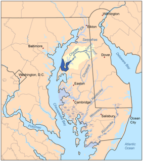
The Chester River is a major tributary of the Chesapeake Bay on the Delmarva Peninsula. It is about 43 miles (69 km) long, and its watershed encompasses 368 sq mi (950 km2), which includes 295 sq mi (760 km2) of land. Thus the total watershed area is 20% water. It forms the border between Kent County and Queen Anne's County, Maryland, with its headwaters extending into New Castle County and Kent County, Delaware. Chestertown, the seat of Maryland's Kent County, is located on its north shore. It is located south of the Sassafras River and north of Eastern Bay, and is connected with Eastern Bay through Kent Narrows.

Kent Island is the largest island in the Chesapeake Bay and a historic place in Maryland. To the east, a narrow channel known as the Kent Narrows barely separates the island from the Delmarva Peninsula, and on the other side, the island is separated from Sandy Point, an area near Annapolis, by roughly four miles (6.4 km) of water. At only four miles wide, the main waterway of the bay is at its narrowest at this point and is spanned here by the Chesapeake Bay Bridge. The Chester River runs to the north of the island and empties into the Chesapeake Bay at Kent Island's Love Point. To the south of the island lies Eastern Bay. The United States Census Bureau reports that the island has 31.62 square miles (81.90 km2) of land area.
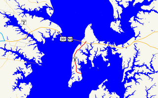
Maryland Route 8 is a state highway in the U.S. state of Maryland. Known for most of its length as Romancoke Road, the state highway runs 8.37 miles (13.47 km) from Romancoke Pier in Romancoke north to MD 18 in Stevensville. MD 8 is the main north–south highway of Kent Island in western Queen Anne's County. The state highway is also the first highway encountered on U.S. Route 50 and US 301 east of the Chesapeake Bay Bridge. South of Matapeake, MD 8 is paralleled by the Kent Island South Trail.
The Wye River is a 16.3-mile-long (26.2 km) tributary of the Chesapeake Bay, on the Eastern Shore of Maryland. It was named by the Lloyd family, Edward Lloyd (delegate), and Edward Lloyd, after the River Wye in the United Kingdom. It falls within Queen Anne's County and Talbot County, and joins the Miles River near its mouth to the Eastern Bay. The river is popular with recreational boaters because of its secluded anchorages, fishing, crabbing and proximity to the tourist attractions of St. Michaels, Maryland. Like many rivers on the Chesapeake Bay, the Wye is largely tidal. The river's features include the 2,800-acre (11 km2) Wye Island, most of which is part of the Wye Island Natural Resources Management Area, managed by the Maryland Department of Natural Resources State Forest and Park Service. William Paca, the third governor of Maryland and a signatory to the Declaration of Independence, once owned the island.
The Nanticoke River is a tributary of the Chesapeake Bay on the Delmarva Peninsula. It rises in southern Kent County, Delaware, flows through Sussex County, Delaware, and forms the boundary between Dorchester County, Maryland and Wicomico County, Maryland. The tidal river course proceeds southwest into the Tangier Sound, Chesapeake Bay. The river is 64.3 miles (103.5 km) long. A 26-mile ecotourism water trail running along the River was set aside in July 2011 by Delaware state and federal officials, contiguous with a 37-mile water-trail extending through Maryland to the Chesapeake Bay.
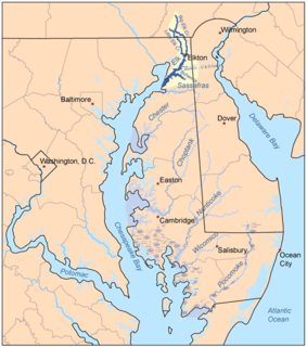
The Elk River is a tidal tributary of the Chesapeake Bay on the Eastern Shore of Maryland and on the northern edge of the Delmarva Peninsula. It is about 15 miles (24 km) long. As the most northeastern extension of the Chesapeake Bay estuary, it has served as one entrance to the Chesapeake & Delaware Canal since the 19th century. The canal and river now serve as one boundary of the Elk Neck Peninsula. The river flows through Cecil County, Maryland, with its watershed extending into New Castle County, Delaware and Chester County, Pennsylvania. Elkton, the county seat of Cecil County, is located at its head. Its total watershed area is 143 square miles (370 km2), with 21 square miles (54 km2) of open water, so its watershed is 15% open water. It is south and east of the North East River, and north of the Sassafras River.

Maryland Route 33 is a state highway in the U.S. state of Maryland. The state highway runs 23.17 mi (37.29 km) from Tilghman Island east to Washington Street in Easton. MD 33 connects Easton, the county seat of Talbot County, with all communities on the peninsula that juts west into the Chesapeake Bay between the Miles River and Eastern Bay on the north and the Tred Avon River and Choptank River on the south. The state highway passes through the historic town of Saint Michaels, home of the Chesapeake Bay Maritime Museum, and enters Tilghman Island by passing over Knapps Narrows on the busiest bascule drawbridge in the United States.
Middle Creek is a 17.1-mile-long (27.5 km) tributary of Toms Creek in Pennsylvania and Maryland in the United States.
The South River is a 10-mile-long (16 km) tributary of the Chesapeake Bay in Anne Arundel County, Maryland in the United States. It lies south of the Severn River, east of the Patuxent River, and north of the West River and Rhode River, and drains to the Chesapeake Bay.

The Northeast River is a tributary of the Chesapeake Bay in Maryland. Entirely tidal, it extends for about 5.0 miles (8.0 km) from the town of North East southwest past Charlestown to the main body of Chesapeake Bay between Carpenter's Point and Red Point. The river is fed by North East Creek and its tributaries, which reach as far north as just east of Nottingham, Pennsylvania. The Northeast River is entirely within Cecil County, Maryland, though its watershed extends into Chester County, Pennsylvania. Its watershed area in MD is 63 square miles (160 km2), with 6% impervious surface in 1994. On the 1612 John Smith map, it was referred to as Gunter's Harbour.
The Miles River is a 12.9-mile-long (20.8 km) tidal river in Talbot County, Maryland. It is a tributary of the Eastern Bay and is thus part of the Chesapeake Bay watershed.

Matapeake State Park is a public recreation area on Chesapeake Bay occupying the site of a former ferry landing in Matapeake, Kent Island, Maryland. The landing served the state-owned Chesapeake Bay Ferry System before the Chesapeake Bay Bridge opened. The park is leased and managed by Queen Anne's County.

The Tred Avon River is a main tributary of the Choptank River in Talbot County on Maryland's Eastern Shore. The river is 17 miles (27 km) long.

Bush River is a tidal estuary in Harford County, Maryland, located about 15 mi (24 km) northeast of Baltimore. The estuary extends from the community of Riverside, south for about 9 mi (14 km), to the Chesapeake Bay. The watershed area of tidal Bush River is 125 mi2 (320 km2), and includes Aberdeen Proving Ground, a military facility.
Town Creek is a tributary of the Tred Avon River in Talbot County on Maryland's Eastern Shore.


