
Milford Mill is an unincorporated community and census-designated place in Baltimore County, Maryland, United States. Per the 2020 census, the population was 30,622.
Lisbon is a census-designated place located in western Howard County in the state of Maryland, United States, located roughly between Baltimore and Frederick and north of Washington, D.C. It is contained in an area of roughly one square mile. Lisbon is located along Interstate 70 and Maryland Route 144 and is home to the first roundabout in Maryland. It first appeared as a CDP in the 2020 Census with a population of 282.

Greenbackville is a census-designated place (CDP) 4.5 miles (5 km) south of Stockton, Maryland in Accomack County, Virginia, located just south of the Maryland state line. Per the 2020 census, the population was 173.

Ketchuptown is a historic unincorporated community and census-designated place (CDP) located in Horry County, South Carolina, United States. Ketchuptown is at the intersection of Highways 23 and 99, about 9 miles (14 km) north of Aynor. As of the 2020 census, it had a population of 84.
Callaway is a census designated place in St. Mary's County, Maryland, United States. The elevation is 105 feet (32 m). Per the 2020 Census, the population was 1,779.
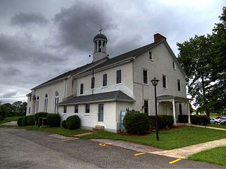
Graceham is an unincorporated community and a census-designated place (CDP) in Frederick County, Maryland, United States. Graceham is home to Graceham Moravian Church and Parsonage. Per the 2020 Census, the population was 243.

Lewistown is a census designated place and unincorporated community in Frederick County, Maryland, United States. Lewistown Elementary school, part of Frederick County Public Schools, is located in Lewistown. The town, founded in 1841, has had a school since the 19th century. There is a large elderly population in the community. It first appeared as a CDP in the 2020 Census with a population of 458.
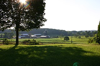
Crumpton is a census-designated place in Queen Anne's County, Maryland, United States. Crumpton is located along the Chester River, 5 miles (8.0 km) west-southwest of Millington. Crumpton has a post office with the ZIP code 21628.

Captains Cove is a census-designated place in Accomack County, Virginia. Per the 2020 census, the population was 1,544. Known as Captain's Cove Golf & Yacht Club, it is a recreational community located on the west shore of Chincoteague Bay, bordering Maryland to the north. While numerous families with children live here, it's largely a retirement community, with a median age of 51 and the largest age group being 60–64.
Butlertown is an unincorporated community and census-designated place in Kent County, Maryland, United States. Per the 2020 census, the population was 520.
Pattison, also known as Martin, is a census-designated place and unincorporated community in Claiborne County, Mississippi, United States. Its ZIP code is 39144.
Georgetown is an unincorporated community and census-designated place in western Kent County, Maryland, United States. Per the 2020 census, the population was 117. It should not be confused with the community of the same name 22 miles (35 km) to the northeast on the Kent/Cecil County border.
Ten Mile Creek is a census-designated place in Montgomery County, Maryland, United States. It was first listed as a CDP for the 2020 census, when it had a population of 1,012.
Flower Hill is a census-designated place in Montgomery County, Maryland, United States. It has a population of 14,108 as of its first recording in the 2020 census.
Navy is a census designated place in Fairfax County, Virginia, United States.
Honeygo is a census designated place in Baltimore County, Maryland, United States. It first appeared as a CDP in the 2020 Census with a population of 12,927.
Chesapeake Landing is a census designated place in Kent County, Maryland, United States. Per the 2020 Census, the population was 472.
Wildewood is a planned community and census-designated place (CDP) in St. Mary's County, Maryland, United States. It is in east-central St. Mary's County, 7 miles (11 km) east of Leonardtown, the county seat, and 58 miles (93 km) southeast of Washington, D.C. It is bordered to the east by the unincorporated community of California.
Brandywine Bay is a planned community and census-designated place (CDP) in Carteret County, North Carolina, United States. It was first listed as a CDP in the 2020 census with a population of 1,153.
Browntown is an unincorporated community and census-designated place (CDP) in Lee County, South Carolina, United States. It was first listed as a CDP prior to the 2020 census. The population as of 2020 was 206.


