Kingstown, Maryland

Last updated
Kingstown, Maryland
CDP
Queen Anne's County Maryland Incorporated and Unincorporated areas Kingstown Highlighted.svg
Coordinates: 39°12′32″N76°2′35″W / 39.20889°N 76.04306°W / 39.20889; -76.04306 Coordinates: 39°12′32″N76°2′35″W / 39.20889°N 76.04306°W / 39.20889; -76.04306
CountryUnited States
State Maryland
County Queen Anne's
Area
[1]
  Total2.58 sq mi (6.68 km2)
  Land2.27 sq mi (5.87 km2)
  Water0.31 sq mi (0.81 km2)
Elevation
16 ft (5 m)
Population
 (2020)
  Total1,689
  Density745.37/sq mi (287.84/km2)
Time zone UTC−5 (Eastern (EST))
  Summer (DST) UTC−4 (EDT)
FIPS code 24-44325
GNIS feature ID0597643

Kingstown is a census-designated place (CDP) in Queen Anne's County, Maryland, United States. The population was 1,644 at the 2000 census.

Contents

History

The log canoe Mystery was listed on the National Register of Historic Places in 1985. [2]

Geography

Kingstown is located at 39°12′32″N76°2′35″W / 39.20889°N 76.04306°W / 39.20889; -76.04306 (39.208840, 76.043034). [3]

According to the United States Census Bureau, the CDP has a total area of 2.6 square miles (6.7 km2), of which 2.2 square miles (5.7 km2) is land and 0.3 square miles (0.78 km2) (12.11%) is water.

Demographics

Historical population
CensusPop.Note
2020 1,689
U.S. Decennial Census [4]

As of the census [5] of 2000, there were 1,644 people, 668 households, and 486 families residing in the CDP. The population density was 733.2 inhabitants per square mile (283.1/km2). There were 719 housing units at an average density of 320.7 per square mile (123.8/km2). The racial makeup of the CDP was 92.82% White, 6.14% African American, 0.18% Native American, 0.49% Asian, 0.06% from other races, and 0.30% from two or more races. Hispanic or Latino of any race were 0.55% of the population.

There were 668 households, out of which 31.1% had children under the age of 18 living with them, 60.6% were married couples living together, 10.2% had a female householder with no husband present, and 27.2% were non-families. 22.9% of all households were made up of individuals, and 10.9% had someone living alone who was 65 years of age or older. The average household size was 2.46 and the average family size was 2.88.

In the CDP, the population was spread out, with 24.5% under the age of 18, 5.1% from 18 to 24, 24.9% from 25 to 44, 27.1% from 45 to 64, and 18.4% who were 65 years of age or older. The median age was 42 years. For every 100 females, there were 93.2 males. For every 100 females age 18 and over, there were 88.6 males.

The median income for a household in the CDP was $49,539, and the median income for a family was $59,063. Males had a median income of $40,820 versus $26,167 for females. The per capita income for the CDP was $26,616. About 1.3% of families and 4.2% of the population were below the poverty line, including 3.9% of those under age 18 and none of those age 65 or over.

Related Research Articles

<span class="mw-page-title-main">North Auburn, California</span> Census-designated place in California, United States

North Auburn is a census-designated place (CDP) in Placer County, California, United States. It is part of the Sacramento–Arden-Arcade–Roseville Metropolitan Statistical Area. The population was 13,452 at the 2020 census.

<span class="mw-page-title-main">Tahoe Vista, California</span> Census-designated place in California, United States

Tahoe Vista is a census-designated place located on the north shore of Lake Tahoe in Placer County, California. It is part of the Sacramento–Arden-Arcade–Roseville Metropolitan Statistical Area. The population was 1,433 at the 2010 census, down from 1,668 at the 2000 census.

<span class="mw-page-title-main">South Gate, Maryland</span> Former census-designated place in Maryland, United States

South Gate was a census-designated place (CDP) in Anne Arundel County, Maryland, United States, for the 2000 census, at which time its population was 28,672. It was added primarily to the Glen Burnie CDP for the 2010 census.

<span class="mw-page-title-main">Edgemere, Maryland</span> Census-designated place in Maryland, United States

Edgemere is an unincorporated community and census-designated place in Baltimore County, Maryland, United States. The population was 8,669 at the 2010 census. Founded in 1899 as Edgemere being renamed from previous name "Fitzell". Meeting held at the Fitzell Farm which was situated where the old Rheem plant was located.

<span class="mw-page-title-main">Rossville, Maryland</span> Census-designated place in Maryland, United States

Rossville is an unincorporated community and census-designated place in Baltimore County, Maryland, United States. The population was 15,147 at the 2010 census.

Clark Mills is a hamlet in Oneida County, New York, United States. The population was 1,905 at the 2010 census.

<span class="mw-page-title-main">North Sea, New York</span> Hamlet and census-designated place in New York, United States

North Sea is a hamlet and census-designated place (CDP) in the Town of Southampton in Suffolk County, on the South Fork of Long Island, in New York, United States. The population was 4,458 at the 2010 census.

<span class="mw-page-title-main">Turpin Hills, Ohio</span> Census-designated place in Ohio, United States

Turpin Hills is a census-designated place (CDP) outside of Anderson Township, Hamilton County, Ohio, United States. The population was 5,099 at the 2010 census.

<span class="mw-page-title-main">Choctaw Lake, Ohio</span> CDP in Ohio, United States

Choctaw Lake is a census-designated place (CDP) in Madison County, Ohio, United States. The population was 1,562 at the 2000 census.

<span class="mw-page-title-main">West Portsmouth, Ohio</span> Census-designated place in Ohio, United States

West Portsmouth is a census-designated place (CDP) in Scioto County, Ohio, United States. The population was 3,149 in accordance with the 2010 census. The citizens of West Portsmouth are served by the Washington-Nile Local School District.

<span class="mw-page-title-main">North Philipsburg, Pennsylvania</span> Census designated place in Pennsylvania, United States

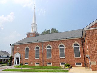
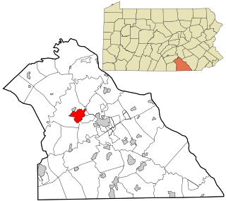
North Philipsburg is an unincorporated community and census-designated place (CDP) in Centre County, Pennsylvania, United States. It is part of the State College, Pennsylvania Metropolitan Statistical Area. The population was 660 at the 2010 census.

<span class="mw-page-title-main">Lightstreet, Pennsylvania</span> Census-designated place in Pennsylvania, United States

Lightstreet is a census-designated place (CDP) in Columbia County, Pennsylvania, United States. It is part of Northeastern Pennsylvania. The population was 1,093 at the 2010 census. It is part of the Bloomsburg-Berwick micropolitan area. The CDP is named after a street in Baltimore.

New Kingstown is a census-designated place (CDP) in Silver Spring Township, Cumberland County, Pennsylvania. The population was 495 at the 2010 census. It is part of the Harrisburg–Carlisle metropolitan statistical area.

Altamont is a census-designated place (CDP) in Schuylkill County, Pennsylvania, United States. The population was 2,689 at the 2000 census.

<span class="mw-page-title-main">Pennville, Pennsylvania</span> CDP in Pennsylvania, United States

Pennville is a census-designated place (CDP) in York County, Pennsylvania, United States. The population was 1,947 at the 2010 census.

<span class="mw-page-title-main">Spry, Pennsylvania</span> CDP in Pennsylvania, United States

Spry is a census-designated place (CDP) in York County, Pennsylvania, United States. The population was 4,891 at the 2010 census.

<span class="mw-page-title-main">Susquehanna Trails, Pennsylvania</span> CDP in Pennsylvania, United States

Susquehanna Trails is a census-designated place (CDP) in York County, Pennsylvania, United States. The population was 2,264 at the 2010 census.

<span class="mw-page-title-main">Weigelstown, Pennsylvania</span> CDP in Pennsylvania, United States

Weigelstown is a census-designated place (CDP) in York County, Pennsylvania, United States. The population was 12,875 at the 2010 census.

<span class="mw-page-title-main">Veradale, Washington</span> Locale in Washington, United States

Veradale—originally known as Vera—is a locale and former census-designated place (CDP) in Spokane County, Washington, United States. The population was 9,387 at the 2000 census. Veradale retains its own post office.

<span class="mw-page-title-main">Brewerton, New York</span> Census-designated place in New York, United States

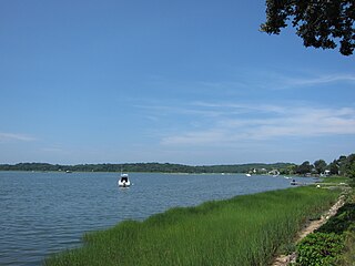
Brewerton is a census-designated place (CDP) in the town of Cicero in Onondaga County and the town of Hastings in Oswego County in the U.S. state of New York. It lies at the west end of Oneida Lake at its outlet into the Oneida River. The population was 4,029 at the 2010 census. Maps of the 19th century indicate that this area was once known as Fort Brewerton, while Brewerton meant the Cicero portion.

References

  1. "2020 U.S. Gazetteer Files". United States Census Bureau. Retrieved April 26, 2022.
  2. "National Register Information System". National Register of Historic Places . National Park Service. July 9, 2010.
  3. "US Gazetteer files: 2010, 2000, and 1990". United States Census Bureau. 2011-02-12. Retrieved 2011-04-23.
  4. "Census of Population and Housing". Census.gov. Retrieved June 4, 2016.
  5. "U.S. Census website". United States Census Bureau . Retrieved 2008-01-31.