Barclay, Maryland

Last updated

Barclay, Maryland
Flag of Barclay, Maryland.png
Seal of Barclay, Maryland.png
Queen Anne's County Maryland Incorporated and Unincorporated areas Barclay Highlighted.svg
Location of Barclay, Maryland
Coordinates: 39°8′41″N75°51′53″W / 39.14472°N 75.86472°W / 39.14472; -75.86472
Country Flag of the United States.svg  United States
State Flag of Maryland.svg  Maryland
County Queen Anne's
Incorporated 1931 [1]
Area
[2]
  Total0.40 sq mi (1.02 km2)
  Land0.40 sq mi (1.02 km2)
  Water0.00 sq mi (0.00 km2)
Elevation
69 ft (21 m)
Population
 (2020)
  Total183
  Density462.12/sq mi (178.57/km2)
Time zone UTC-5 (Eastern (EST))
  Summer (DST) UTC-4 (EDT)
ZIP code
21607
Area code 410
FIPS code 24-04250
GNIS feature ID0597048
Website Official Website

Barclay is a town in Queen Anne's County, Maryland, United States. The population was 120 at the 2010 census.

Contents

Geography

Barclay is located at 39°8′41″N75°51′53″W / 39.14472°N 75.86472°W / 39.14472; -75.86472 (39.144714, -75.864655). [3]

According to the United States Census Bureau, the town has a total area of 0.16 square miles (0.41 km2), all land. [4]

History

Barclay was founded in 1873 as Merrikton and renamed Barclay in 1890. The community was incorporated as the "Town of Barclay" in February 1931. [5]

MD 313 northbound in Barclay 2022-06-30 09 33 19 View north along Maryland State Route 313 (Goldsboro Road) at Maryland State Route 302 (Church Street) in Barclay, Queen Anne's County, Maryland.jpg
MD 313 northbound in Barclay

Transportation

The primary method of travel to and from Barclay is by road. Maryland Route 313 is the north-south road serving the town, while Maryland Route 302 is the east-west highway serving Barclay. Both connect to U.S. Route 301, which provides a high-speed route to nearby metropolitan areas such as Philadelphia and Washington D.C.

Demographics

Historical population
CensusPop.Note
1940 119
1950 108−9.2%
1960 14231.5%
1970 18731.7%
1980 132−29.4%
1990 17028.8%
2000 143−15.9%
2010 120−16.1%
2020 18352.5%
U.S. Decennial Census [6]

2010 census

As of the census [7] of 2010, there were 120 people, 48 households, and 32 families living in the town. The population density was 750.0 inhabitants per square mile (289.6/km2). There were 57 housing units at an average density of 356.3 per square mile (137.6/km2). The racial makeup of the town was 88.3% White, 0.8% African American, 4.2% Native American, and 6.7% from other races. Hispanic or Latino of any race were 9.2% of the population.

There were 48 households, of which 27.1% had children under the age of 18 living with them, 52.1% were married couples living together, 4.2% had a female householder with no husband present, 10.4% had a male householder with no wife present, and 33.3% were non-families. 29.2% of all households were made up of individuals, and 8.4% had someone living alone who was 65 years of age or older. The average household size was 2.50 and the average family size was 2.91.

The median age in the town was 42.5 years. 20% of residents were under the age of 18; 9.2% were between the ages of 18 and 24; 24.2% were from 25 to 44; 39.1% were from 45 to 64; and 7.5% were 65 years of age or older. The gender makeup of the town was 46.7% male and 53.3% female.

2000 census

As of the census [8] of 2000, there were 143 people, 54 households, and 42 families living in the town. The population density was 552.9 inhabitants per square mile (213.5/km2). There were 60 housing units at an average density of 232.0 per square mile (89.6/km2). The racial makeup of the town was 92.31% White, 6.99% African American, and 0.70% from two or more races.

There were 54 households, out of which 42.6% had children under the age of 18 living with them, 63.0% were married couples living together, 13.0% had a female householder with no husband present, and 22.2% were non-families. 20.4% of all households were made up of individuals, and 9.3% had someone living alone who was 65 years of age or older. The average household size was 2.65 and the average family size was 3.07.

In the town, the population was spread out, with 30.1% under the age of 18, 4.2% from 18 to 24, 30.8% from 25 to 44, 25.2% from 45 to 64, and 9.8% who were 65 years of age or older. The median age was 38 years. For every 100 females, there were 76.5 males. For every 100 females age 18 and over, there were 81.8 males.

The median income for a household in the town was $41,250, and the median income for a family was $46,250. Males had a median income of $36,250 versus $18,750 for females. The per capita income for the town was $19,698. There were none of the families and 2.5% of the population living below the poverty line, including no under eighteens and none of those over 64.

Notable residents

Politician William J. Winchester was born in Barclay circa 1876. He left Barclay for Wilmington, Delaware in 1888. [9]

Related Research Articles

<span class="mw-page-title-main">Masardis, Maine</span> Town in Maine, United States

Masardis is a town in Aroostook County, Maine, United States. The population was 204 at the 2020 census.

<span class="mw-page-title-main">Prospect, Maine</span> Town in the state of Maine, United States

Prospect is a town in Waldo County, Maine, United States. The population was 698 at the 2020 census.

<span class="mw-page-title-main">Whitneyville, Maine</span> Town in the state of Maine, United States

Whitneyville is a town in Washington County, Maine, United States. The town was named after Colonel Joseph Whitney, a mill owner. The population was 202 at the 2020 census.

<span class="mw-page-title-main">Marydel, Maryland</span> Town in Maryland

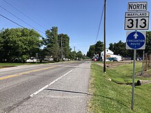
Marydel is an incorporated town in Caroline County, Maryland, United States. The population was 141 at the 2010 United States Census. Its name is a portmanteau, after its location, being partially located in Maryland and partially in Delaware. Marydel was originally known as Halltown.

<span class="mw-page-title-main">Union Bridge, Maryland</span> Town in Maryland, United States

Union Bridge is a town in Carroll County, Maryland, United States. The population was 936 at the 2020 census.

<span class="mw-page-title-main">Charlestown, Maryland</span> Town in Maryland, United States

Charlestown is a town in Cecil County, Maryland, United States. The population was 1,183 at the 2010 census.

<span class="mw-page-title-main">Friendsville, Maryland</span> Town in Maryland, United States

Friendsville is a town in Garrett County, Maryland, United States. The population was 438 at the 2020 census.

<span class="mw-page-title-main">Kitzmiller, Maryland</span> Town in Maryland, United States

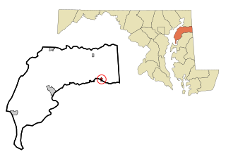
Kitzmiller is a town in Garrett County, Maryland, United States. The population was 321 at the 2010 census.

<span class="mw-page-title-main">Church Hill, Maryland</span> Town in Maryland, United States

Church Hill is a town in Queen Anne's County, Maryland, United States. The population was 745 at the 2010 census.

<span class="mw-page-title-main">Sudlersville, Maryland</span> Town in Maryland, United States

Sudlersville is a town in the far northeastern corner of Queen Anne's County, Maryland, United States. The ZIP code is 21668 and the area code is 410. The population was 497 at the 2010 census. It is perhaps best known as the hometown of Baseball Hall Of Fame slugger Jimmie Foxx. Other famous residents include astronomer and mathematician Simon Newcomb.

<span class="mw-page-title-main">Mardela Springs, Maryland</span> Town in Maryland, United States

Mardela Springs is a town in Wicomico County, Maryland, United States. The population was 357 at the 2010 census. It is included in the Salisbury, Maryland-Delaware Metropolitan Statistical Area.

<span class="mw-page-title-main">Pittsville, Maryland</span> Town in Maryland, United States

Pittsville is a town in Wicomico County, Maryland, United States. The population was 1,417 at the 2010 census. It is included in the Salisbury, Maryland-Delaware Metropolitan Statistical Area.

<span class="mw-page-title-main">Sharptown, Maryland</span> Town in Maryland, United States

Sharptown is a town in Wicomico County, Maryland, United States. The population was 651 at the 2010 census. It is included in the Salisbury, Maryland-Delaware Metropolitan Statistical Area.

<span class="mw-page-title-main">Saugerties South, New York</span> CDP in New York, United States

Saugerties South is a hamlet in Ulster County, New York, United States. The population was 2,442 at the 2020 census.

<span class="mw-page-title-main">Carpendale, West Virginia</span> Town in West Virginia, United States

Carpendale is a town in Mineral County, West Virginia, United States, and part of the Cumberland, MD-WV Metropolitan Statistical Area'. The population was 861 at the 2020 census. Carpendale was incorporated on January 2, 1990, by the Circuit Court. The town is a combination of three subdivisions of which its name reflects: Carpenters Addition, Millerdale I, and Millerdale II. There are no stores in Carpendale and there is only one road in and out of the town.

<span class="mw-page-title-main">Auburn, West Virginia</span> Town in West Virginia, United States

Auburn is a town in Ritchie County, West Virginia, United States. The population was 80 at the 2020 census.

<span class="mw-page-title-main">Pine Grove, West Virginia</span> Town in West Virginia, United States

Pine Grove is a town in Wetzel County, West Virginia, United States. The population was 363 at the 2020 census. The community was named for a grove of pine trees near the original town site.

<span class="mw-page-title-main">Templeville, Maryland</span> Town in Maryland, United States

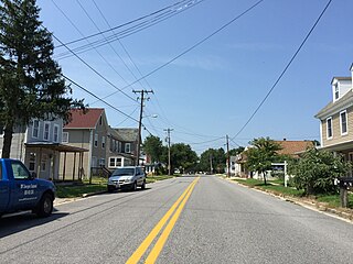
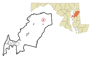
Templeville is a town in Caroline and Queen Anne's counties, Maryland, United States. Templeville is located near the Maryland-Delaware line. The population was 138 at the 2010 census. It was known as Bullock Town until the name was changed in 1847. The name Templeville derives from the Temple family, whose most famous member was Governor William Temple of Delaware.

<span class="mw-page-title-main">Millington, Maryland</span> Town in Maryland, United States

Millington is a town in Kent and Queen Anne's counties in the U.S. state of Maryland. The population was 642 at the 2010 census. Millington is the head of navigation for the Chester River.

<span class="mw-page-title-main">Black Earth (town), Wisconsin</span>

The Town of Black Earth is located in Dane County, Wisconsin, United States. The population was 510 at the 2020 census.

References

  1. "Barclay". Maryland Manual. Retrieved June 27, 2017.
  2. "2020 U.S. Gazetteer Files". United States Census Bureau. Retrieved April 26, 2022.
  3. "US Gazetteer files: 2010, 2000, and 1990". United States Census Bureau. February 12, 2011. Retrieved April 23, 2011.
  4. "US Gazetteer files 2010". United States Census Bureau. Archived from the original on January 12, 2012. Retrieved January 25, 2013.
  5. "Barclay Maryland Website: The Official Site Of The Town Of Barclay, MD". Welcome to Barclay Maryland. Retrieved January 8, 2018.
  6. "Census of Population and Housing". Census.gov. Retrieved June 4, 2015.
  7. "U.S. Census website". United States Census Bureau . Retrieved January 25, 2013.
  8. "U.S. Census website". United States Census Bureau . Retrieved January 31, 2008.
  9. "William J. Winchester Dies; First of Race in State Assembly". The News Journal. January 3, 1952. p. 1. Retrieved July 17, 2022.