Related Research Articles

Kenton is a town in Kent County, Delaware, United States. It is part of the Dover metropolitan statistical area. The population was 215 in 2020.

Wyoming is a town in Kent County, Delaware, United States. It was named after the Wyoming Valley in Pennsylvania. It is part of the Dover, Delaware, Metropolitan Statistical Area. The population was 1,680 in 2020.

Ellendale is a town in Sussex County, Delaware, United States. The population was 487 at the 2020 census, an increase of 27.8% since the 2010 census, and a 48.9% increase since the year 2000. It is part of the Salisbury, Maryland-Delaware Metropolitan Statistical Area. Ellendale is the "Gateway to Delaware's Resort Beaches" because it is the town located on U.S. Route 113, the resort area's westernmost border, and Delaware Route 16, the resort area's northernmost border with the eastern border being the Delaware Bay and Atlantic Ocean and the southern border being the state line with Maryland.

Arbutus is an unincorporated community and a census-designated place in Baltimore County, Maryland, United States. The population was 20,483 at the 2010 census. The census area also contains the communities of Halethorpe and Relay, in which all three names were used during the 1960 census when the area had a population of 22,402.

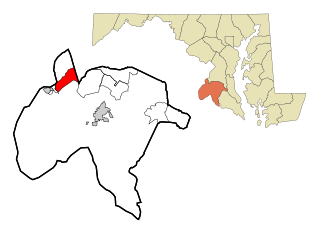
Chesapeake City is a town in Cecil County, Maryland, United States. The population was 736 at the 2020 census.
Bryans Road is a census-designated place (CDP) in Charles County, Maryland, United States. Per the 2020 census, the population was 8,650.

Laurel is a city in Maryland, United States, located midway between Washington, D.C. and Baltimore on the banks of the Patuxent River. While the city limits are entirely in northern Prince George's County, outlying developments extend into Anne Arundel, Montgomery and Howard counties. Founded as a mill town in the early 19th century, Laurel expanded local industry and was later able to become an early commuter town for Washington and Baltimore workers following the arrival of the Baltimore and Ohio Railroad in 1835. Largely residential today, the city maintains a historic district centered on its Main Street, highlighting its industrial past.
University Park is a town in Prince George's County, Maryland, United States. The population was 2,548 at the 2010 census.

Lexington Park is a census-designated place (CDP) in St. Mary's County, Maryland, United States, and the principal community of the Lexington Park, Maryland Micropolitan Statistical Area. The population was 11,626 at the 2010 census.

Williamsport is a town in Washington County, Maryland, United States. The population was 1,868 at the 2000 census and 2,137 as of 2010.

Todd Township is a township in Fulton County, Pennsylvania, United States. The population was 1,605 at the 2020 census.
New Hill is an unincorporated community located in southwestern Wake County, North Carolina, United States, at the crossroads of old U.S. 1, New Hill Olive Chapel Road and New Hill Holleman Road. New Hill is located along the original alignment of the New Hope Valley Railway between Durham and Bonsal. The ZIP Code for New Hill is 27562.

Dickerson is an unincorporated community in Montgomery County, Maryland. It is on Maryland Route 28, between Sugarloaf Mountain and the Potomac River. It is a community near the town of Poolesville, Maryland. Dickerson is 61.5 square miles (159 km2).

Fall Creek Township is one of fourteen townships in Madison County, Indiana, United States. As of the 2010 census, its population was 14,695 and it contained 4,570 housing units.

Tuckahoe State Park is a public recreation area located along Tuckahoe Creek in Caroline and Queen Anne's counties on the Eastern Shore of Maryland, United States. Adkins Arboretum, a garden and preserve maintaining over 600 native plant species, occupies 500 acres of the park. The arboretum provides classes to the public in horticulture, ecology and natural history.

Sassafras is an unincorporated community in Kent County, Maryland, United States. The Lanthim House, built in the 1720s, served as a general store.
Marion Station, also known as Marion, is an unincorporated community in Somerset County, Maryland, United States. It is located at the northern intersection of Maryland routes 413 and 667. After the arrival of the Pennsylvania Railroad arm known as the "Eastern Shore Railroad" toward Crisfield in 1866, Marion was locally hailed as the "strawberry capital of the world". After the trains stopped coming it went into decline, with some sources even hailing it as a ghost town.

Thornton is an unincorporated community spanning Thornbury Township, Concord Township and Middletown Township in Delaware County, Pennsylvania, United States.
Pen Mar is an unincorporated community in Washington County, Maryland, and Franklin County, Pennsylvania, United States. It is one of the border towns in the United States with a portmanteau name. Pen Mar came to prominence as a resort in the 20th century after the construction of Pen Mar Park by the Western Maryland Railway. While the resort has long been dismantled, the area still has some significance in Maryland, since it is the northern starting point for the Maryland section of the Appalachian Trail.
References
- ↑ U.S. Geological Survey Geographic Names Information System: Ruthsburg, Maryland
- ↑ "Some in Md. town call anti-terrorism training plan a dud," The Washington Post, by Aaron C. Davis, February 23, 2010
- ↑ "National Register Information System". National Register of Historic Places . National Park Service. July 9, 2010.
Municipalities and communities of Queen Anne's County, Maryland, United States | ||
|---|---|---|
| Towns |  | |
| CDPs | ||
| Other communities | ||
| Footnotes | ‡This populated place also has portions in an adjacent county or counties | |
39°00′11″N75°57′29″W / 39.00306°N 75.95806°W