
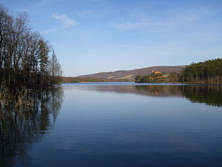
Deep Creek Lake State Park is a public recreation area occupying more than 1,100 acres (450 ha) on the northeast side of Deep Creek Lake in Garrett County, Maryland, in the United States. The park features water activities, camping facilities, and recreational trails and is located about 18 miles (29 km) south of Interstate 68 on U.S. Route 219.
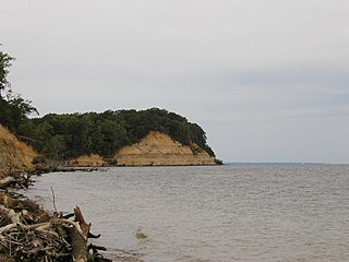
Calvert Cliffs State Park is a public recreation area in Lusby, Calvert County, Maryland, that protects a portion of the cliffs that extend for 24 miles along the eastern flank of the Calvert Peninsula on the west side of Chesapeake Bay from Chesapeake Beach southward to Drum Point. The state park is known for the abundance of mainly Middle Miocene sub-epoch fossils that can be found on the shoreline.
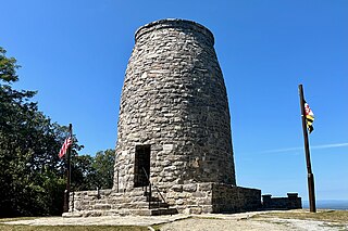
Washington Monument State Park is a public recreation area located approximately one mile (1.6 km) southeast of Boonsboro, Maryland. The park preserves the Washington Monument, a 40-foot-tall (12 m) tower honoring George Washington, the first President of the United States. The monument sits along the Appalachian Trail near the summit of South Mountain's Monument Knob. It was added to the National Register of Historic Places in 1972. The park is managed by the Maryland Department of Natural Resources.

Seneca Creek State Park is a public recreation area encompassing more than 6,300 acres (2,500 ha) along 14 miles of Seneca Creek in its run to the Potomac River in Montgomery County, Maryland. The park features facilities for boating and fishing as well as trails for hiking, cycling, and horseback riding. It is managed by the Maryland Department of Natural Resources.

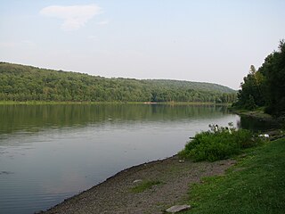
Tiadaghton State Forest is a Pennsylvania State Forest in the Pennsylvania Department of Conservation and Natural Resources, Bureau of Forestry. The forest is primarily in western and southern Lycoming County, with small portions in Clinton, Potter, Tioga, and Union Counties. The district's topography consists of narrow, flat to sloping plateaus cut by deep, steep-sloped valleys carved by fast moving mountain streams, including Pine Creek, Slate Run, and their tributaries. The Tiadaghton district extends south across the lowland along the west branch of the Susquehanna River to the narrow crests of Bald Eagle Mountain and North and South White Deer Ridge. The majority of forest cover is dominated by mixed oak forests, with some areas of northern hardwoods. The Tiadaghton State Forest is one of eight forest districts in the Pennsylvania Wilds region.
Rocky Gap State Park is a public recreation area with resort features located on Interstate 68, seven miles (11 km) east of Cumberland in Allegany County, Maryland. The state park's 3,000 acres (1,200 ha) include Lake Habeeb, Evitts Mountain, and the privately owned and operated Rocky Gap Casino Resort. The park offers water recreation, camping facilities, and hiking trails. The park is managed by the Maryland Department of Natural Resources, the resort by Golden Entertainment, Inc.

White Clay Creek Preserve is a 3,050-acre (1,230 ha) Pennsylvania state park along the valley of White Clay Creek in London Britain Township in Chester County, Pennsylvania in the United States. The park was donated by the DuPont Company in 1984 for the purpose of "preserving the diverse and unique plant and animal species, and the rich cultural heritage of the area". Dupont also donated an additional 528 acres (214 ha) for the adjoining White Clay Creek State Park to the state of Delaware. White Clay Creek Preserve is 3 miles (4.8 km) north of Newark, Delaware on Pennsylvania Route 896.
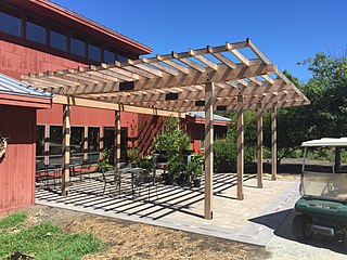
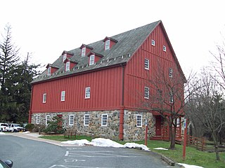
Adkins Arboretum is a 400-acre native garden and arboretum located within Tuckahoe State Park at 12610 Eveland Road, Ridgely, Maryland. The grounds contain five miles of paths through meadows and native plant gardens on the Eastern Shore of Maryland. Its gardens contain a "living collection" of more than 600 species of native shrubs, trees, wildflowers and grasses, used to promote land stewardship practices in the Chesapeake Bay region.

Samuel S. Lewis State Park is an 85-acre (34 ha) Pennsylvania state park in Lower Windsor Township, York County, Pennsylvania, in the United States. Mt. Pisgah is an 885-foot-high (270 m) ridge that is the focus of recreation for the park. The ridge separates East Prospect Valley from Kreutz Creek Valley. An overlook on Mt. Pisgah gives visitors of view of the Susquehanna River Valley. Samuel S. Lewis Park is twelve miles (19 km) east of York near U.S. Highway 30.
Prompton State Park is a Pennsylvania state park on 2,000 acres (809 ha) in Clinton and Dyberry Townships, Wayne County, Pennsylvania in the United States. This park, which was established in 1962, is officially listed by the Pennsylvania Department of Conservation and Natural Resources as being undeveloped. This means that it is officially a state park but the PA-DCNR is not currently managing the park. However, the lands of the park are open to visitors. Friends of Prompton State Park, a grassroots organization is working to take over management of the park in much the same way that Salt Springs State Park in Susquehanna County is managed by The Friends of Salt Springs Park. Northeast Sports Ltd. of Honesdale sponsors several outdoor sports events that are held at the park. Prompton State Park is 4.2 miles (6.8 km) west of Honesdale on Pennsylvania Route 170.
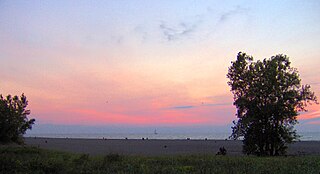
Headlands Beach State Park is a public beach in Mentor and Painesville Township, Ohio, United States. It is the longest natural beach in Ohio and attracts two million visitors annually. The breakwall at the eastern end of the park, frequented by fishermen, is surmounted by the Fairport Harbor West Breakwater Light. The park features a 35-acre beach for sunbathing, swimming, and beach glass hunting along with picnicking facilities and seasonal concessionaire.

Dinosaur State Park and Arboretum is a state-owned natural history preserve occupying 80 acres (32 ha) in the town of Rocky Hill, Connecticut. The state park protects one of the largest dinosaur track sites in North America. The park was created in recognition of fossil trackways embedded in sandstone from the beginning of the Jurassic period, about 200 million years ago. The facility is managed by the Connecticut Department of Energy and Environmental Protection.

Patapsco Valley State Park is a Maryland state park extending along 32 miles (51 km) of the Patapsco River south and west of the city of Baltimore, Maryland. The park encompasses multiple developed areas on over 14,000 acres (5,700 ha) acres of land, making it Maryland's largest state park. In 2006, it was officially celebrated as Maryland's first state park, its first formation being in 1906. Patapsco Valley State Park is managed by the Maryland Department of Natural Resources.

Matapeake State Park is a public recreation area on Chesapeake Bay occupying the site of a former ferry landing in Matapeake, Kent Island, Maryland. The landing served the state-owned Chesapeake Bay Ferry System before the Chesapeake Bay Bridge opened. The park is leased and managed by Queen Anne's County.
Gunpowder Falls State Park is a public recreation area comprising six non-contiguous areas covering 18,000 acres (7,300 ha) in northeastern Baltimore County and western Harford County, Maryland. The state park is primarily made up of the stream valleys of the Big and Little Gunpowder Falls and the Gunpowder River; its natural features range from tidal marshes to rugged interior slopes. The park has over 120 miles of trails for hiking, biking, horseback riding, and cross-country skiing plus facilities for picnicking, tubing, canoeing and kayaking, tide-water fishing and crabbing, fly fishing, and hunting, among other activities. It is managed by the Maryland Department of Natural Resources.

Tuckahoe Creek is a 21.5-mile-long (34.6 km) tributary of the Choptank River on Maryland's Eastern Shore. It is sometimes (erroneously) referred to as the Tuckahoe River. Upstream of Hillsboro, it forms the boundary between Caroline County and Queen Anne's County, passing through Tuckahoe State Park and dividing the small towns of Queen Anne and Hillsboro. Downstream of Hillsboro, it forms the boundary between Caroline County and Talbot County, before flowing into the Choptank.

Hart-Miller Island State Park is a state-owned, public recreation area located on Hart-Miller Island, a man-made landfill linking two natural Chesapeake Bay islands Hart and Miller at the mouth of Back River in Essex, Maryland. The state park is accessible only by boat. It is located in Essex, Maryland, 21221.

Rosaryville State Park is a public recreation area with historical features located three miles southeast of Joint Base Andrews in Rosaryville, Prince George's County, Maryland. The state park includes the restored Mount Airy Mansion, which was formerly operated as an event facility, as well as hiking, biking and equestrian trails for day-use.

Smallwood State Park is a public recreation and historic preservation area located on Mattawoman Creek near Marbury, Charles County, Maryland. The state park preserves Smallwood's Retreat, the plantation home of former Continental Army officer and Governor of Maryland, Major General William Smallwood. The park's 984 acres (398 ha) include a marina, boat ramps, picnicking facilities, campsites, cabins, trails, and nature center.

Matthew Henson State Park is a publicly owned greenway with recreational features that runs along Turkey Branch, a tributary of Rock Creek, in Montgomery County, Maryland. The state park is managed by Montgomery County under an agreement with the Maryland Department of Natural Resources. It was named for Maryland native and arctic explorer Matthew Henson.

