Montgomery County is the most populous county in the U.S. state of Maryland. As of the 2020 census, the county's population was 1,062,061, increasing by 9.3% from 2010. The county seat and largest municipality is Rockville, although the census-designated place of Germantown is the most populous place within the county. Montgomery County, which adjoins Washington, D.C., is part of the Washington–Arlington–Alexandria, DC–VA–MD–WV metropolitan statistical area, which in turn forms part of the Baltimore–Washington combined statistical area. Most of the county's residents live in unincorporated locales, of which the most urban are Silver Spring and Bethesda, although the incorporated cities of Rockville and Gaithersburg are also large population centers, as are many smaller but significant places.
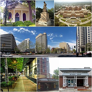
Bethesda is an unincorporated, census-designated place in southern Montgomery County, Maryland, United States. It is located just northwest of Washington, D.C. It takes its name from a local church, the Bethesda Meeting House, which in turn took its name from Jerusalem's Pool of Bethesda. The National Institutes of Health's main campus and the Walter Reed National Military Medical Center are in Bethesda, in addition to a number of corporate and government headquarters.

Silver Spring is a census-designated place (CDP) in southeastern Montgomery County, Maryland, United States, near Washington, D.C. Although officially unincorporated, it is an edge city with a population of 81,015 at the 2020 census, making it the fifth-most populous place in Maryland after Baltimore, Columbia, Germantown, and Waldorf.

Takoma Park is a city in Montgomery County, Maryland, United States. It is a suburb of Washington, and part of the Washington metropolitan area. Founded in 1883 and incorporated in 1890, Takoma Park, informally called "Azalea City", is a Tree City USA and a nuclear-free zone. A planned commuter suburb, it is situated along the Metropolitan Branch of the historic Baltimore and Ohio Railroad, just northeast of Washington, D.C., and it shares a border and history with the adjacent Washington, D.C. neighborhood of Takoma. It is governed by an elected mayor and six elected councilmembers, who form the city council, and an appointed city manager, under a council-manager style of government. The city's population was 17,629 at the 2020 census.

Montgomery Blair High School (MBHS) is a public high school in Four Corners, Maryland, United States, operated by Montgomery County Public Schools. Its enrollment of 3,600 makes it the largest school in Montgomery County and in the state.
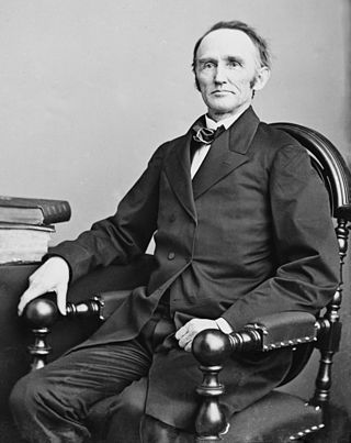
Montgomery Blair was an American politician and lawyer from Maryland. He served in the Lincoln administration cabinet as Postmaster-General from 1861 to 1864, during the Civil War. He was the son of Francis Preston Blair, elder brother of Francis Preston Blair Jr. and cousin of B. Gratz Brown.

Francis Preston Blair Sr. was an American journalist, newspaper editor, and influential figure in national politics advising several U.S. presidents across party lines.

Interstate 270 (I-270) is a 34.7-mile (55.8 km) auxiliary Interstate Highway in the U.S. state of Maryland that travels from I-495 just north of Bethesda in Montgomery County north to I-70 in the city of Frederick in Frederick County. It consists of the 32.6-mile (52.5 km) mainline as well as a 2.1-mile (3.4 km) spur that provides access to and from southbound I-495. I-270 is known as the Washington National Pike, and makes up the easternmost stretch of the Dwight D. Eisenhower Highway. Most of the southern part of the route in Montgomery County passes through suburban areas around Rockville and Gaithersburg that are home to many biotech firms. This portion of I-270 is up to 12 lanes wide and consists of a local–express lane configuration as well as high-occupancy vehicle lanes that are in operation during peak travel times. North of the Gaithersburg area, the road continues through the northern part of Montgomery County, passing Germantown and Clarksburg as a six- to eight-lane highway with an HOV lane in the northbound direction only. North of here, I-270 continues through rural areas into Frederick County and toward the city of Frederick as a four-lane freeway.
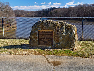
Lake Bernard Frank, is a 54-acre (220,000 m2) reservoir on the North Branch of Rock Creek in Derwood, Maryland, U.S., just east of Rockville. In the late 1960s it was renamed after Bernard Frank, a wilderness activist and a co-founder of The Wilderness Society. The lake's boundaries are, approximately, Route 28, East Gude Drive, Avery Road, and Muncaster Mill Road. Lake Frank was created in 1966 as Lake Norbeck to aid in flood and sediment control, as well as to provide recreation. It has an earthen dam, installed in 1967, on its southern side. It was created as a sister lake to Lake Needwood. Lake Frank is owned by the Maryland-National Capital Park and Planning Commission (M–NCPPC).
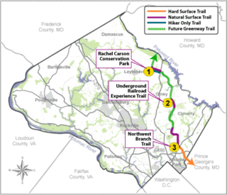
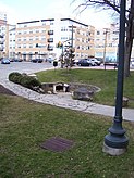
The Rachel Carson Greenway is a planned 25-mile stretch of trails, spanning from the historic Adelphi Mill in Prince George's County north through eastern Montgomery County, Maryland to Patuxent River State Park, and incorporating existing Northwest Branch trails. The greenway was proposed as part of a 1998 Countywide Park Trails Plan. A plan for the greenway was approved by the Montgomery County Planning Board on June 15, 2005.

Maryland Route 390 is a state highway in the U.S. state of Maryland. The highway runs 1.09 miles (1.75 km) from 16th Street at the District of Columbia boundary north to MD 97 within Silver Spring. MD 390 is a six-lane divided highway continuation of 16th Street into Maryland and serves as a western bypass of downtown Silver Spring. The portion of the highway south of MD 410 was constructed around 1930. MD 390 was extended north to MD 97 as a divided highway in the late 1950s.

Elizabeth Blair Lee was an American woman who lived through the American Civil War and wrote hundreds of letters describing the events of the times to her husband, Samuel Phillips Lee. She played a pivotal role in several Washington, D.C. charities, particularly the Washington City Orphan Asylum where she was a manager and directress for decades.
The Metropolitan Branch Trail is an American rail trail between the transit center in Silver Spring, Maryland, and Union Station in the District of Columbia. Part of the East Coast Greenway, it extends the Capital Crescent Trail where it merges with the active WMATA and CSX railroad tracks into the national capital. Planned connections include a trail from Fort Totten to the Northwest Branch Trail of the Anacostia Tributary Trail System at Hyattsville, Maryland; and an on-street connection from Union Station to the National Mall.

Northwest Branch Anacostia River is a 21.5-mile-long (34.6 km) free-flowing stream in Montgomery County and Prince George's County, Maryland. It is a tributary of the Anacostia River, which flows to the Potomac River and the Chesapeake Bay.

Four Corners is a neighborhood and census-designated place (CDP) in Montgomery County, Maryland, United States. Many residents consider the neighborhood a part of Silver Spring, to whose CDP it belonged until 2010. It had a population of 8,316 at the 2020 census.

Wheaton Regional Park is a public park and county-designated protected area, located in Wheaton, Maryland. It is operated and managed by Montgomery County Parks, a division of a bi-county agency, Maryland-National Capital Park and Planning Commission (M–NCPPC), which serves both Montgomery and Prince George's counties in the Washington, D.C. suburbs of the state of Maryland. The park was established in 1960, incorporating several large parcels of land into one of the county's largest parks, at the size of 538.7 acres.

The Brigadier General Charles E. McGee Library, formerly the Silver Spring Library, is part of the Montgomery County Public Libraries System. It opened to the public in 1931 and is currently located at 900 Wayne Avenue in Silver Spring, Maryland. The library is named for Charles E. McGee, a Tuskegee Airman who had lived in Montgomery County.

Maryland Route 594 is an unsigned state highway in the U.S. state of Maryland. Known as Wayne Avenue, the highway runs 1.40 miles (2.25 km) from U.S. Route 29 east to Flower Avenue within Silver Spring in southeastern Montgomery County. This segment is part of a collection of four auxiliary routes designated as MD 594 in the Silver Spring area. Wayne Avenue is designated MD 594A, while the three other auxiliary routes are designated MD 594B, MD 594C, and MD 594D. MD 594A, MD 594B, MD 594C, and MD 594D were transferred to the state from Montgomery County in 2016. MD 594E and MD 594F, which were located in Prince George's County, were transferred to the state from the county in 2017. In 2019, MD 594E and MD 594F were renumbered to MD 431 and MD 433 respectively.
Lyttonsville is a mostly residential neighborhood of Silver Spring, Maryland. Established in the 1850s, it is among the oldest neighborhoods in Montgomery County and is a notable example of a community created by free African Americans before the Civil War. Today, Lyttonsville is a 68-acre, predominantly residential neighborhood mostly composed of modest single-family homes.

Forest Glen Park is an unincorporated community in Montgomery County, Maryland, United States, and a residential neighborhood within the Silver Spring census-designated place. The community is adjacent to Rock Creek, Rock Creek Regional Park, and to the United States Army's Forest Glen Annex.