
College Park–University of Maryland station is a Washington Metro station in Prince George's County, Maryland, on the Green Line. It also serves MARC's Camden Line, though only select trains stop at the station.

Sligo Creek Trail is a paved hiker-biker trail running along Sligo Creek in the suburbs of Washington, D.C. Most of the trail passes through tree-filled parkland. The trail and surrounding park is a popular place for locals to jog, walk, bicycle, roller-skate, and take their children to the playground. Many local families enjoy picnicking at one of the 15 picnic areas along the trail.
Watts Branch is a tributary stream of the Potomac River in Montgomery County, Maryland.

Maryland Route 488 is a state highway in the U.S. state of Maryland. Known as La Plata Road, the state highway runs 6.01 miles (9.67 km) from MD 6 in La Plata east to MD 5 near Bryantown. MD 488 is a connector between La Plata and eastern Charles County, including the town of Hughesville. The state highway was constructed in the mid-1930s.
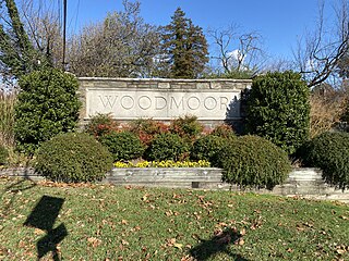
Woodmoor is a neighborhood in the northern section of Silver Spring, Maryland in southeastern Montgomery County, in the U.S. state of Maryland. Its borders extend from U.S. 29 to the west, Northwest Branch Park to the north, the Capital Beltway (I-95) to the east, and University Boulevard to the south. It lies on one of the "Four Corners" at the northeastern corner of the intersection of Colesville Road, and University Boulevard.

Maryland Route 320 is a state highway in the U.S. state of Maryland. Known as Piney Branch Road, the highway runs 2.84 miles (4.57 km) from Eastern Avenue at the District of Columbia boundary in Takoma Park north to MD 650 in Adelphi. MD 320 is a southwest–northeast highway that connects Takoma Park and Silver Spring in southeastern Montgomery County with Adelphi in far western Prince George's County. The state highway originally extended from downtown Silver Spring to White Oak and connected with U.S. Route 29 at both ends. The Silver Spring–Adelphi portion of the highway was constructed in 1910. The segment through Takoma Park and the Adelphi–White Oak segment, which later became MD 650, were built in the early 1930s; the Takoma Park portion was built as MD 513. MD 320 was widened over its whole length in the late 1940s and reduced to its present course in the mid-1950s.

Sligo Creek Parkway is a two-lane at-grade automobile parkway in Montgomery County in the U.S. state of Maryland. The two-lane parkway runs 5.6 mi (9.0 km) from Maryland Route 650 in Takoma Park through Silver Spring north to MD 193 in Maryland. Sligo Creek Parkway parallels Sligo Creek and the Sligo Creek Trail as it passes through various units of Sligo Creek Park and by a variety of recreational facilities. The parkway is maintained by the Maryland-National Capital Park and Planning Commission. Sligo Creek Parkway is closed to trucks at all times. In addition, the section between Old Carroll Avenue and MD 320 is closed to automobile traffic on Sundays.

Viva Purple is a line on the Viva bus rapid transit system in York Region, Ontario, Canada. The route primarily runs in an east–west direction along the Highway 7 Rapidway in Markham and Richmond Hill. It is operated by Tok Transit under contract from York Region.

Four Corners is a neighborhood and census-designated place (CDP) in Montgomery County, Maryland, United States. Many residents consider the neighborhood a part of Silver Spring, to whose CDP it belonged until 2010. It had a population of 8,316 at the 2020 census.
The Takoma Langley Crossroads Transit Center is a bus transit center in Langley Park, Maryland. It is at the intersection of University Boulevard and New Hampshire Avenue, and is the largest bus-only transfer in the Washington, D.C. metropolitan area. It is a future transfer point for the Purple Line.
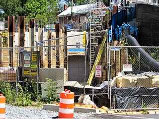
Manchester Place is a light rail station that is currently under construction. It will be part of the Purple Line in Maryland. The station will be located underground in between Wayne Avenue and Plymouth Street.

Long Branch is a light rail station that is currently under construction in the Long Branch neighborhood of Silver Spring, Maryland. It will be part of the Purple Line in Maryland. The station will be located at Arliss Street and Piney Branch Road, adjacent to the Long Branch Library.
Riggs Road is a light rail station that is currently under construction. It will be part of the Purple Line in Maryland. The station will be located at the intersection of Riggs Road and University Boulevard.
Adelphi Road–UMGC–UMD is a light rail station that is currently under construction. It will be part of the Purple Line in Maryland. The station will be located on the west border of the University of Maryland at the intersection of Adelphi Road and Campus Drive.

Campus Drive–UMD is a light rail station that is currently under construction. It will be part of the Purple Line in Maryland. The station will be located at the intersection of Campus Drive and Library Lane on the campus of the University of Maryland.
Riverdale Park North–UMD is a light rail station that is currently under construction. It will be part of the Purple Line in Maryland. The station will be located at the intersection of River Road and Haig Drive on the eastern campus of the University of Maryland in the M Square Research Park.
Beacon Heights–East Pines is a light rail station that is currently under construction. It will be part of the Purple Line in Maryland. The station will be located east of the intersection of Riverdale Road and 67th Avenue.
Glenridge is a light rail station that is currently under construction. It will be part of the Purple Line in Maryland, United States. The station will be located southwest of the intersection of Veterans Parkway and Annapolis Road.

The College Park–Bethesda Line, designated Route J4, was a rush hour-only MetroExtra bus route operated by the Washington Metropolitan Area Transit Authority between the College Park–University of Maryland station of the Green and Yellow Lines of the Washington Metro and Bethesda station of the Red Line of the Washington Metro. The J4 operated throughout the neighborhoods in Prince George's and Montgomery counties in Maryland. This line ran along current construction for the upcoming Purple Line between College Park and Bethesda.

Franklin Knolls is a residential neighborhood located in Silver Spring, a census-designated place in Montgomery County.

