
Langley Park is an unincorporated area and census-designated place (CDP) in Prince George's County, Maryland, United States. It is located inside the Capital Beltway, on the northwest edge of Prince George's County, bordering Montgomery County. Per the 2020 census, the population was 20,126.

College Park–University of Maryland station is a Washington Metro station in Prince George's County, Maryland, on the Green Line. It also serves MARC's Camden Line, though only select trains stop at the station.
Carole Highlands is an unincorporated community in Prince George's County, Maryland, United States. It is contained between East West Highway to the south, University Boulevard to the north, Larch Avenue, Hopewell Avenue, and 15th Avenue to the west, and Riggs Road to the east. Carole Highlands borders the adjacent neighborhoods of Chillum, Green Meadows, Lewisdale, and Langley Park in Prince George's County, while bordering the city of Takoma Park in Montgomery County. For statistical purposes, it is part of the Langley Park census-designated place (CDP). The community also has a community association and non-profit: Carole Highlands Neighborhood Association

Owings Mills Boulevard is a county- and state-maintained highway in the U.S. state of Maryland. The highway runs 7.8 miles (12.6 km) from Liberty Road near Randallstown north to Bond Avenue near Glyndon. Maryland Route 940 is the designation for the 1.48-mile (2.38 km) state highway portion of Owings Mills Boulevard between Red Run Boulevard and MD 140 that is centered on Owings Mills Boulevard's interchange with Interstate 795 (I-795) in Owings Mills in western Baltimore County. Owings Mills Boulevard was first constructed in the mid- to late 1980s. The highway was extended both north and south in the early 1990s and in the early 2000s. Owings Mills Boulevard was extended south in two sections, with the latter section completed to MD 26 in 2016.

sbX is a bus rapid transit (BRT) service in San Bernardino and Loma Linda, California, United States. It is operated by Omnitrans, a public transportation agency in southwestern San Bernardino County. The route is internally named by Omnitrans as the Green Line.
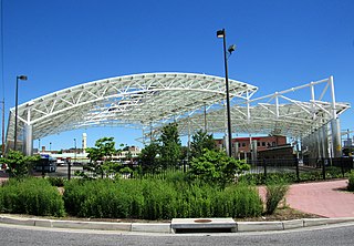
The Takoma Langley Crossroads Transit Center is a bus transit center in Langley Park, Maryland. It is at the intersection of University Boulevard and New Hampshire Avenue, and is the largest bus-only transfer in the Washington, D.C. metropolitan area. It is a future transfer point for the Purple Line.
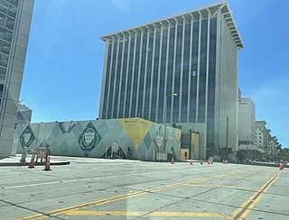
Wilshire/Rodeo station is an under construction, underground rapid transit station on the D Line of the Los Angeles Metro Rail system. It is currently under construction as part of the D Line Extension project, in Beverly Hills, California. Construction started in 2018 as part of Section 2 of the extension project. It is slated to open in 2026.
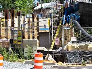
Manchester Place is a light rail station that is currently under construction. It will be part of the Purple Line in Maryland. The station will be located underground in between Wayne Avenue and Plymouth Street.

Long Branch is a light rail station that is currently under construction in the Long Branch neighborhood of Silver Spring, Maryland. It will be part of the Purple Line in Maryland. The station will be located at Arliss Street and Piney Branch Road, adjacent to the Long Branch Library.

Piney Branch Road is a light rail station that is currently under construction. It will be part of the Purple Line in Maryland. The station will be located at the intersection of Piney Branch Road and University Boulevard.
Adelphi Road–UMGC–UMD is a light rail station that is currently under construction. It will be part of the Purple Line in Maryland. The station will be located on the west border of the University of Maryland at the intersection of Adelphi Road and Campus Drive.

Campus Drive–UMD is a light rail station that is currently under construction. It will be part of the Purple Line in Maryland. The station will be located at the intersection of Campus Drive and Library Lane on the campus of the University of Maryland.
Baltimore Avenue–College Park–UMD is a light rail station that is currently under construction. It will be part of the Purple Line in Maryland. The station will be located at the intersection of Baltimore Avenue and Rossborough Lane on the eastern campus of the University of Maryland.
Riverdale Park North–UMD is a light rail station that is currently under construction. It will be part of the Purple Line in Maryland. The station will be located at the intersection of River Road and Haig Drive on the eastern campus of the University of Maryland in the M Square Research Park.
Beacon Heights–East Pines is a light rail station that is currently under construction. It will be part of the Purple Line in Maryland. The station will be located east of the intersection of Riverdale Road and 67th Avenue.
Glenridge is a light rail station that is currently under construction. It will be part of the Purple Line in Maryland, United States. The station will be located southwest of the intersection of Veterans Parkway and Annapolis Road.

The New Carrollton–Fort Totten Line, designated Route F6, is a weekday-only bus route operated by the Washington Metropolitan Area Transit Authority between the New Carrollton station of the Orange Line station of the Washington Metro and the Fort Totten station of the Red and Green Lines of the Washington Metro. The line operates every 30 minutes during peak hours and 60 minutes all other times, weekdays only. F6 trips are roughly 60 minutes. This route provides weekday service between Fort Totten and New Carrollton stations without having to take the train into Downtown DC.

The College Park–Bethesda Line, designated Route J4, was a rush hour-only MetroExtra bus route operated by the Washington Metropolitan Area Transit Authority between the College Park–University of Maryland station of the Green and Yellow Lines of the Washington Metro and Bethesda station of the Red Line of the Washington Metro. The J4 operated throughout the neighborhoods in Prince George's and Montgomery counties in Maryland. This line ran along current construction for the upcoming Purple Line between College Park and Bethesda.

The Riggs Road Line, designated as Routes R1 & R2, is a daily bus route operated by the Washington Metropolitan Area Transit Authority between Fort Totten station of the Red and Green Lines of the Washington Metro & Adelphi (R1) or Calverton (R2). Routes R1 & R2 operate every 20 minutes during peak hours and route R2 operates every 35-60 minutes at other times on weekdays, and 60 minutes on the weekends. R1 trips are roughly 32 minutes and R2 trips are roughly 55 minutes.
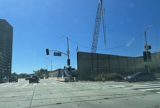
Westwood/UCLA station is an under construction, underground rapid transit station on the D Line of the Los Angeles Metro Rail system. The station will be located under Wilshire Boulevard between Veteran Avenue and Westwood Boulevard, with the main station entrance to the west of Gayley Avenue. Other entrances will be located on the north and south sides of Wilshire Boulevard and the west side of Westwood Boulevard.
