
Silver Spring station is a train station on the Red Line of the Washington Metro and the Brunswick Line of the MARC Train commuter rail system. The Metro station averaged 4,536 daily riders in 2023, making it the 19th-busiest stop in the network and the busiest in the state of Maryland. Trains travelling south from the station quickly cross the border into Washington, D.C., while northbound trains head underground and make their way further into Montgomery County.

New Carrollton station is a joint Washington Metro, MARC, and Amtrak station just outside the city limits of New Carrollton, Prince George's County, Maryland located at the eastern end of the Metro's Orange Line. The station will also serve as the eastern terminus of the Purple Line, currently under construction, and is adjacent to the Capital Beltway.

College Park–University of Maryland station is a Washington Metro station in Prince George's County, Maryland, on the Green Line. It also serves MARC's Camden Line, though only select trains stop at the station.
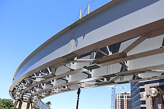
The Purple Line is a 16.2-mile (26.1 km) light rail line being built to link several Maryland suburbs of Washington, D.C.: Bethesda, Silver Spring, College Park, and New Carrollton. Currently slated to open in late 2027, the line will also enable riders to move between the Maryland branches of the Red, Green, and Orange lines of the Washington Metro without riding into central Washington, and between all three lines of the MARC commuter rail system. The project is administered by the Maryland Transit Administration (MTA), an agency of the Maryland Department of Transportation (MDOT), and not the Washington Metropolitan Area Transit Authority (WMATA), which operates Metro.
The Washington, Baltimore and Annapolis Trail (WB&A) is a 10.25-mile (16.50 km) long discontinuous rail trail from Lanham to Odenton in Maryland. Despite its name, it does not actually connect with Washington, D.C., Annapolis or Baltimore; its name is taken from the Washington, Baltimore and Annapolis Electric Railway, from which the right-of-way comes. The trail exists in two separate pieces, one in Anne Arundel County and the other in Prince George's County, separated by the lack of a bridge over the Patuxent River. The bridge's construction and the trail's alignment was delayed for over a decade due to a property dispute; however, the trail was realigned and plans exist to complete a bridge by 2021. Additional plans exist to extend the trail southward to the Washington, D.C. border.

Georgia Avenue is a major north-south artery in Northwest Washington, D.C., and Montgomery County, Maryland. In Washington, D.C., and for a short distance in Silver Spring, Maryland, Georgia Avenue is also U.S. Route 29. Howard University is located on Georgia Avenue.

Maryland Route 410 (MD 410) is a state highway in the U.S. state of Maryland and known for most of its length as East–West Highway. The highway runs east to west for 13.92 miles (22.40 km) from MD 355 in Bethesda east to Pennsy Drive in Landover Hills. MD 410 serves as a major east–west commuter route through the inner northern suburbs of Washington, D.C., connecting the commercial districts of Bethesda, Silver Spring, and Hyattsville. In addition, the highway serves the industrial area of Landover Hills and the residential suburbs of Chevy Chase, Takoma Park, Chillum, Riverdale, and East Riverdale. The road also connects many of the arterial highways and freeways that head out of Washington. Additionally, it provides a highway connection to transit and commercial hubs centered around Washington Metro subway stations in Bethesda, Takoma Park, Hyattsville, Silver Spring, and New Carrollton–the latter two of which provide additional connections to MARC and Amtrak trains.

Maryland Route 488 is a state highway in the U.S. state of Maryland. Known as La Plata Road, the state highway runs 6.01 miles (9.67 km) from MD 6 in La Plata east to MD 5 near Bryantown. MD 488 is a connector between La Plata and eastern Charles County, including the town of Hughesville. The state highway was constructed in the mid-1930s.
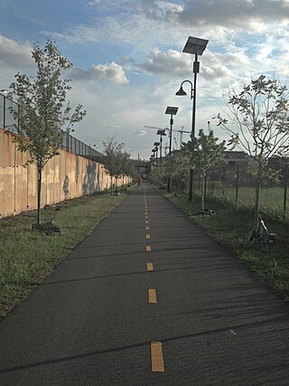
The Metropolitan Branch Trail is an American rail trail between the transit center in Silver Spring, Maryland, and Union Station in the District of Columbia. It runs for 8 miles (13 km): one in Maryland and seven within Washington, D.C. The trail parallels Metrorail and CSX tracks along a right-of-way opened in 1873 as the Baltimore and Ohio Railroad (B&O)'s Metropolitan Branch.
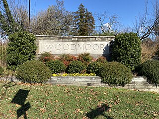
Woodmoor is a neighborhood in the northern section of Silver Spring, Maryland in southeastern Montgomery County, in the U.S. state of Maryland. Its borders extend from U.S. 29 to the west, Northwest Branch Park to the north, the Capital Beltway (I-95) to the east, and University Boulevard to the south. It lies on one of the "Four Corners" at the northeastern corner of the intersection of Colesville Road, and University Boulevard.

Maryland Route 320 is a state highway in the U.S. state of Maryland. Known as Piney Branch Road, the highway runs 2.84 miles (4.57 km) from Eastern Avenue at the District of Columbia boundary in Takoma Park north to MD 650 in Adelphi. MD 320 is a southwest–northeast highway that connects Takoma Park and Silver Spring in southeastern Montgomery County with Adelphi in far western Prince George's County. The state highway originally extended from downtown Silver Spring to White Oak and connected with U.S. Route 29 at both ends. The Silver Spring–Adelphi portion of the highway was constructed in 1910. The segment through Takoma Park and the Adelphi–White Oak segment, which later became MD 650, were built in the early 1930s; the Takoma Park portion was built as MD 513. MD 320 was widened over its whole length in the late 1940s and reduced to its present course in the mid-1950s.

Four Corners is a neighborhood and census-designated place (CDP) in Montgomery County, Maryland, United States. Many residents consider the neighborhood a part of Silver Spring, to whose CDP it belonged until 2010. It had a population of 8,316 at the 2020 census.

Maryland Route 594 is an unsigned state highway in the U.S. state of Maryland. Known as Wayne Avenue, the highway runs 1.40 miles (2.25 km) from U.S. Route 29 east to Flower Avenue within Silver Spring in southeastern Montgomery County. This segment is part of a collection of four auxiliary routes designated as MD 594 in the Silver Spring area. Wayne Avenue is designated MD 594A, while the three other auxiliary routes are designated MD 594B, MD 594C, and MD 594D. MD 594A, MD 594B, MD 594C, and MD 594D were transferred to the state from Montgomery County in 2016. MD 594E and MD 594F, which were located in Prince George's County, were transferred to the state from the county in 2017. In 2019, MD 594E and MD 594F were renumbered to MD 431 and MD 433 respectively.
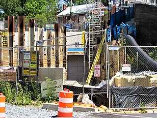
Manchester Place is a light rail station that is currently under construction. It will be part of the Purple Line in Maryland. The station will be located underground in between Wayne Avenue and Plymouth Street.

Piney Branch Road is a light rail station that is currently under construction. It will be part of the Purple Line in Maryland. The station will be located at the intersection of Piney Branch Road and University Boulevard.
Riggs Road is a light rail station that is currently under construction. It will be part of the Purple Line in Maryland. The station will be located at the intersection of Riggs Road and University Boulevard.
Adelphi Road–UMGC–UMD is a light rail station that is currently under construction. It will be part of the Purple Line in Maryland. The station will be located on the west border of the University of Maryland at the intersection of Adelphi Road and Campus Drive.
Beacon Heights–East Pines is a light rail station that is currently under construction. It will be part of the Purple Line in Maryland. The station will be located east of the intersection of Riverdale Road and 67th Avenue.
Glenridge is a light rail station that is currently under construction. It will be part of the Purple Line in Maryland, United States. The station will be located southwest of the intersection of Veterans Parkway and Annapolis Road.

Franklin Knolls is a residential neighborhood located in Silver Spring, a census-designated place in Montgomery County.

