Patterson Park

Last updated

Patterson Park
Patterson Park October Aerial.jpg
Patterson Park in October
Patterson Park
Type Public park
Location Baltimore, Maryland
Coordinates 39°17′16″N76°34′43″W / 39.28778°N 76.57861°W / 39.28778; -76.57861 [1] [2]
Created1827

Patterson Park is an urban park in Southeast Baltimore, Maryland, United States, adjacent to the neighborhoods of Canton, Highlandtown, Patterson Park, and Butchers Hill. It is bordered by East Baltimore Street, Eastern Avenue, South Patterson Park Avenue, and South Linwood Avenue. The Patterson Park extension lies to the east of the main park, and is bordered by East Pratt Street, South Ellwood Avenue, and Eastern Avenue.

Contents

Patterson Park was established in 1827 and named for William Patterson (1752–1835). The park consists of open fields of grass, large trees, paved walkways, historic battle sites, a lake, playgrounds, athletic fields, a swimming pool, an ice skating rink and other signature attractions and buildings. [3] At 137 acres (0.55 km2), Patterson Park is not the city's largest park; however, it is nicknamed "Best Backyard in Baltimore." [4]

Attractions and activities

The "Observatory" a pagoda-style building on Hampstead Hill, overlooking the rest of the park. Patterson Park Observatory Bmore.JPG
The "Observatory" a pagoda-style building on Hampstead Hill, overlooking the rest of the park.

Patterson Park has four main entrances at each corner. Its notable attractions include the boat lake (where fishing is permitted), the marble fountain, the Pulaski Monument, and the Patterson Park Observatory [5] [6] The Patterson Park Observatory was built in 1891 as an observation tower for viewing the city and is still open to visitors. [7] The park is also home to the Virginia S. Baker Recreation Center. [8] [9]

The park has smooth pathways suitable for biking and jogging. The sports fields are open for use to anyone who wants to play a game, and there are public tennis courts as well. [4] [10] There are two playgrounds for children [11] as well as a fenced-in dog park. [12] There is a swimming pool open during the summer [10] and an ice skating rink that operates during winter. [13] From spring to early autumn, several festivals are held in the park. [14] The neighborhood surrounding the park is part of an innovative urban renewal campaign by the city and neighborhood leaders. [15]

Nature

General Casimir Pulaski Monument Pulaski-Szmurlo.jpg
General Casimir Pulaski Monument

There are no heavily forested areas of Patterson Park; however, there are plenty of open spaces. The boat lake, reconstructed in 2001 and set for a small renovation in 2022, is inhabited mostly by mallard ducks and nesting Green Heron, but its avian visitors include American Coots and Wood Ducks. Great Blue Heron and Black-crowned Night-Heron are occasionally seen on the lake. There are also fish, frogs, and turtles in the lake.

History

The high ground at the northwest corner of Patterson Park, called Hampstead Hill, was the key defensive position for U.S. forces against British ground forces in the Battle of Baltimore during the War of 1812. The redoubt was known as Rodgers Bastion, or Sheppard's Bastion, and was the centerpiece of the earthen line dug to defend the eastern approach to Baltimore, from the outer harbor in Canton north to Belair Road. On September 13, 1814, the day after the Battle of North Point, some 4,300 British troops advanced north on North Point Road, then west along the Philadelphia Road toward Baltimore, forcing U.S. troops to retreat to the defensive line. When the British began probing actions, the American line was defended by 100 cannon and more than 10,000 troops. The American defenses were far stronger than anticipated, and U.S. defenders at Fort McHenry successfully stopped British naval forces from advancing close enough to lend artillery support, and British attempts to flank the defense were countered. Thus, before dawn on September 14, 1814, British commander Colonel Arthur Brooke decided the land campaign was a lost cause, and ordered the retreat back to the ships, and the United States was thus victorious in the Battle of Baltimore. [16] [17] [18]

William Patterson (d. 1835), a Baltimore merchant, donated 5 acres (20,000 m2) to the city for a public walk in 1827, and the city purchased 29 acres (120,000 m2) additional from the Patterson family in 1860. [19] Additions and improvements to the park made after 1859 were funded through the city's "park tax" on its streetcars, which was initially set at 20% of the fare. [20] During the Civil War, the site was used as a Union troop encampment. Additional purchases in later years increased the park size to its present 137 acres (0.55 km2).

Several public accommodations at the park such as the swimming pools, picnic pavilions, and playgrounds were managed as "separate but equal" until they were desegregated in 1956. [21] The park is included in the Baltimore National Heritage Area. [22]

On October 10, 1962, President John F. Kennedy visited Baltimore and landed in his helicopter at the park and took an open top car to the 5th Regiment Armory. [23] He was in town prior to the midterm elections to stump for the Democratic ticket.

Patterson Park Observatory

Patterson Park Observatory lit up during Christmas Pagoda Christmas Lights (cropped).jpg
Patterson Park Observatory lit up during Christmas

The 60-foot (18 m) Observatory, previously known as the Pagoda, was designed in 1890 and completed in 1892 by Charles H. Latrobe who was the general superintendent and engineer under the Park Commission, led along with architect George A. Frederick, who also designed Baltimore City Hall. [24] It was designed as a people's lookout tower with an Asian motif, inspired by Latrobe's fascination with the East. [25] The Observatory was designated as a Baltimore City Landmark in 1982. [26]

Related Research Articles

<span class="mw-page-title-main">Central Park</span> Public park in Manhattan, New York

Central Park is an urban park between the Upper West Side and Upper East Side neighborhoods of Manhattan in New York City, United States. It is the fifth-largest park in the city, containing 843 acres (341 ha), and the most visited urban park in the United States, with an estimated 42 million visitors annually as of 2016.

<span class="mw-page-title-main">Enoch Pratt Free Library</span> Building

The Enoch Pratt Free Library is the free public library system of Baltimore, Maryland. Its Central Library and office headquarters are located on 400 Cathedral Street (southbound) and occupy the northeastern three quarters of a city block bounded by West Franklin Street to the north, Cathedral Street to the east, West Mulberry Street to the south, and Park Avenue (northbound) to the west. Located on historic Cathedral Hill, north of downtown, the library is also in the Mount Vernon-Belvedere-Mount Royal neighborhood and cultural and historic district.

<span class="mw-page-title-main">Prospect Park (Brooklyn)</span> Public park in Brooklyn, New York

Prospect Park is an urban park in Brooklyn, New York City. The park is situated between the neighborhoods of Park Slope, Prospect Heights, Prospect Lefferts Gardens, Flatbush, and Windsor Terrace, and is adjacent to the Brooklyn Museum, Grand Army Plaza, and the Brooklyn Botanic Garden. With an area of 526 acres (213 ha), Prospect Park is the second largest public park in Brooklyn, behind Marine Park. Designated as a New York City scenic landmark and listed on the National Register of Historic Places, Prospect Park is operated by the Prospect Park Alliance and NYC Parks.

<span class="mw-page-title-main">High Park</span> Urban park in Toronto, Canada

High Park is a municipal park in Toronto, Ontario, Canada. High Park is a mixed recreational and natural park, with sporting facilities, cultural facilities, educational facilities, gardens, playgrounds and a zoo. One-third of the park remains in a natural state, with a rare oak savannah ecology. High Park was opened to the public in 1876 and is based on a bequest of land from John George Howard to the City of Toronto. It spans 161 hectares and is the second-largest municipal park in Toronto, after Centennial Park.

<span class="mw-page-title-main">Morningside Park (Manhattan)</span> Public park in Manhattan, New York

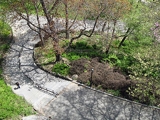
Morningside Park is a 30-acre (12-hectare) public park in Upper Manhattan, New York City. The park is bounded by 110th Street to the south, 123rd Street to the north, Morningside Avenue to the east, and Morningside Drive to the west. A cliff made of Manhattan schist runs through the park and separates Morningside Heights, above the cliff to the west, from Harlem. The park includes other rock outcroppings; a man-made ornamental pond and waterfall; three sculptures; several athletic fields; playgrounds; and an arboretum. Morningside Park is operated by the New York City Department of Parks and Recreation, although the group Friends of Morningside Park helps maintain it.

<span class="mw-page-title-main">McCarren Park</span> Public park in Brooklyn, New York

McCarren Park is a public park in Brooklyn, New York City. It is located on the border of Williamsburg and Greenpoint and is bordered by Nassau Avenue, Bayard Street, Lorimer Street and North 12th Street. The park contains facilities for recreational softball, volleyball, soccer, handball, and other games. It is also used for sunbathing and dog-walking. It also includes the McCarren Play Center, which consists of a recreation center and a pool. McCarren Park is maintained by the New York City Department of Parks and Recreation.

<span class="mw-page-title-main">McElderry Park, Baltimore</span> Neighborhood of Baltimore in Maryland, United States

McElderry Park is a neighborhood in the northern part of the southeastern district of the City of Baltimore. Its boundaries are marked by East Fayette Street, East Monument Street, Linwood Avenue, and Patterson Park Avenue. South of McElderry Park is the neighborhood of Patterson Park; Butchers Hill is to the southwest. Ellwood Park is located to the east, and the campus of The Johns Hopkins Hospital to the west. To its north is the neighborhood of Madison-East End.

<span class="mw-page-title-main">Highbridge Park</span> Public park in Manhattan, New York

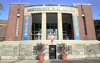
Highbridge Park is a public park on the western bank of the Harlem River in Washington Heights, Manhattan, New York City. It stretches between 155th Street and Dyckman Street in Upper Manhattan. The park is operated by the New York City Department of Parks and Recreation. The City maintains the southern half of the park, while the northern half is maintained by the non-profit New York Restoration Project. Prominent in the park are the Manhattan end of the High Bridge, the High Bridge Water Tower, and the Highbridge Play Center.

<span class="mw-page-title-main">Astoria Park</span> Public park in Queens, New York

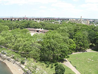
Astoria Park is a 59.96-acre (24.26 ha) public park in the Astoria neighborhood of Queens in New York City. The park is situated on the eastern shore of the Hell Gate, a strait of the East River, between Ditmars Boulevard to the north and Hoyt Avenue to the south. The Robert F. Kennedy (Triborough) and Hell Gate Bridges respectively pass over the park's southern and northern sections. Astoria Park contains a playground, a soccer field, a running track, a skate park, and courts for tennis, basketball, and bocce. Astoria Park also includes the Astoria Play Center, which consists of a recreation center and a pool. The park and play center are maintained by the New York City Department of Parks and Recreation.

<span class="mw-page-title-main">Crotona Park</span> Public park in the Bronx, New York

Crotona Park is a public park in the South Bronx in New York City, covering 127.5 acres (51.6 ha). The park is bounded by streets of the same name on its northern, eastern, southern, and western borders, and is adjacent to the Crotona Park East and Morrisania neighborhoods of the Bronx. It is divided into four portions by Claremont Parkway and Crotona Avenue, which run through it.

<span class="mw-page-title-main">Clifton Park, Baltimore</span> United States historic place

Clifton Park is a public urban park and national historic district located between the Coldstream-Homestead-Montebello and Waverly neighborhoods to the west and the Belair-Edison, Lauraville, Hamilton communities to the north in the northeast section of Baltimore, Maryland, United States. It is roughly bordered by Erdman Avenue to the northeast, Sinclair Lane to the south, Harford Road to the northwest and Belair Road to the southeast. The eighteen-hole Clifton Park Golf Course, which is the site of the annual Clifton Park Golf Tournament, occupies the north side of the park.

<span class="mw-page-title-main">Lake Roland (park)</span> United States historic place

Lake Roland is a city/county park encompassing over 500 acres of woodland, wetlands, serpentine barrens, rare plants and rocky plateaus surrounding Lake Roland in Baltimore County, Maryland. The park is located near the intersection of Falls Road and Lake Avenue, adjacent to the Falls Road Light Rail Stop of the Baltimore Light Rail, which runs from Cromwell Station near Glen Burnie in Anne Arundel County in the south to Hunt Valley of Baltimore County. The line runs along a railroad embankment and trestle over the lake above the dam, cutting the park into a two-thirds wooded northern part and the one-third southern portion around the dam, picnic groves, pavilion and pumping station.

<span class="mw-page-title-main">The Pond and Hallett Nature Sanctuary</span> Geographical features in New York Citys [[Central Park]]

Federal Hill Park is a 10.3 acres park located in Baltimore, Maryland on the south shore of the Inner Harbor. The park is a signature Baltimore landmark and offers visitors some of the most noted views in the city often photographed looking north to the downtown skyline of skyscrapers across the Inner Harbor of the Northwest Branch of the Patapsco River / Baltimore Harbor. The Federal Hill surrounding neighborhood to the west and south is named for the prominent hill and is also known as old South Baltimore. The now graded grass lawn hill and park, was originally a jagged cliffs and bluffs of red clay which was mined in the 18th and 19th centuries after being first sighted and described by Captain John Smith of England on his voyages of exploration of the Chesapeake Bay from the first English colony at Jamestown, Virginia in 1608. The noted famous site today is bounded by Francis Scott Key Highway along the waterfront to the north, Battery Avenue to the west, Warren Avenue to the south, and Covington Street to the east. Baltimore city acquired the hill as public property in 1880 after it was used and fortified as a fort with heavy artillery by the Union Army during the American Civil War (1861-1865). It was established then as a city park operated and maintained by the city Department of Recreation and Parks.

<span class="mw-page-title-main">Patterson Park (neighborhood), Baltimore</span> United States historic place

Patterson Park is a neighborhood in Baltimore, Maryland, United States. Named for the 137-acre park that abuts its north and east sides, the neighborhood is in the southeast section of Baltimore city, roughly two miles east of Baltimore's downtown district.

<i>Telegraf</i> (Baltimore newspaper) Defunct newspaper in Baltimore, Maryland, US

The Telegraf was a local weekly newspaper published in Baltimore, Maryland. The newspaper ran for 42 years, from February 20, 1909, until 1951. It was directed at the Czech community in Baltimore and was published in Czech. The newspaper was founded and first published by Vaclav Joseph Shimek, who also founded the Grand Lodge Č.S.P.S. of Baltimore. After 1929, the newspaper was edited by the Rev. Frank Novak and published by August Klecka.

<span class="mw-page-title-main">William Patterson (Maryland businessman)</span>

William Patterson (1752–1835) was a businessman, a gun-runner during the American Revolution, and a founder of the Baltimore and Ohio Railroad. His many business dealings included shipping, banking, and the Baltimore Water Company.

<span class="mw-page-title-main">Baltimore riots of 1919</span> Series of riots connected to the Red Summer of 1919

The Baltimore riots of 1919 were a series of riots connected to the Red Summer of 1919. As more and more African-Americans moved from the south to the industrial north they started to move into predominantly white neighborhoods. This change in the racial demographics of urban areas increased racial tension that occasionally boiled over into civil unrest.

<span class="mw-page-title-main">North Woods and North Meadow</span> Geographical features in New York Citys Central Park

<span class="mw-page-title-main">Concert Grove</span> Prospect Park sculpture garden

The Concert Grove is a section of Prospect Park, Brooklyn, New York City, that historically functioned as an outdoor music venue. It still serves as a sculpture garden lined with busts of musical figures, largely put up by German American Sängerfest participants and other cultural groups. The Concert Grove also includes the Concert Grove Pavilion, formerly known as the Oriental Pavilion, and adjoins a Lincoln sculpture facing the lake.

References

  1. "Patterson Park". Geographic Names Information System . United States Geological Survey, United States Department of the Interior. September 12, 1979. Retrieved May 26, 2020.
  2. "Patterson Park". GeoNames.org . Retrieved May 26, 2020.
  3. Harnik, Peter (2002), The Best Backyard in Baltimore (PDF), Washington, DC: The Trust for Public Land Center for City Park Excellence, retrieved March 30, 2016
  4. 1 2 Collins, Dan (December 18, 2008). "Patterson Park: Best backyard in Baltimore". Washington Examiner . Retrieved March 30, 2016.
  5. Almaguer 2006, p. 37, 42, 111.
  6. "Friends of Patterson Park: What's In a Name?". Friends of Patterson Park. July 9, 2021. Retrieved December 12, 2021.
  7. Taylor, Barbara Haddock (February 28, 2014). "Patterson Park Pagoda: Asian influence in Southeast Baltimore". The Baltimore Sun . ISSN   1943-9504. OCLC   244481759 . Retrieved March 29, 2016.
  8. Almaguer, Tim (2006). Baltimore's Patterson Park. Images of America series. Tim Almaguer on behalf of the Friends of Patterson Park. Charleston, SC: Arcadia Publishing. p. 107. ISBN   978-0-7385-4365-9. LCCN   2006931585. OCLC   76893485. OL   7902041M via Google Books.
  9. "Virginia Baker Recreation Center". pattersonpark.com. Friends of Patterson Park. Retrieved March 30, 2016.
  10. 1 2 Kelly, Jacques (August 7, 2015). "Patterson Park buzzes with activity in the summer". The Baltimore Sun . ISSN   1943-9504. OCLC   244481759 . Retrieved March 30, 2016.
  11. "Places in the Park: Playgrounds". pattersonpark.com. Friends of Patterson Park. Retrieved March 30, 2016.
  12. "Patterson Park opens new dog park". www.wbaltv.com. WBAL-TV Baltimore. December 17, 2012. Retrieved March 29, 2016.
  13. Salinas, Sara (June 17, 2015). "Patterson Park redesign would eliminate Mimi DiPietro ice rink". Baltimore Business Journal. Retrieved March 30, 2016.
  14. "Community Events". pattersonpark.com. Friends of Patterson Park. Retrieved March 30, 2016.
  15. "Patterson Park". www.cityparksalliance.org. City Parks Alliance. 2016. Retrieved March 30, 2016.
  16. Alden, Henry Mills, ed. (March 1864). "Scenes in the War of 1812". Harper's New Monthly Magazine . Vol. 28. New York, NY: Harper & Brothers. pp. 433–449. hdl:2027/njp.32101064075532. ISSN   0361-8277. OCLC   818988304 via Google Books.
  17. Young, Kevin (September 1, 2005). Written at Fort Meade, Md.. "The Battle of Baltimore Sept. 12 to 15, 1814". Soundoff!. Baltimore: Patuxent Publishing and Baltimore Sun Media Group. Archived from the original on December 25, 2010.
  18. Jensen, Brennen (September 22, 1999). "1812 Overtures: The New Battle of Baltimore Is Reminding Americans About the City's Finest Star-Spangled Hour". City Paper . Baltimore. ISSN   0740-3410. OCLC   9930226. Archived from the original on March 24, 2012.
  19. Almaguer 2006, p. 9, 29.
  20. Farrell, Michael R. (1992). The History of Baltimore's Streetcars. With additional material by Herbert H. Harwood, Jr. and Andrew S. Blumberg. Sykesville, Md.: Greenberg Publishing Co. pp. 4–6, 23, 139–40. ISBN   978-0-8977-8283-8. LCCN   92008474. OCLC   25548091. OL   1707017M via Google Books.
  21. Almaguer 2006, p. 68.
  22. "Baltimore National Heritage Area Map" (PDF). City of Baltimore. Archived from the original (PDF) on May 22, 2013. Retrieved March 11, 2012.
  23. "Kennedy Visits Patterson Park in '62". GhostsOfBaltimore.org. November 12, 2013. Retrieved March 4, 2019.
  24. Lantz, Emily Emerson (March 14, 1920). "Designer of City Hall, Still Hale and Hearty, Tells of His Long Career". The Sun . Baltimore. p. 8B. ISSN   1930-8965. OCLC   7909813.
  25. Kelly, Jacques (April 25, 2002). "Patterson Park pagoda, good as new". The Sun . Baltimore. p. 3T. ISSN   2573-2536. OCLC   1076792972.
  26. Patterson Park Observatory Landmark Designation Report (PDF) (Report). City of Baltimore. September 1971. Retrieved May 26, 2020.