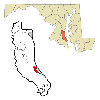
St. Leonard is a census-designated place (CDP) in Calvert County, Maryland, United States. The population was 742 at the 2010 census. Residents of the Calvert Beach and Long Beach communities also use the St. Leonard ZIP code designation. St. Leonard has a large antique dealer complex.

Cape Henlopen State Park is a Delaware state park on 5,193 acres (2,102 ha) on Cape Henlopen in Sussex County, Delaware, in the United States. William Penn made the beaches of Cape Henlopen one of the first public lands established in what has become the United States in 1682 with the declaration that Cape Henlopen would be for "the usage of the citizens of Lewes and Sussex County." Cape Henlopen State Park has a 24-hour and year-round fishing pier as well as campgrounds. The remainder of the park is only open from sunrise to sunset, and includes a bathhouse on the Atlantic Ocean, an area for surf-fishing, a disc golf course, and bicycle and walking paths. The beach at Herring Point is a popular surfing spot. The park is a stop on Delaware's Coastal Heritage Greenway.

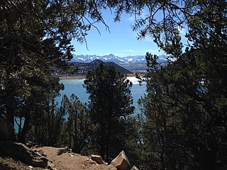
Deep Creek Lake State Park is a state-operated, public recreation area along a small section of Deep Creek Lake in Garrett County, Maryland, in the United States. The park features water activities, camping facilities, and recreational trails and is located about 18 miles (29 km) south of Interstate 68 on U.S. Route 219.
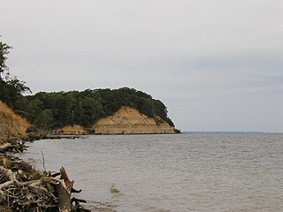
Calvert Cliffs State Park is a public recreation area in Lusby, Calvert County, Maryland, that protects a portion of cliffs that extend for 24 miles along the eastern flank of the Calvert Peninsula on the west side of Chesapeake Bay from Chesapeake Beach southward to Drum Point. The state park is known for the abundance of mainly Middle Miocene sub-epoch fossils that can be found on the shoreline.
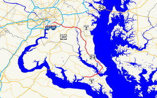
Maryland Route 4 is a state highway in the U.S. state of Maryland. The highway runs 64.85 miles (104.37 km) from MD 5 in Leonardtown north to Southern Avenue in Suitland at the District of Columbia boundary, beyond which the highway continues into Washington as Pennsylvania Avenue. MD 4 is a four- to six-lane highway that connects Washington and communities around the Capital Beltway with southern Prince George's County with southwestern Anne Arundel County. The highway is the primary highway for the length of Calvert County, during most of which the route runs concurrently with MD 2. MD 4 also connects Calvert and St. Mary's counties via the Governor Thomas Johnson Bridge across the Patuxent River. The highway connects the Southern Maryland county seats of Leonardtown, Prince Frederick, and Upper Marlboro.

Grafton Lakes State Park is a 2,545-acre (10.30 km2) state park located in Rensselaer County, New York, United States. The park is in the central part of the Town of Grafton and north of the hamlet of Grafton on NY Route 2, northeast of Albany. The park contains the Shaver Pond Nature Center.
Point Lookout State Park is a Maryland state park occupying Point Lookout, the southernmost tip of a peninsula formed by the confluence of Chesapeake Bay and the Potomac River in St. Mary's County, Maryland. The state park preserves the site of an American Civil War prisoner of war camp and the Point Lookout Light, which was built in 1830. It is the southernmost spot on Maryland's western shore, the coastal region on the western side of the Chesapeake Bay.

Dan's Mountain State Park is a public recreation area located nine miles (14 km) south of Frostburg and to the east of the town of Lonaconing in Allegany County, Maryland. The state park occupies 482 acres (195 ha) on 16-mile-long (26 km) Dans Mountain and is managed by the Maryland Department of Natural Resources.
Ridgway State Park is a state park located in Ouray County, Colorado. It is the westernmost state park in Colorado. The park is 21 miles southeast of Montrose, 14 miles northeast of Ouray, it is also 4 miles north of the town of Ridgway and 312 miles southwest of Denver. The current wildlife consists of deer, coyotes, rabbits, and elk. Due to the park's variety of animal life, the park is used as a hunting ground although hunting opportunities are extremely limited due to proximity to developed areas.

Lums Pond State Park is a 1,790-acre (720 ha) Delaware state park near Bear, New Castle County, Delaware in the United States. The park surrounds Lums Pond, an impoundment built by the Chesapeake and Delaware Canal on St. Georges Creek. The C&D built the pond as a source of water to fill the locks of the canal that connected the Chesapeake Bay with the Delaware River during the early 19th century. Lums Pond State Park is open for a wide variety of year-round recreation.

Fenwick Island State Park is a 344-acre (139 ha) Delaware state park between Ocean City, Maryland and South Bethany, Delaware in Sussex County, Delaware, US. Fenwick Island State Park is open for year-round recreation from 8:00 am until sunset. Originally part of Delaware Seashore State Park, it was established in 1966 and renamed in 1981. The park is located on Fenwick Island, a narrow strip of land between the Atlantic Ocean and Little Assawoman Bay. It is largely undeveloped in comparison to the beach communities that surround it.

Elk Neck State Park is a public recreation area located between Chesapeake Bay and the Elk River near the southern tip of the Elk Neck Peninsula in Cecil County, Maryland. The state park is home to the historic Turkey Point Light and offers land-based and water-based recreation. The park is located on MD 272, eight miles (13 km) south of the town of North East, and 13 miles (21 km) south of exit 100 on I-95. It is operated by the Maryland Department of Natural Resources.

Battle Creek Cypress Swamp (BCCS) is a forested wetland near Prince Frederick in Calvert County, Maryland, United States. It is one of the northernmost sites of naturally occurring bald cypress trees in North America, and the only large stand of the trees on the western shore of Maryland. In 1965, the National Park Service designated the BCCS a National Natural Landmark.

Sandy Point State Park is a public recreation area located on Sandy Point at the western end of the Chesapeake Bay Bridge in Anne Arundel County, Maryland. The state park grounds include the Sandy Point Farmhouse, listed on the National Register of Historic Places in 1972, which is undergoing restoration and is not open to the public. The historic Sandy Point Shoal Light stands in about five feet of water some 1,000 yards (910 m) east of the park's beach.

New Germany State Park is a public recreation area covering 483 acres (195 ha) adjacent to Savage River State Forest in Garrett County, Maryland. The state park is administered by the Maryland Department of Natural Resources.
Pocomoke River State Park is a public recreation area lying on both banks of the Pocomoke River between Snow Hill and Pocomoke City in Worcester County, Maryland. The state park comprises two areas within Pocomoke State Forest: Shad Landing on the south bank of the river and Milburn Landing on the north bank.
Gunpowder Falls State Park is a public recreation area comprising six non-contiguous areas covering 18,000 acres (7,300 ha) in northeastern Baltimore County and western Harford County, Maryland. The state park is primarily made up of the stream valleys of the Big and Little Gunpowder Falls and the Gunpowder River; its natural features range from tidal marshes to rugged interior slopes. The park has over 120 miles of trails for hiking, biking, horseback riding, and cross-country skiing plus facilities for picnicking, tubing, canoeing and kayaking, tide-water fishing and crabbing, fly fishing, and hunting, among other activities. It is managed by the Maryland Department of Natural Resources.

Greenbrier State Park is a public recreation area located on South Mountain near Boonsboro in Washington County, Maryland, USA. The state park has camping, hiking trails, and a 42-acre (17 ha) man-made lake. It is managed by the Maryland Department of Natural Resources.
Zekiah Swamp is part of the Potomac River basin in Charles County, Maryland in the United States. The swamp is 21 miles (34 km) of braided stream stretching the length of Charles County and is a tributary of the Potomac River. It sits at an elevation of three feet (0.91 m) and 450 acres (180 ha) of its southern end is protected as the Zekiah Swamp Natural Environment Area. The Maryland Department of Natural Resources has the authority to purchase an additional 5,000 acres (2,000 ha) for the park. Charles County has moved to protect an additional 65,000 acres (26,000 ha) of the wetland. The headwaters of the swamp are protected as part of Cedarville State Forest. It was first accurately surveyed by John Henry Alexander, Maryland's official cartographer, in 1835, as "Allen's Fresh".
Collington Branch is a stream that flows into the Western Branch of the Patuxent River in Prince George's County, Maryland.


