List of National Park System areas in Maryland

Last updated

This list of National Park System areas in Maryland includes the lands, trails, or park networks maintained by the National Park Service of the United States within the U.S. State of Maryland. The National Park Service controls 24 units in the state of Maryland. They range from sites of historical interest to sites of ecological interest to portions of the parkway system around Washington, DC. Many of the sites currently under the control of the National Park Service in Maryland were previously under the control of other agencies in the federal government, such as Antietam National Battlefield, which was originally managed by the Department of War. [1] There are eight units administered by the National Park System as part of the National Capital Parks. The most recent unit created in Maryland is the Captain John Smith Chesapeake National Historic Trail, which was authorized by Congress in 2006.

Contents

National Park System areas

A view of Antietam National Battlefield, site of one of the bloodiest battles of the American Civil War Antietemnb.jpg
A view of Antietam National Battlefield, site of one of the bloodiest battles of the American Civil War
The C&O Canal at Swain's Lock. The canal runs between Washington, DC and Cumberland, Maryland. Canal swains lock 20040911 121236 2.jpg
The C&O Canal at Swain's Lock. The canal runs between Washington, DC and Cumberland, Maryland.
The sally port, or main entrance, to Fort McHenry in Baltimore. The Battle of Fort McHenry in the War of 1812 inspired Francis Scott Key to write the Star Spangled Banner. FtMcHenryEntrance.JPG
The sally port, or main entrance, to Fort McHenry in Baltimore. The Battle of Fort McHenry in the War of 1812 inspired Francis Scott Key to write the Star Spangled Banner.
Close-up view of sign on the former bumper car pavilion at Glen Echo Park GlenEcho BumperCarPavilionSign.JPG
Close-up view of sign on the former bumper car pavilion at Glen Echo Park
Farmhouse and slave quarters at Hampton National Historic Site. Photo by James G. Howes. Hampton NHS 03-cropped.jpg
Farmhouse and slave quarters at Hampton National Historic Site. Photo by James G. Howes.
View of the Potomac River at Piscataway Park Piscataway park.jpg
View of the Potomac River at Piscataway Park
Haberdaventure, the home of Thomas Stone, a signer of the Declaration of Independence, centerpiece of the Thomas Stone National Historic Site. Thomasstonenhs.jpg
Haberdaventure, the home of Thomas Stone, a signer of the Declaration of Independence, centerpiece of the Thomas Stone National Historic Site.
NameLocationDescriptionEstablishedNotes
Antietam National Battlefield Washington County Site of the Battle of Antietam (Civil War)1890 [B] [2]
Appalachian National Scenic Trail Washington County 2,175 mi (3,500 km) footpath stretching through 14 eastern states from Maine to Georgia. [3] 1970 [4]
Assateague Island National Seashore Worcester County 37 mi (60 km) long barrier island managed to conserve its plants and animals. [5] 1965 [6]
Baltimore–Washington Parkway [A] Anne Arundel and Prince George's Counties29 mi (47 km) highway connecting Washington, DC with Baltimore, Maryland. [7] 1954 [6]
Captain John Smith Chesapeake National Historic Trail Chesapeake Bay Water trail tracing Smith's explorations of the Chesapeake Bay, accessible from many points on Maryland's Chesapeake shoreline. [8] 2006 [8]
Catoctin Mountain Park Frederick County 5,810-acre (23.5 km2) forest park in the Appalachian Mountains. [9] 1954 [6]
Chesapeake and Ohio Canal National Historical Park Montgomery, Frederick, Washington, and Allegany CountiesPark paralleling the Potomac River, preserving remains of the Chesapeake and Ohio Canal. [10] 1938 [6]
Chesapeake Bay Gateways Network Chesapeake Bay shorelineNetwork of sites of historic and environmental interest across the Chesapeake Bay watershed. [11] 1998 [11]
Clara Barton National Historic Site Montgomery County Home of Clara Barton (1821–1912), the founder of the American Red Cross.1975 [12]
Fort Foote Park [A] Prince George's County Wood and earthwork fort on the Potomac River that formed part of Washington, DC's military defenses in the Civil War era.c. 1946 [13]
Fort McHenry National Monument and Historic Shrine Baltimore City Star-shaped fort that successfully defended Baltimore Harbor from an attack by the British navy during the War of 1812, in the battle that inspired Francis Scott Key to write The Star-Spangled Banner.1925 [6]
Fort Washington Park [A] Prince George's County Had a long history of military use as a defensive fort protecting Washington, DC 1946 [6]
George Washington Memorial Parkway Montgomery County Parkway in Virginia and Washington, DC; the short Clara Barton Parkway section connects to Glen Echo Park and the Clara Barton National Historic Site in Maryland1930 [6]
Glen Echo Park Montgomery County Park was first established in 1891 as a National Chautauqua Assembly; later it became an amusement park, which closed in 1968.1971 [14]
Greenbelt Park [A] Prince George's County A 1,176-acre (476 ha) recreational area within an urban environment. [15] 1950 [6]
Hampton National Historic Site Baltimore County 18th century estate including Georgian manor house, gardens and grounds, and original stone slave quarters1948 [6]
Harmony Hall [A] Prince George's County 18th-century country house surrounded by 65 acres (26 ha) of parkland. [16] 1966 [17]
Monocacy National Battlefield Frederick County Civil War battlefield straddling the Monocacy River southwest of Frederick.1976 [6]
Oxon Cove Park and Oxon Hill Farm [A] Prince George's County Located in Washington, DC and Prince George's County, Maryland, Oxon Cove Park provides recreational activities. [18] 1959 [19]
Piscataway Park [A] Prince George's County Across the Potomac River from Mount Vernon, established to protect the view from Mount Vernon.1961 [6]
Potomac Heritage National Scenic Trail Potomac River shorelineNetwork of trails along the Potomac River and its tributaries, from the mouth of the river near St. Mary's County to the headwaters.1983 [6]
Suitland Parkway [A] Prince George's County 9.35 mi (15 km) historic parkway built during World War II to connect Washington, DC-area military facilities1944 [6]
Thomas Stone National Historic Site Charles County Home and estate of Thomas Stone, a signer of the Declaration of Independence 1978 [6]

See also

Notes

A ^ Part of the National Capital Parks. [7] [20] [21] [22] [23]
B ^ Antietam National Battlefield was originally two separate units, a cemetery established in 1865 and the battlefield established in 1890 under the War department. Both the battlefield and the cemetery were transferred to the National Park Service from the War Department in 1933, and the two units were combined in 1974. [1]

Related Research Articles

Sharpsburg, Maryland Town in Maryland, United States

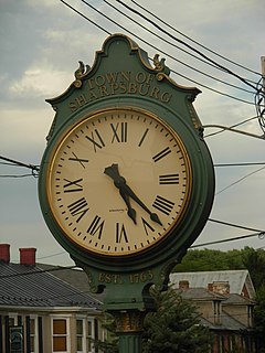
Sharpsburg is a town in Washington County, Maryland, United States, located approximately 13 miles (21 km) south of Hagerstown. The population was 705 at the 2010 census.

Natchez Trace Parkway National parkway in the southeastern U.S.

The Natchez Trace Parkway is a national parkway in the southeastern United States that commemorates the historic Natchez Trace and preserves sections of that original trail. Its central feature is a two-lane road that extends 444 miles (715 km) from Natchez, Mississippi, to Nashville, Tennessee. Access to the parkway is limited, with more than fifty access points in the states of Mississippi, Alabama, and Tennessee. The southern end of the route is in Natchez at its intersection with Liberty Road, and the northern end is northeast of Fairview, Tennessee, in the suburban community of Pasquo, at an intersection with Tennessee State Route 100. In addition to Natchez and Nashville, larger cities along the route include Jackson and Tupelo, Mississippi, and Florence, Alabama.

Battle of South Mountain Battle of the American Civil War

The Battle of South Mountain—known in several early Southern accounts as the Battle of Boonsboro Gap—was fought on September 14, 1862, as part of the Maryland campaign of the American Civil War. Three pitched battles were fought for possession of three South Mountain passes: Crampton's, Turner's, and Fox's Gaps. Maj. Gen. George B. McClellan, commanding the Union Army of the Potomac, needed to pass through these gaps in his pursuit of Confederate General Robert E. Lee's precariously divided Army of Northern Virginia. Although the delay bought at South Mountain would allow him to reunite his army and forestall defeat in detail, Lee considered termination of the Maryland Campaign at nightfall.

Monocacy National Battlefield is a unit of the National Park Service, the site of the Battle of Monocacy in the American Civil War fought on July 9, 1864. The battlefield straddles the Monocacy River southeast of the city of Frederick, Maryland. The battle, labeled "The Battle That Saved Washington," was one of the last the Confederates would carry out in Union territory. The two opposing leaders were General Jubal Early, fighting for the South, and General Lew Wallace, fighting for the North.

Chesapeake and Ohio Canal National Historical Park Historic site in Maryland and Washington, D.C.

The Chesapeake and Ohio Canal National Historical Park is located in the District of Columbia and the state of Maryland. The park was established in 1961 as a National Monument by President Dwight D. Eisenhower to preserve the neglected remains of the Chesapeake and Ohio Canal and many of its original structures. The canal and towpath trail extends along the Potomac River from Georgetown, Washington, D.C., to Cumberland, Maryland, a distance of 184.5 miles (296.9 km). In 2013, the path was designated as the first section of U.S. Bicycle Route 50.

The Potomac Heritage Trail, also known as the Potomac Heritage National Scenic Trail or the PHT, is a designated National Scenic Trail corridor spanning parts of the mid-Atlantic region of the United States that will connect various trails and historic sites in Virginia, Maryland, Pennsylvania, and the District of Columbia. The trail network includes 710 miles (1,140 km) of existing and planned sections, tracing the natural, historical, and cultural features of the Potomac River corridor, the upper Ohio River watershed in Pennsylvania and western Maryland, and a portion of the Rappahannock River watershed in Virginia. The trail is managed by the National Park Service.

Rock Creek (Potomac River tributary) Tributary of the Potomac River in Maryland and Washington, D.C., United States

Rock Creek is a free-flowing tributary of the Potomac River that empties into the Atlantic Ocean via the Chesapeake Bay. The 32.6-mile (52.5 km) creek drains about 76.5 square miles (198 km2). Its final quarter-mile is affected by tides.

Palisades Interstate Park Commission United States historic place

Palisades Interstate Park and its governing body, the Palisades Interstate Park Commission, was formed under an interstate compact in 1900 by governors Theodore Roosevelt of New York and Foster M. Voorhees of New Jersey in response to the destruction of the Palisades by quarry operators in the late 19th century. The Palisades are the cliffs on the west bank of the Hudson River across from and continuing north of Manhattan Island. The commission consists of ten commissioners, five appointed by each governor, who serve staggered five-year terms.

Antietam National Battlefield Historical area from the American Civil War

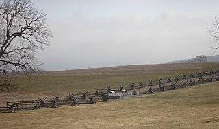
Antietam National Battlefield is a National Park Service-protected area along Antietam Creek in Sharpsburg, Washington County, northwestern Maryland. It commemorates the American Civil War Battle of Antietam that occurred on September 17, 1862.

National Capital Parks-East (NACE) is an administrative grouping of multiple National Park Service sites east of the United States Capitol in Washington, D.C., and in the state of Maryland. These sites include:

Waterrock Knob

Waterrock Knob is a mountain peak in the U.S. state of North Carolina. It is the highest peak in the Plott Balsams and is the 16th-highest mountain in the Eastern United States.

The Chesapeake Bay Gateways Network is a partnership program of the National Park Service and a system of over 150 parks, refuges, museums, historic communities and water trails in the Chesapeake Bay watershed. As a partnership program, it is not considered a Unit of the National Park System. Sites in the greater Chesapeake Bay Watershed are eligible to participate in the Network, including sites in the Potomac River basin out to West Virginia and sites in the Susquehanna River basin out to New York State. The Network is managed by the National Park Service's Chesapeake Bay Office in Annapolis, Maryland, which also manages the Captain John Smith Chesapeake National Historic Trail and the Star-Spangled Banner National Historic Trail

South Mountain State Park State park in Maryland, United States

South Mountain State Park is a public recreation area that runs for nearly the entire length of South Mountain through Washington and Frederick counties in Maryland. The state park is contiguous with several other national, state and local parks on the mountain, including the Chesapeake and Ohio Canal National Historical Park, Gathland State Park, Washington Monument State Park, Greenbrier State Park and Pen Mar County Park.

Hagerstown, Maryland City in Maryland, United States

HagerstownHAY-gərz-town is a city in Washington County, Maryland, United States and the county seat of Washington County. The population of Hagerstown city proper at the 2010 census was 39,662, and the population of the Hagerstown metropolitan area was 269,140. Hagerstown ranks as Maryland's sixth-largest incorporated city and is the largest city in the Panhandle.

Environment of Virginia

The natural environment of Virginia encompasses the physical geography and biology of the U.S. state of Virginia. Virginia has a total area of 42,774.2 square miles (110,784.67 km2), including 3,180.13 square miles (8,236.5 km2) of water, making it the 35th-largest state by area. Forests cover 65% of the state, wetlands and water cover 6% of the land in the state, while 5% of the state is a mixture of commercial, residential, and transitional.

Oxon Run Parkway

The Oxon Run Parkway is a corridor of federal park land in the Washington Highlands neighborhood of Washington, D.C. The Parkway once extended across the District's southern corner in a crescent from Hillcrest Heights to Oxon Hill but most of it became Oxon Run Park in 1971, and now only the portion north of 13th Street still uses the Parkway name. It was originally intended to provide recreation space, but was later enlarged to provide flood relief, space for a major piece of sewer infrastructure and the possibility of a clean drinking water source.

Gettysburg Museum and Visitor Center

The Gettysburg Museum and Visitor Center is a Gettysburg National Military Park facility, with a museum about the American Civil War, the 1884 Gettysburg Cyclorama, and the tour center for licensed Battlefield Guides and for buses to see the Gettysburg Battlefield and Eisenhower National Historic Site.

Oxon Run Stream in Maryland, USA

Oxon Run is a tributary stream of Oxon Creek and the Potomac River in Prince George's County, Maryland, and Washington, D.C.

References

  1. 1 2 Tilberg, Frederick (1960). "Antietam National Battlefield Site and Cemetery". Antietam National Battlefield Site Maryland Historical Handbook. National Park Service. Retrieved 2008-02-08.
  2. "1930 through 1939". National Park System Timeline. National Park Service. Archived from the original on 2008-02-10. Retrieved 2007-07-10.
  3. "Appalachian National Scenic Trail". National Park Service. Retrieved 2008-02-15.
  4. "History". Appalachian Trail Conservancy. Archived from the original on 2007-06-07. Retrieved 2007-07-10.
  5. "Experience Your Park". National Park Service. Retrieved 2008-02-15.
  6. 1 2 3 4 5 6 7 8 9 10 11 12 13 14 "National Park System Timeline". National Park Service. Retrieved 2007-07-10.
  7. 1 2 "Baltimore-Washington Parkway". National Park Service. Retrieved 2008-02-14.
  8. 1 2 "Captain John Smith Management". National Park Service. Retrieved 2007-07-10.
  9. "Catoctin Mountain Park - Nature & Science". National Park Service. Retrieved 2008-02-16.
  10. "Chesapeake & Ohio Canal National Historical Park - Nature & Science". National Park Service. Retrieved 2008-02-16.
  11. 1 2 "Sarbanes and Mikulski Announce New Chesapeake Bay Gateway Network Sites". Office of U.S. Senator Barbara Mikulski. Archived from the original on 2007-06-27. Retrieved 2007-07-10.
  12. "The Clara Barton House". National Park Service. Retrieved 2007-07-10.
  13. "Fort Foote Park: History & Culture". National Park Service. Retrieved 2007-07-10.
  14. "About Glen Echo Park". Glen Echo Park Partnership for Arts and Culture, Inc. Archived from the original on 2007-07-29. Retrieved 2007-07-10.
  15. "Greenbelt Park". MSN Encarta. Archived from the original on 2009-11-01. Retrieved 2008-02-18.
  16. "Harmony Hall". National Park Service. Retrieved 2008-02-16.
  17. "Harmony Hall". Pack Your Gear.com. Archived from the original on 2007-09-29. Retrieved 2007-07-10.
  18. "Oxon Cove Park and Oxon Hill Farm: History & Culture". National Park Service. Retrieved 2008-02-17.
  19. "Oxon Cove Park and Oxon Hill Farm: History & Culture". National Park Service. Retrieved 2007-07-10.
  20. "Fort Foote Park". National Park Service. Retrieved 2008-02-14.
  21. "Harmony Hall". National Park Service. Retrieved 2008-02-14.
  22. "National Capital Parks-East". National Park Service. Retrieved 2008-02-14.
  23. "Suitland Parkway". National Park Service. Retrieved 2008-02-14.