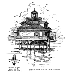
A screw-pile lighthouse is a lighthouse which stands on piles that are screwed into sandy or muddy sea or river bottoms. The first screw-pile lighthouse to begin construction was built by the blind Irish engineer Alexander Mitchell. Construction began in 1838 at the mouth of the Thames and was known as the Maplin Sands lighthouse, and first lit in 1841. However, though its construction began later, the Wyre Light in Fleetwood, Lancashire, was the first to be lit.

Makapuʻu is the extreme eastern end of the Island of Oʻahu in the Hawaiian Islands, comprising the remnant of a ridge that rises 647 feet (197 m) above the sea. The cliff at Makapuʻu Point forms the eastern tip and is the site of a prominent lighthouse. The place name of this area, meaning "bulging eye" in Hawaiian, is thought to derive from the name of an image said to have been located in a cave here called Keanaokeakuapōloli. The entire area is quite scenic and a panoramic view is presented at the lookout on Kalanianaole Highway where the roadway surmounts the cliff just before turning south towards leeward Oʻahu and Honolulu.
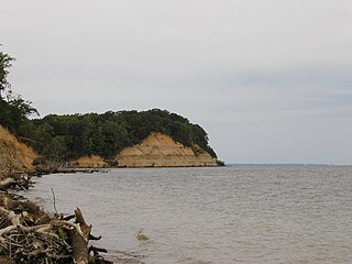
Calvert Cliffs State Park is a public recreation area in Lusby, Calvert County, Maryland, that protects a portion of cliffs that extend for 24 miles along the eastern flank of the Calvert Peninsula on the west side of Chesapeake Bay from Chesapeake Beach southward to Drum Point. The state park is known for the abundance of mainly Middle Miocene sub-epoch fossils that can be found on the shoreline.

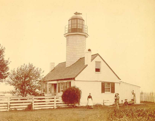
Point Lookout State Park is a public recreation area and historic preserve occupying Point Lookout, the southernmost tip of a peninsula formed by the confluence of Chesapeake Bay and the Potomac River in St. Mary's County, Maryland. The state park preserves the site of an American Civil War prisoner of war camp and the Point Lookout Light, which was built in 1830. It is the southernmost spot on Maryland's western shore, the coastal region on the western side of the Chesapeake Bay.

The Thomas Point Shoal Light, also known as Thomas Point Shoal Light Station, is a historic lighthouse in the Chesapeake Bay on the east coast of the United States, and the most recognized lighthouse in Maryland. It is the only screw-pile lighthouse in the bay which stands at its original site. The current structure is a 1½ story hexagonal wooden cottage, equipped with a foghorn as well as the light.

Wilderness State Park is a public recreation area bordering Lake Michigan, five miles southwest of Mackinaw City in Emmet County in Northern Michigan. The state park's 10,512 acres (4,254 ha) include 26 miles (42 km) of shoreline, diverse forested dune and swale complexes, wetlands, camping areas, and many miles of hiking trails. The state park is operated by the Michigan Department of Natural Resources, which has, as of 2006, approved a proposal that 4,492 acres (1,818 ha) be officially dedicated as a wilderness area. Wilderness State Park was designated a Michigan "dark sky preserve" in 2012.

Cheboygan State Park is a public recreation area covering 1,250 acres (510 ha) on the shores of Lake Huron in Cheboygan County, Michigan, United States. The state park offers views of the Fourteen Foot Shoal Light and the remains of the 1859 Cheboygan Point Light plus a distant view of the Poe Reef Light, some six miles to the northeast.
Orchard Beach State Park is a public recreation area covering 201 acres (81 ha) on the shore of Lake Michigan in Manistee Township, Manistee County, Michigan. Situated on a bluff three miles north of the city of Manistee, the state park offers a beach, campground, and hiking trails.
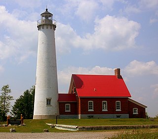
Tawas Point State Park is a public recreation area located on Lake Huron in Northern Michigan near the city of East Tawas, Michigan. The state park encompasses 183 acres (74 ha) at the end of a sand spit that forms Tawas Bay. It has been referred to as the "Cape Cod of the Midwest" and is a notable bird-watching site. The park is home to the Tawas Point Light, which, although it has been remodeled several times, serves as the sole representative of a true Victorian-era style station built on the Great Lakes.
The South River is a 10-mile-long (16 km) tributary of the Chesapeake Bay in Anne Arundel County, Maryland in the United States. It lies south of the Severn River, east of the Patuxent River, and north of the West River and Rhode River, and drains to the Chesapeake Bay.

The East Coast Trail (ECT) is a long-distance coastal footpath located in the Canadian province of Newfoundland and Labrador. It is a developed trail over 300 kilometres (190 mi) long, creation of which began in 1994. It is made up of 26 linked wilderness paths and passes through more than 30 communities. It was named one of the best adventure destinations by National Geographic in 2012 and is extended and improved yearly.

Peninsula State Park is a 3,776-acre (1,528 ha) Wisconsin state park with eight miles (13 km) of Green Bay shoreline in Door County. Peninsula is the third largest state park in Wisconsin, and is visited by an estimated one million visitors annually.

Sandy Point Shoal Light is a brick three story lighthouse on a caisson foundation that was erected in 1883. It lies about 0.6 mi (0.97 km) off Sandy Point, north of the Chesapeake Bay Bridge, from whose westbound span it is readily visible.
Greenbury Point Light was the name of two lighthouses in the Chesapeake Bay, both located at the mouth of the Severn River in Annapolis, Maryland.

Elk Neck State Park is a public recreation area located between Chesapeake Bay and the Elk River near the southern tip of the Elk Neck Peninsula in Cecil County, Maryland. The state park is home to the historic Turkey Point Light and offers land-based and water-based recreation. The park is located on MD 272, eight miles (13 km) south of the town of North East, and 13 miles (21 km) south of exit 100 on I-95. It is operated by the Maryland Department of Natural Resources.

Matapeake State Park is a public recreation area on Chesapeake Bay occupying the site of a former ferry landing in Matapeake, Kent Island, Maryland. The landing served the state-owned Chesapeake Bay Ferry System before the Chesapeake Bay Bridge opened. The park is leased and managed by Queen Anne's County.

A polar bear plunge is an event held during the winter where participants enter a body of water despite the low temperature. In the United States, polar bear plunges are usually held to raise money for a charitable organization. In Canada, polar bear swims are usually held on New Year's Day to celebrate the new year.
North Point State Park is a public recreation area located on Chesapeake Bay in Edgemere, Baltimore County, Maryland. The state park includes the site of the former Bay Shore Park, which was one of the state's premiere amusement parks during the first half of the 20th century. The park features restored remnants of the old amusement park as well as facilities for swimming, picnicking, bicycling, and hiking. Black Marsh, a 667-acre (270 ha) state wildlands area, makes up half the park's area. The park is administered by the Maryland Department of Natural Resources.

Hart-Miller Island State Park is a state-owned, public recreation area located on Hart-Miller Island, a man-made landfill linking three natural Chesapeake Bay islands—Hart, Miller, and Pleasure—near the mouth of Middle River in Maryland. The state park is accessible only by boat.

Janes Island State Park is a public recreation area on Chesapeake Bay lying adjacent to the city of Crisfield in Somerset County, Maryland. The state park features some 30 miles (48 km) of marked water trails through the island's salt marsh leading to isolated pristine beaches. The park is managed by the Maryland Department of Natural Resources.

