Millington, Maryland

Last updated

Millington, Maryland
Flag of Millington, Maryland.png
Seal of Millington, Maryland.png
Kent County Maryland Incorporated and Unincorporated areas Millington Highlighted.svg
Location of Millington, Maryland
Coordinates: 39°15′34″N75°50′19″W / 39.25944°N 75.83861°W / 39.25944; -75.83861
Country United States
State Maryland
Counties Kent, Queen Anne's
Incorporated 1890 [1]
Area
[2]
  Total0.74 sq mi (1.92 km2)
  Land0.72 sq mi (1.85 km2)
  Water0.02 sq mi (0.06 km2)
Elevation
20 ft (6 m)
Population
 (2020)
  Total549
  Density766.76/sq mi (295.98/km2)
Time zone UTC-5 (Eastern (EST))
  Summer (DST) UTC-4 (EDT)
ZIP code
21651
Area code 410 443
FIPS code 24-52825
GNIS feature ID0585893
Website millingtonmd.us

Millington is a town in Kent and Queen Anne's counties in the U.S. state of Maryland. The population was 642 at the 2010 census. Millington is the head of navigation for the Chester River.

Contents

History

The John Embert Farm was listed on the National Register of Historic Places in 1980. [3]

Geography

Millington is located at 39°15′34″N75°50′19″W / 39.25944°N 75.83861°W / 39.25944; -75.83861 (39.259355, -75.838666). [4]

According to the United States Census Bureau, the town has a total area of 0.69 square miles (1.79 km2), of which 0.67 square miles (1.74 km2) is land and 0.02 square miles (0.05 km2) is water. [5]

MD 291 westbound in Millington 2022-06-30 11 45 09 View west along Maryland State Route 291 (Cypress Street) at Comegys Street in Millington, Kent County, Maryland.jpg
MD 291 westbound in Millington

Transportation

The primary means of transportation to and from Millington is by road, and the town is served by two state highways. Maryland Route 291 traverses the town east-west, while Maryland Route 313 heads north and south from Millington. Both roads connect with U.S. Route 301 to the northwest, providing high-speed access to nearby metropolitan areas such as Philadelphia and Washington D.C.

Climate

The climate in this area is characterized by hot, humid summers and generally mild to cool winters. According to the Köppen Climate Classification system, Millington has a humid subtropical climate, abbreviated "Cfa" on climate maps. [6]

Demographics

Historical population
CensusPop.Note
1860 306
1870 42037.3%
1880 4445.7%
1890 4859.2%
1900 406−16.3%
1910 399−1.7%
1920 368−7.8%
1930 3710.8%
1940 307−17.3%
1950 35616.0%
1960 40814.6%
1970 47416.2%
1980 54615.2%
1990 409−25.1%
2000 4161.7%
2010 64254.3%
2020 549−14.5%
U.S. Decennial Census [7]

2010 census

As of the census [8] of 2010, there were 642 people, 234 households, and 174 families living in the town. The population density was 958.2 inhabitants per square mile (370.0/km2). There were 256 housing units at an average density of 382.1 per square mile (147.5/km2). The racial makeup of the town was 72.0% White, 13.9% African American, 3.0% Asian, 9.3% from other races, and 1.9% from two or more races. Hispanic or Latino of any race were 13.9% of the population.

There were 234 households, of which 37.2% had children under the age of 18 living with them, 50.4% were married couples living together, 17.1% had a female householder with no husband present, 6.8% had a male householder with no wife present, and 25.6% were non-families. 17.1% of all households were made up of individuals, and 4.7% had someone living alone who was 65 years of age or older. The average household size was 2.74 and the average family size was 2.95.

The median age in the town was 36.2 years. 22.6% of residents were under the age of 18; 11.5% were between the ages of 18 and 24; 29.2% were from 25 to 44; 27.8% were from 45 to 64; and 9% were 65 years of age or older. The gender makeup of the town was 48.6% male and 51.4% female.

2000 census

As of the census [9] of 2000, there were 416 people, 163 households, and 106 families living in the town. The population density was 1,294.7 inhabitants per square mile (499.9/km2). There were 173 housing units at an average density of 538.4 per square mile (207.9/km2). The racial makeup of the town was 87.02% White, 6.49% African American, 4.33% from other races, and 2.16% from two or more races. Hispanic or Latino of any race were 7.69% of the population.

There were 163 households, out of which 31.9% had children under the age of 18 living with them, 49.7% were married couples living together, 9.8% had a female householder with no husband present, and 34.4% were non-families. 28.2% of all households were made up of individuals, and 13.5% had someone living alone who was 65 years of age or older. The average household size was 2.55 and the average family size was 3.07.

In the town, the population was spread out, with 26.0% under the age of 18, 7.2% from 18 to 24, 29.8% from 25 to 44, 21.4% from 45 to 64, and 15.6% who were 65 years of age or older. The median age was 37 years. For every 100 females, there were 91.7 males. For every 100 females age 18 and over, there were 100.0 males.

The median income for a household in the town was $45,893, and the median income for a family was $48,750. Males had a median income of $29,917 versus $28,500 for females. The per capita income for the town was $20,240. About 8.6% of families and 12.9% of the population were below the poverty line, including 23.1% of those under age 18 and none of those age 65 or over.

Education

It is in the Kent County Public Schools. Kent County Middle School is in Chestertown, and Kent County High School is in an unincorporated area, in the Butlertown CDP with a Worton postal address.

In 2017 the school board voted to close Millington Elementary School. [10] In 2019 there were discussions about possibly reopening Millington Elementary. [11]

Related Research Articles

<span class="mw-page-title-main">Kent County, Maryland</span> County in Maryland, United States

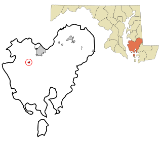
Kent County is a county located in the U.S. state of Maryland. As of the 2020 census, its population was 19,198, making it the least populous county in Maryland. Its county seat is Chestertown. The county was named for the county of Kent in England.

<span class="mw-page-title-main">Queen Anne's County, Maryland</span> County in Maryland, United States

Queen Anne's County is located on the Eastern Shore of the U.S. state of Maryland. As of the 2020 census, the population was 49,874. Its county seat and most populous municipality is Centreville. The census-designated place of Stevensville is the county's most populous place with population of 7,442 as of 2020. The county is named for Queen Anne of Great Britain, who reigned when the county was established in 1706 during the colonial period.

<span class="mw-page-title-main">Kent County, Delaware</span> County in Delaware, United States

Kent County is a county located in the central part of the U.S. state of Delaware. As of the 2020 census, the population was 181,851, making it the least populous county in Delaware. The county seat is Dover, the state capital of Delaware. It is named for Kent, an English county.

<span class="mw-page-title-main">Calhoun, Kentucky</span> City in Kentucky, United States

Calhoun is a home rule-class city in McLean County, Kentucky, United States. The population was 725 at the 2020 census. It is the county seat of McLean County. It is included in the Owensboro, Kentucky Metropolitan Statistical Area.

<span class="mw-page-title-main">Veazie, Maine</span> Town in the state of Maine, United States

Veazie is a town in Penobscot County, Maine, United States. The population was 1,814 at the 2020 census. The town is named after General Samuel Veazie, an early lumber baron and railroad operator. Veazie was originally part of Bangor, using Penobscot River water power to operate sawmills. It became a separate town in 1853 because Gen. Veazie, its wealthiest citizen, thought Bangor's property taxes were too high.

<span class="mw-page-title-main">Westernport, Maryland</span> Town in Maryland, United States

Westernport is a town in Allegany County, Maryland, United States, along the Georges Creek Valley. It is part of the Cumberland, MD-WV Metropolitan Statistical Area. The population was 1,888 at the 2010 census.

<span class="mw-page-title-main">Preston, Maryland</span> Town in Maryland

Preston is a town in Caroline County, Maryland, United States. The population was 719 at the 2010 census.

<span class="mw-page-title-main">Church Creek, Maryland</span> Town in Maryland, United States

Church Creek is a town in Dorchester County, Maryland, United States, part of the state's Eastern Shore. The population was 125 at the 2010 census. Church Creek is located approximately six miles south of Cambridge.

<span class="mw-page-title-main">Betterton, Maryland</span> Historic district in Maryland, United States

Betterton is a town in Kent County, Maryland, United States. The population was 345 at the 2010 census.

<span class="mw-page-title-main">Chestertown, Maryland</span> Town in Maryland, United States

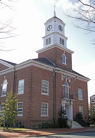
Chestertown is a town in Kent County, Maryland, United States. The population was 5,252 as of the 2010 census. It is the county seat of Kent County.

<span class="mw-page-title-main">Galena, Maryland</span> Town in Maryland, United States

Galena is a town in Kent County, Maryland, United States. The population was 612 at the 2010 census.

<span class="mw-page-title-main">Rock Hall, Maryland</span> Town in Maryland, United States

Rock Hall, is a waterfront town located directly on the National Chesapeake Scenic Byway in Kent County, Maryland, United States. The population was 1,310 at the 2010 census.

<span class="mw-page-title-main">Barnesville, Maryland</span> Town in Maryland, United States

Barnesville is a town in Montgomery County, Maryland, United States. It was incorporated in 1888. The population was 144 at the 2020 census.

<span class="mw-page-title-main">Princess Anne, Maryland</span> Town in Maryland, United States

Princess Anne is a town in Somerset County, Maryland, United States, that also serves as its county seat. Its population was 3,290 at the 2010 census. It is included in the Salisbury, Maryland–Delaware Metropolitan Statistical Area. It is home to the University of Maryland Eastern Shore and the Teackle Mansion.

<span class="mw-page-title-main">Mardela Springs, Maryland</span> Town in Maryland, United States

Mardela Springs is a town in Wicomico County, Maryland, United States. The population was 357 at the 2010 census. It is included in the Salisbury, Maryland-Delaware Metropolitan Statistical Area.

<span class="mw-page-title-main">Millington, Michigan</span> Village in Michigan, United States

Millington is a village in Tuscola County, Michigan, United States. The population was 1,072 at the 2010 census. The village is located within Millington Township.

<span class="mw-page-title-main">Jordan Township, Clearfield County, Pennsylvania</span> Township in Pennsylvania, United States

Jordan Township is a township in Clearfield County, Pennsylvania, United States. The population was 476 at the time of the 2020 census.

Northwest St. Louis is an unorganized territory in Saint Louis County, Minnesota, United States. The population was 306 at the 2000 census.

<span class="mw-page-title-main">Sherman, Mississippi</span> Town in Mississippi, United States

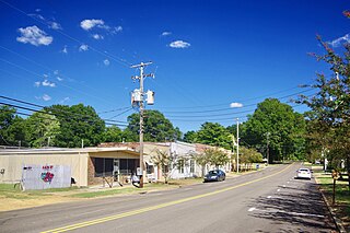
Sherman is a town which straddles Lee, Pontotoc, and Union counties in Mississippi. The population was 600 at the 2020 census.

<span class="mw-page-title-main">Dallas, Wisconsin</span> Village in Wisconsin, United States

Dallas is a village in Barron County in the U.S. state of Wisconsin. The population was 409 at the 2010 census. The village is located within the Town of Dallas.

References

  1. "Millington". Maryland Manual. Retrieved June 27, 2017.
  2. "2020 U.S. Gazetteer Files". United States Census Bureau. Retrieved April 26, 2022.
  3. "National Register Information System". National Register of Historic Places . National Park Service. July 9, 2010.
  4. "US Gazetteer files: 2010, 2000, and 1990". United States Census Bureau. February 12, 2011. Retrieved April 23, 2011.
  5. "US Gazetteer files 2010". United States Census Bureau. Archived from the original on July 2, 2012. Retrieved January 25, 2013.
  6. Climate Summary for Millington, Maryland
  7. "Census of Population and Housing". Census.gov. Retrieved June 4, 2015.
  8. "U.S. Census website". United States Census Bureau . Retrieved January 25, 2013.
  9. "U.S. Census website". United States Census Bureau . Retrieved January 31, 2008.
  10. Divilio, Daniel (March 21, 2017). "Millington, Worton elementary schools closing". Kent County News . Retrieved June 10, 2021.
  11. Divilio, Daniel (May 16, 2019). "Fithian seeks conversation about Millington school". Kent County News . Retrieved June 10, 2021. - Alternate title at Pressreader: "County seeks talks about Millington school"