Betterton, Maryland

Last updated

Betterton, Maryland
Flag of Betterton, Maryland.png
Seal of Betterton, Maryland.png
Kent County Maryland Incorporated and Unincorporated areas Betterton Highlighted.svg
Location of Betterton, Maryland
Coordinates: 39°22′4″N76°3′39″W / 39.36778°N 76.06083°W / 39.36778; -76.06083
Country Flag of the United States.svg United States
State Flag of Maryland.svg  Maryland
County Flag of Kent County, Maryland.gif Kent
Incorporated 1906 [1]
Government
  TypeMayor-Council
  MayorDonald E. Sutton
Area
[2]
  Total1.00 sq mi (2.58 km2)
  Land0.99 sq mi (2.56 km2)
  Water0.01 sq mi (0.02 km2)
Elevation
72 ft (22 m)
Population
 (2020)
  Total286
  Density288.89/sq mi (111.54/km2)
Time zone UTC-5 (Eastern (EST))
  Summer (DST) UTC-4 (EDT)
ZIP code
21610
Area code 410
FIPS code 24-07200
GNIS feature ID0583196
Website townofbetterton.com
Betterton Historic District
BETTERTON HISTORIC DISTRICT, KENT COUNTY MD.jpg
Rigbie Hotel
USA Maryland location map.svg
Red pog.svg
Usa edcp location map.svg
Red pog.svg
LocationRoughly bounded by Sassafras River, Gut Marsh, 6th, and Ericsson Aves., Betterton, Maryland
Coordinates 39°22′2″N76°3′47″W / 39.36722°N 76.06306°W / 39.36722; -76.06306
Built1880
Architectural styleGothic
NRHP reference No. 84001805 [3]
Added to NRHPJune 7, 1984

Betterton is a town in Kent County, Maryland, United States. The population was 345 at the 2010 census.

Contents

Geography

Betterton is located at the mouth of the Sassafras River on the upper Chesapeake Bay in Kent County, Maryland, on the Eastern Shore region of the Bay and Delmarva Peninsula in the Eastern United States). The GPS coordinates are 39°22′4″N76°3′39″W / 39.36778°N 76.06083°W / 39.36778; -76.06083 (39.367863, -76.060877). [4]

According to the United States Census Bureau, the town has a total area of 1.00 square mile (2.59 km2), of which 0.99 square miles (2.56 km2) is land and 0.01 square miles (0.03 km2) is water. [5]

Betterton Historic District

The Betterton Historic District consists of a collection of vernacular Victorian era-style wooden frame resort structures. The district includes many of the homes, hotels and cottages built to accommodate steamboat passengers in the late 19th and early 20th centuries. Notable buildings within the district include the hotels and boarding homes which catered to the steamboat passengers, several churches, and summer cottages, dating from the golden age of the passenger steamboats on the Chesapeake Bay. [6]

It was added to the National Register of Historic Places, (maintained by the National Park Service of the United States Department of the Interior) in 1984. [3]

History

The recorded history of Betterton dates back to the 17th century. The Fishall Patent was granted in 1664, later becoming known as Fish Hall. The house located at 104 Ericsson Avenue contains foundation bricks dating back to 1698. In 1715, Edward Crew leased Fish Hall and the name was changed to Crews Landing. For the next 100 years, Crews Landing was a small fishing village and then later a port for the waterborne transport of local farm produce to urban markets. In 1851, Richard Townsend Turner (a Quaker) named the town “Betterton” after the family of his wife Elizabeth Betterton. The Turner pier, and later the Ericsson pier, provided access to the town for the shipping trade. Eventually townspeople rented out rooms to the travelers, salesmen, and shippers attracted to the beach. Mr. Turner built the Rigbie Hotel (demolished in August 1986) and Mr. Crownhart built the Belmont Hotel (destroyed by fire in 1956). These were joined by such lodging establishments as the Betterton, the Chesapeake, the Country Cousin, the Southern, and many others.

Steamboat traffic from downtown Baltimore's "The Basin" (now Inner Harbor) and Philadelphia on the excursion cruises like the Old Bay Line (Baltimore Steam Packet Company, 1840-1962) and the competing Ericsson Line (and others, such as the Wilson Line later) brought the visitors and vacationers from the Middle Atlantic cities. The Ericsson Line was named after John Ericsson (1803-1889), the Swedish-American inventor of the "screw propeller" (and of Civil War revolutionary naval Ironclad warships) to more speedily and efficiently power ships. It was this invention that allowed steamboats to be built with narrow enough beam to allow them to traverse the recently opened Chesapeake and Delaware Canal then only 25 feet wide (before it was later widened and improved), connecting the upper Chesapeake with the Delaware River and Bay. Betterton was an easy and natural stop for boats using the canal and the explosion in steamboat traffic along the American East Coast brought growth and prosperity to Betterton. For some time before the turn of the 20th century, there were 11 scheduled steamboat landings daily at Betterton's piers. The boom period for Betterton is generally thought to be from 1918 to 1930, when increasing numbers of restaurants, taverns, dance halls, bowling alleys, and amusement arcades all helped create the bayside town's pleasure resort image.

It eventually declined along with neighboring competing Tolchester and Tolchester Beach after the 1949-1952 construction of the Chesapeake Bay Bridge from Annapolis to Kent Island and increasing automobile traffic over improved U.S. Routes and Interstate Highways systems in following decades to North Atlantic Ocean beaches and growing resort towns there like Ocean City, Maryland and Rehoboth Beach, Delaware [7]

Government

Betterton is governed by a mayor and a town council with four members. Town council meetings are held on the second and fourth Tuesday of every month at 7:00 pm in the town hall. The town hall is located in the Betterton Community Center, a former Catholic church refurbished as town offices and a museum, on Main Street.

View south at the north end of MD 292 in Betterton 2022-06-30 16 08 06 View south at the north end of Maryland State Route 292 (Main Street) at Ericsson Avenue in Betterton, Kent County, Maryland.jpg
View south at the north end of MD 292 in Betterton

Transportation

The primary means of travel to and from Betterton is by road. The only state highway serving the town is Maryland Route 292, which has its northern terminus at the north end of town.

Betterton Beach

Betterton Beach is located at the foot of Main Street. The beach has 300 feet (91 m) of frontage for swimming. The water is generally free of sea nettles because the water is not very salty. The beach has public restrooms (seasonal), a boardwalk, a fishing jetty, a public landing, and reasonable parking. A picnic pavilion is nearby. [8]

Demographics

Historical population
CensusPop.Note
1910 308
1920 3276.2%
1930 296−9.5%
1940 221−25.3%
1950 31442.1%
1960 3284.5%
1970 327−0.3%
1980 3568.9%
1990 3601.1%
2000 3764.4%
2010 345−8.2%
2020 286−17.1%
U.S. Decennial Census [9]

2010 census

As of the census [10] of 2010, there were 345 people, 156 households, and 88 families residing in the town. The population density was 348.5 inhabitants per square mile (134.6/km2). There were 317 housing units at an average density of 320.2 per square mile (123.6/km2). The racial makeup of the town was 92.5% White, 2.9% African American, 0.9% Native American, 0.6% Asian, 1.7% from other races, and 1.4% from two or more races. Hispanic or Latino of any race were 2.9% of the population.

There were 156 households, of which 23.7% had children under the age of 18 living with them, 41.0% were married couples living together, 8.3% had a female householder with no husband present, 7.1% had a male householder with no wife present, and 43.6% were non-families. 36.5% of all households were made up of individuals, and 10.2% had someone living alone who was 65 years of age or older. The average household size was 2.21 and the average family size was 2.94.

The median age in the town was 46.9 years. 18.6% of residents were under the age of 18; 8.4% were between the ages of 18 and 24; 20.3% were from 25 to 44; 36.7% were from 45 to 64; and 15.9% were 65 years of age or older. The gender makeup of the town was 49.3% male and 50.7% female.

2000 census

As of the census [11] of 2000, there were 376 people, 164 households, and 102 families residing in the town. The population density was 423.9 inhabitants per square mile (163.7/km2). There were 277 housing units at an average density of 312.3 per square mile (120.6/km2). The racial makeup of the town was 92.29% White, 2.13% African American, 4.52% from other races, and 1.06% from two or more races. Hispanic or Latino of any race were 8.24% of the population.

There were 164 households, out of which 29.3% had children under the age of 18 living with them, 47.0% were married couples living together, 11.6% had a female householder with no husband present, and 37.8% were non-families. 34.1% of all households were made up of individuals, and 11.6% had someone living alone who was 65 years of age or older. The average household size was 2.29 and the average family size was 2.94.

In the town, the population was spread out, with 26.1% under the age of 18, 8.8% from 18 to 24, 25.8% from 25 to 44, 25.8% from 45 to 64, and 13.6% who were 65 years of age or older. The median age was 39 years. For every 100 females, there were 88.9 males. For every 100 females age 18 and over, there were 86.6 males.

The median income for a household in the town was $36,477, and the median income for a family was $38,750. Males had a median income of $31,250 versus $27,188 for females. The per capita income for the town was $24,848. About 6.1% of families and 6.8% of the population were below the poverty line, including 9.5% of those under age 18 and 9.5% of those age 65 or over.

Education

It is in the Kent County Public Schools. Kent County Middle School is in Chestertown, and Kent County High School is in an unincorporated area, in the Butlertown census-designated place with a Worton postal address.

The community was formerly assigned to Worton Elementary School. [12] In 2017 the school board voted to close Worton Elementary. [13]

Related Research Articles

<span class="mw-page-title-main">Kent County, Maryland</span> County in Maryland, United States

Kent County is a county located in the U.S. state of Maryland. As of the 2020 census, its population was 19,198, making it the least populous county in Maryland. Its county seat is Chestertown. The county was named for the county of Kent in England.

<span class="mw-page-title-main">Queen Anne's County, Maryland</span> County in Maryland, United States

Queen Anne's County is located on the Eastern Shore of the U.S. state of Maryland. As of the 2020 census, the population was 49,874. Its county seat and most populous municipality is Centreville. The census-designated place of Stevensville is the county's most populous place with population of 7,442 as of 2020. The county is named for Queen Anne of Great Britain, who reigned when the county was established in 1706 during the colonial period.

<span class="mw-page-title-main">Bowers, Delaware</span> Town in Delaware, United States

Bowers is a town in Kent County, Delaware, United States. It is part of the Dover, Delaware Metropolitan Statistical Area. According to the 2020 census, its population was 278.

<span class="mw-page-title-main">Felton, Delaware</span> Town in Delaware, United States

Felton is a town in Kent County, Delaware, United States. It is part of the Dover metropolitan statistical area. The population was 1,568 in 2020.

<span class="mw-page-title-main">Hartly, Delaware</span> Town in Delaware, United States

Hartly is a town in Kent County, Delaware, United States. It is part of the Dover, Delaware Metropolitan Statistical Area. The population was 73 in 2020, making it the least populous municipality in Delaware.

<span class="mw-page-title-main">Fenwick Island, Delaware</span> Town in Delaware, United States

Fenwick Island is a coastal resort town in Sussex County, Delaware, United States. According to 2020 census figures, the population of the town is 355, a 2.6% decrease over the last decade. It is part of the Salisbury, Maryland–Delaware Metropolitan Statistical Area. The town is located on Fenwick Island, a barrier spit.

<span class="mw-page-title-main">Highland Beach, Maryland</span> Town in Maryland, United States

Highland Beach is a town in Anne Arundel County, Maryland, United States. Per the 2020 census, the population was 118. The town was founded late in the 19th century by affluent African Americans from Washington, D.C., and Baltimore, looking for a summer retreat on the Chesapeake Bay. The town's incorporated status gave it a unique standing in empowering it to maintain its own police force. Celebrities with homes there have included historian and author Alex Haley, actor and comedian Bill Cosby, and tennis champion Arthur Ashe. Street names in the town include Crummell, Dunbar, Henson, Augusta, Douglass, Langston, and Washington, which were chosen to honor leading African Americans.

<span class="mw-page-title-main">Lake Shore, Maryland</span> Census-designated place in Maryland, United States

Lake Shore is a census-designated place and unincorporated community in Anne Arundel County, Maryland, United States, located east of Pasadena. The population of Lake Shore was 19,477 at the 2010 census.

<span class="mw-page-title-main">Pasadena, Maryland</span> Census-designated place in Maryland, United States

Pasadena is a census-designated place (CDP) in Anne Arundel County, Maryland, United States. The population was 24,287 at the 2010 census.

<span class="mw-page-title-main">Essex, Maryland</span> Census-designated place in Maryland, United States

Essex is an unincorporated community and census-designated place in Baltimore County, Maryland, United States. Essex history dates back to 1909. The population was 40,505 in the 2020 census, up from 39,262 in the 2010 census.

<span class="mw-page-title-main">Chesapeake Beach, Maryland</span> Town in Maryland

Chesapeake Beach is a town in Calvert County, Maryland, United States. Its major attractions include the Chesapeake Beach Railway Station, the Chesapeake Beach Rail Trail, a water park, marinas, piers, and charter boat fishing. The town's population was recorded as 5,753 in the 2010 census.

<span class="mw-page-title-main">North Beach, Maryland</span> Town in Maryland

North Beach is a town in Calvert County, Maryland, United States. The population was 1,978 at the 2010 U.S. Census.

<span class="mw-page-title-main">Owings, Maryland</span> Census-designated place in Maryland, United States

Owings is a town center and census-designated place (CDP) in northern Calvert County, Maryland, United States. The population was 2,149 at the 2010 census, up from 1,325 in 2000.

<span class="mw-page-title-main">Denton, Maryland</span> Town in Maryland

Denton is a town in Caroline County, Maryland, United States. The population of Denton was 4,418 as of the 2010 United States Census, and it is the county seat of Caroline County.

<span class="mw-page-title-main">Chesapeake City, Maryland</span> Town in Maryland, United States

Chesapeake City is a town in Cecil County, Maryland, United States. The population was 736 at the 2020 census.

<span class="mw-page-title-main">Galena, Maryland</span> Town in Maryland, United States

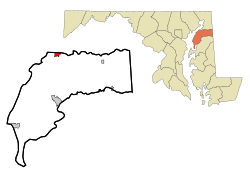
Galena is a town in Kent County, Maryland, United States. The population was 612 at the 2010 census.

<span class="mw-page-title-main">Rock Hall, Maryland</span> Town in Maryland, United States

Rock Hall, is a waterfront town located directly on the National Chesapeake Scenic Byway in Kent County, Maryland, United States. The population was 1,310 at the 2010 census.

<span class="mw-page-title-main">Leonardtown, Maryland</span> Town in Maryland, United States

Leonardtown is a town in and the county seat of St. Mary's County, Maryland, United States. The population was 4,563 at the 2020 census.

<span class="mw-page-title-main">Irvington, Virginia</span> Town in Virginia, United States

Irvington is a town on the Rappahannock River in Lancaster County, Virginia, United States. The population was 432 at the 2010 census. Located on a peninsula known as the Northern Neck, it has been designated a historic district.

<span class="mw-page-title-main">Millington, Maryland</span> Town in Maryland, United States

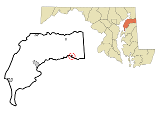
Millington is a town in Kent and Queen Anne's counties in the U.S. state of Maryland. The population was 642 at the 2010 census. Millington is the head of navigation for the Chester River.

References

  1. "Betterton". Maryland Manual. Retrieved June 26, 2017.
  2. "2020 U.S. Gazetteer Files". United States Census Bureau. Retrieved April 26, 2022.
  3. 1 2 "National Register Information System". National Register of Historic Places . National Park Service. April 15, 2008.
  4. "US Gazetteer files: 2010, 2000, and 1990". United States Census Bureau. February 12, 2011. Retrieved April 23, 2011.
  5. "US Gazetteer files 2010". United States Census Bureau. Archived from the original on July 2, 2012. Retrieved January 25, 2013.
  6. Maryland Historical Trust: Listing for Betterton Historic District
  7. "Town of Betterton – Jewel of the Chesapeake".
  8. "Local in Kent, Maryland". July 30, 2018.
  9. "Census of Population and Housing". Census.gov. Retrieved June 4, 2015.
  10. "U.S. Census website". United States Census Bureau . Retrieved January 25, 2013.
  11. "U.S. Census website". United States Census Bureau . Retrieved January 31, 2008.
  12. "Welcome to our school!". Worton Elementary School. October 2, 2006. Archived from the original on October 2, 2006. Retrieved June 10, 2021.
  13. "Board of Education Action and Written Decision to Close Millington Elementary School and Worton Elementary School" (PDF). Kent County Public Schools. March 22, 2017. Retrieved June 10, 2021.