
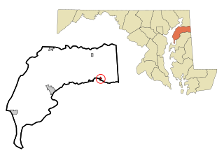
Kent County is a county located in the U.S. state of Maryland. As of the 2010 census, its population was 20,197, making it the least populous county in Maryland. Its county seat is Chestertown. The county was named for the county of Kent in England. The county is located on Maryland's Eastern Shore. It is one of three counties in Maryland, along with Caroline and Garrett, that is not part of a Metropolitan Statistical Area.

Betterton is a town in Kent County, Maryland, United States. The population was 345 at the 2010 census.

Chestertown is a town in Kent County, Maryland, United States. The population was 5,252 as of the 2010 census. It is the county seat of Kent County.

Galena is a town in Kent County, Maryland, United States. The population was 612 at the 2010 census.

Rock Hall, "The Pearl of the Chesapeake", is a waterfront town located directly on the National Chesapeake Scenic Byway in Kent County, Maryland, United States. It is located less than two hours away from large metropolitan areas such as Philadelphia, Baltimore and Washington, D.C. The population was 1,310 at the 2010 census.
Millington is a town in Kent and Queen Anne's counties in the U.S. state of Maryland. The population was 642 at the 2010 census. Millington is the head of navigation for the Chester River.
Millington is an unincorporated community located within Long Hill Township in Morris County, New Jersey, United States.

Abingdon is a census-designated place in Harford County, Maryland, United States. It lies 25 miles northeast of Baltimore on Maryland Route 7, near the Bush River, between Exits 77 and 80 of Interstate 95.
Still Pond is a census-designated place in Kent County, Maryland, United States. Still Pond is located at the intersection of Maryland routes 292 and 566 on Still Pond Neck, south-southeast of Betterton and north of Chestertown. Much of the community is included in the Still Pond Historic District and it is notable as the first place in Maryland in which women gained the right to vote.
Worton is an unincorporated community and census-designated place (CDP) in Kent County, Maryland, United States. As of the 2010 census it had a population of 249.
Kennedyville is an unincorporated community and census-designated place in Kent County, Maryland, United States. As of the 2010 census it had a population of 199.

Chesterville is an unincorporated community in Kent County, Maryland, United States. It is located at the intersection of Maryland routes 290 and Maryland Route 447|447.

Sassafras is an unincorporated community in Kent County, Maryland, United States. The Lanthim House, built in the 1720s, served as a general store.
Golts is an unincorporated community in Kent County, Maryland, United States. Golts is located at the intersection of Delaware Line Road and Black Bottom Road, east of Galena and west of the Delaware border.
Lynch is an unincorporated community in Kent County, Maryland, United States. Lynch is located along Maryland Route 561 at the crossing of the Maryland and Delaware Railroad, north of Chestertown.
Massey is an unincorporated community in Kent County, Maryland, United States. Massey is located at the intersection of Maryland routes 299, 313 and 330, southeast of Galena.

Croom is an unincorporated community and census-designated place in Prince George's County, Maryland, United States. As of the 2010 census it had a population of 2,631. Croom largely consists of former tobacco farms and forests converted to Washington bedroom subdivisions such as nearby Marlton. The main part of Patuxent River Park is in Croom.
Bristol is an unincorporated community in Anne Arundel County, Maryland, United States. Jug Bay Wetlands Sanctuary and the colonial town of Pig Point are on the Patuxent River waterfront portion of Bristol. Pig Point saw War of 1812 action and was the county's largest steamboat port on the Patuxent in the mid-19th century. Pig Point is a very significant Native American Early Archaic Period archaeological site.
Butlertown is an unincorporated community and census-designated place in Kent County, Maryland, United States. Its population was 505 as of the 2010 census.
Kent County Public Schools (KCPS) is a school district headquartered in Rock Hall, Maryland. It operates public schools in Kent County.


