
Kent County is a county located in the U.S. state of Maryland. As of the 2020 census, its population was 19,198, making it the least populous county in Maryland. Its county seat is Chestertown. The county was named for the county of Kent in England.

Betterton is a town in Kent County, Maryland, United States. The population was 345 at the 2010 census.

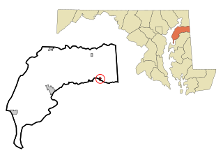
Chestertown is a town in Kent County, Maryland. The population was 5,252 as of the 2010 census. It is the county seat of Kent County.

Galena is a town in Kent County, Maryland, United States. The population was 612 at the 2010 census.

Rock Hall, is a waterfront town located directly on the National Chesapeake Scenic Byway in Kent County, Maryland, United States. The population was 1,310 at the 2010 census.
Millington is a town in Kent and Queen Anne's counties in the U.S. state of Maryland. The population was 642 at the 2010 census. Millington is the head of navigation for the Chester River.
Lanham is an unincorporated community and census-designated place in Prince George's County, Maryland. As of the 2020 United States Census it had a population of 11,282. The New Carrollton station as well as an Amtrak station are across the Capital Beltway in New Carrollton, Maryland. Doctors Community Hospital is located in Lanham.
Georgetown is an unincorporated community in northeastern Kent County, Maryland, United States. The community was laid out in 1736. Georgetown was named for Prince George who later became King of the United Kingdom. Georgetown is located on the south side of the Sassafras River at the Maryland Route 213 bridge, north of Galena and south of Cecilton. Directly to the north across the river is the unincorporated community of Fredericktown in Cecil County.
Pylesville is an unincorporated community and census-designated place (CDP) in Harford County, Maryland, United States. The population was 693 at the 2010 census. It is part of the Baltimore metropolitan area. Legend says the town was named after Brandon Pyles. Until 1958, this community was served by the Maryland and Pennsylvania Railroad at milepost 40.3.
Still Pond is a census-designated place in Kent County, Maryland, United States. Still Pond is located at the intersection of Maryland routes 292 and 566 on Still Pond Neck, south-southeast of Betterton and north of Chestertown. Much of the community is included in the Still Pond Historic District and it is notable as the first place in Maryland in which women gained the right to vote.
Worton is an unincorporated community and census-designated place (CDP) in Kent County, Maryland, United States. As of the 2010 census it had a population of 249.

Chesterville is an unincorporated community in Kent County, Maryland, United States. It is located at the intersection of Maryland routes 290 and Maryland Route 447|447.

Sassafras is an unincorporated community in Kent County, Maryland, United States. The Lanthim House, built in the 1720s, served as a general store.
Golts is an unincorporated community in Kent County, Maryland, United States. Golts is located at the intersection of Delaware Line Road and Black Bottom Road, east of Galena and west of the Delaware border.
Lynch is an unincorporated community in Kent County, Maryland, United States. Lynch is located along Maryland Route 561 at the crossing of the Maryland and Delaware Railroad, north of Chestertown.
Massey is an unincorporated community in Kent County, Maryland, United States. Massey is located at the intersection of Maryland routes 299, 313 and 330, southeast of Galena.

Marlboro Meadows is an unincorporated community and census-designated place (CDP) in Prince George's County, Maryland, United States. Per the 2020 census, the population was 3,655. It was newly delineated for the 2010 census prior to which the area was part of the Greater Upper Marlboro census-designated place.
Butlertown is an unincorporated community and census-designated place in Kent County, Maryland, United States. Per the 2020 census, the population was 520.
Georgetown is an unincorporated community and census-designated place in western Kent County, Maryland, United States.Per the 2020 census, the population was 117. It should not be confused with the community of the same name 22 miles (35 km) to the northeast on the Kent/Cecil County border.
Kent County Public Schools (KCPS) is a school district headquartered in Rock Hall, Maryland. It operates public schools in Kent County, where it is the sole school district.


