Cecilton, Maryland

Last updated

Cecilton, Maryland
Amish Cecilton Maryland 01.jpg
Amish horse and buggy warning sign, April 2018.
Flag of Cecilton, Maryland.png
Seal of Cecilton, Maryland.gif
Cecil County Maryland Incorporated and Unincorporated areas Cecilton Highlighted.svg
Location of Cecilton, Maryland
Coordinates: 39°24′11″N75°52′10″W / 39.40306°N 75.86944°W / 39.40306; -75.86944
Country Flag of the United States.svg United States
State Flag of Maryland.svg  Maryland
County Cecil
Incorporated 1864 [1]
Area
[2]
  Total0.48 sq mi (1.25 km2)
  Land0.48 sq mi (1.25 km2)
  Water0.00 sq mi (0.00 km2)
Elevation
69 ft (21 m)
Population
 (2020)
  Total676
  Density1,399.59/sq mi (540.03/km2)
Time zone UTC-5 (Eastern (EST))
  Summer (DST) UTC-4 (EDT)
ZIP code
21913
Area code 410
FIPS code 24-14325
GNIS feature ID0583638
Website www.ceciltonmd.gov

Cecilton is a town in Cecil County, Maryland, United States. The population was 663 at the 2010 census.

Contents

Geography

Cecilton is located at 39°24′11″N75°52′10″W / 39.40306°N 75.86944°W / 39.40306; -75.86944 (39.402919, -75.869430). [3]

According to the United States Census Bureau, the town has a total area of 0.46 square miles (1.19 km2), all land. [4]

History

The Maryland Legislature incorporated the town in 1864. That May the first officials, Dr. Samuel V. Mace, Wm. T. Weldon, John Morris., Wm. H. Pearce and Edward Seamans, were elected for a one year term. [5]

It is the location of Greenfields, listed on the National Register of Historic Places in 1972. [6]

Transportation

MD 213 in Cecilton 2021-08-19 13 28 30 View north along Maryland State Route 213 (Bohemia Avenue) just north of Maryland State Route 282 (Main Street) in Cecilton, Cecil County, Maryland.jpg
MD 213 in Cecilton

The primary method of transportation to and from Cecilton is by road. Maryland Route 213 is the main north-south highway serving the town, following Bohemia Avenue through the center of the community. To the north, MD 213 connects Cecilton to Chesapeake City and Elkton, while heading south, it passes though Galena and Chestertown, among other communities. The other state highway serving Cecilton is Maryland Route 282, which follows Main Street on an east-west path through town. MD 282 heads west to Crystal Beach, while to the east, it passes through Warwick before crossing into Delaware and becoming Delaware Route 299.

Cecil Transit operates a Demand Response route twice a month between Cecilton and Middletown, Delaware, providing residents of southern Cecil County access to shopping and healthcare in Middletown. [7]

Demographics

Historical population
CensusPop.Note
1870 462
1880 4732.4%
1890 4852.5%
1900 447−7.8%
1910 51815.9%
1920 439−15.3%
1930 4584.3%
1940 4988.7%
1950 5102.4%
1960 59616.9%
1970 581−2.5%
1980 508−12.6%
1990 489−3.7%
2000 474−3.1%
2010 66339.9%
2020 6762.0%
U.S. Decennial Census [8]

2010 census

At the 2010 census, [9] there were 663 people, 237 households and 173 families living in the town. The population density was 1,441.3 per square mile (556.5/km2). There were 264 housing units at an average density of 573.9 per square mile (221.6/km2). The racial make-up of the town was 80.5% White, 11.8% African American, 0.5% Asian, 0.3% Pacific Islander, 4.8% from other races and 2.1% from two or more races. Hispanic or Latino of any race were 7.1% of the population.

There were 237 households, of which 43.9% had children under the age of 18 living with them, 44.7% were married couples living together, 19.4% had a female householder with no husband present, 8.9% had a male householder with no wife present and 27.0% were non-families. 22.4% of all households were made up of individuals and 13.9% had someone living alone who was 65 years of age or older. The average household size was 2.80 and the average family size was 3.19.

The median age was 35.4 years. 27.1% of residents were under the age of 18, 9.8% were between the ages of 18 and 24, 28.2% were from 25 to 44, 22.2% were from 45 to 64 and 12.8% were 65 years of age or older. The sex make-up of the town was 48.1% male and 51.9% female.

2000 census

At the 2000 census [10] there were 474 people, 198 households and 129 families living in the town. The population density was 1,054.6 per square mile (407.2/km2). There were 212 housing units at an average density of 471.7 per square mile (182.1/km2). The racial make-up of the town was 74.47% White, 23.21% African American, 1.05% from other races and 1.27% from two or more races. Hispanic or Latino of any race were 4.43% of the population.

There were 198 households, of which 31.3% had children under the age of 18 living with them, 39.4% were married couples living together, 19.2% had a female householder with no husband present and 34.8% were non-families. 30.3% of all households were made up of individuals and 18.7% had someone living alone who was 65 years of age or older. The average household size was 2.39 and the average family size was 2.95.

26.6% of the population were under the age of 18, 6.8% from 18 to 24, 27.8% from 25 to 44, 21.7% from 45 to 64 and 17.1% were 65 years of age or older. The median age was 37 years. For every 100 females, there were 88.8 males. For every 100 females age 18 and over, there were 82.2 males.

The median household income was $38,971 and the median family income was $41,563. Males had a median income of $36,071 and females $23,068 . The per capita income was $21,719. About 8.4% of families and 14.1% of the population were below the poverty line, including 19.8% of those under age 18 and 9.4% of those age 65 or over.

The Cecilton area has a small Amish community that was founded in 1999. [11] Amish families moved to the area from Lancaster County, Pennsylvania, because of increasing costs and the declining amount of farmland there. [12]

Notable person

David Davis, a close adviser to President Abraham Lincoln, was born a few miles outside Cecilton, on March 9, 1815. He was appointed to the Supreme Court in 1862 and served until 1877, when he resigned to become the U.S. senator from Illinois. [13]

Related Research Articles

<span class="mw-page-title-main">Oakland, Maryland</span> Town in Maryland, United States

Oakland is a town in and the county seat of Garrett County, Maryland, United States. The population was 1,851 at the 2020 census. It is situated only miles from the source of the Potomac River, which flows directly into Chesapeake Bay. It is also near the Wisp Resort at Deep Creek Lake. Oakland is part of the Pittsburgh media market.

<span class="mw-page-title-main">Cecil County, Maryland</span> County in the United States

Cecil County is a county located in the U.S. state of Maryland at the northeastern corner of the state, bordering both Pennsylvania and Delaware. As of the 2020 census, the population was 103,725. The county seat is Elkton.

<span class="mw-page-title-main">Monroe, Adams County, Indiana</span> Town in Indiana, United States

Monroe is a town in Washington and Monroe townships, Adams County, Indiana, United States. The population of the town was 945 residents at the 2019 census. Adams Central Community Schools is located in Monroe.

<span class="mw-page-title-main">Smyrna, Maine</span> Town in the state of Maine, United States

Smyrna is a town in Aroostook County, Maine, United States. The population was 439 at the 2020 census.

<span class="mw-page-title-main">Marydel, Maryland</span> Town in Maryland

Marydel is an incorporated town in Caroline County, Maryland, United States. The population was 141 at the 2010 United States Census. Its name is a portmanteau, after its location, being partially located in Maryland and partially in Delaware. Marydel was originally known as Halltown.

<span class="mw-page-title-main">Charlestown, Maryland</span> Town in Maryland, United States

Charlestown is a town in Cecil County, Maryland, United States. The population was 1,183 at the 2010 census.

<span class="mw-page-title-main">Chesapeake City, Maryland</span> Town in Maryland, United States

Chesapeake City is a town in Cecil County, Maryland, United States. The population was 736 at the 2020 census.

<span class="mw-page-title-main">North East, Maryland</span> Town in Maryland, United States

North East is a town in Cecil County, Maryland, United States. It is located between Philadelphia and Baltimore. The population was 3,572 at the 2010 census.

<span class="mw-page-title-main">Perryville, Maryland</span> Town in Maryland, United States

Perryville is a town in Cecil County, Maryland, United States. The population was 4,361 at the 2010 census. The town is located near an exit for Interstate 95, on the north side of the outlet of the Susquehanna River.

<span class="mw-page-title-main">Rising Sun, Maryland</span> Town in Maryland, United States

Rising Sun is a town in Cecil County, Maryland, United States. The population was 2,781 at the 2010 census.

<span class="mw-page-title-main">Grantsville, Maryland</span> Town in Maryland, United States

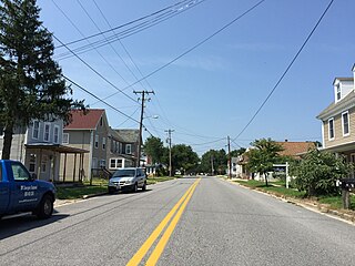
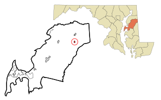
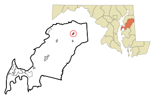
Grantsville is a town in the northern part of Garrett County, Maryland, United States, near the Pennsylvania border. The population was 968 as of the 2020 census.

<span class="mw-page-title-main">Kitzmiller, Maryland</span> Town in Maryland, United States

Kitzmiller is a town in Garrett County, Maryland, United States. The population was 321 at the 2010 census.

<span class="mw-page-title-main">Barclay, Maryland</span> Town in Maryland, United States

Barclay is a town in Queen Anne's County, Maryland, United States. The population was 120 at the 2010 census.

<span class="mw-page-title-main">Sudlersville, Maryland</span> Town in Maryland, United States

Sudlersville is a town in the far northeastern corner of Queen Anne's County, Maryland, United States. The ZIP code is 21668 and the area code is 410. The population was 497 at the 2010 census. It is perhaps best known as the hometown of Baseball Hall Of Fame slugger Jimmie Foxx. Other famous residents include astronomer and mathematician Simon Newcomb.

<span class="mw-page-title-main">Pittsville, Maryland</span> Town in Maryland, United States

Pittsville is a town in Wicomico County, Maryland, United States. The population was 1,417 at the 2010 census. It is included in the Salisbury, Maryland-Delaware Metropolitan Statistical Area.

<span class="mw-page-title-main">Brinckerhoff, New York</span> Census-designated place in New York, United States

Brinckerhoff is a hamlet and census-designated place (CDP) in Dutchess County, New York, United States. The population was 2,900 at the 2010 census. It is part of the Poughkeepsie–Newburgh–Middletown, NY Metropolitan Statistical Area as well as the larger New York–Newark–Bridgeport, NY-NJ-CT-PA Combined Statistical Area.

<span class="mw-page-title-main">Sugarcreek, Ohio</span> Village in Ohio, United States

Sugarcreek is a village in Tuscarawas County, Ohio, United States. The population was 2,373 at the 2020 census. It is known as "The Little Switzerland of Ohio." Located in Ohio's Amish Country, the village is part of a large regional tourism industry. In the center of town stands one of the world's largest cuckoo clocks, which was previously featured on the cover of the Guinness World Records book in 1977.

<span class="mw-page-title-main">Taft Southwest, Texas</span> CDP in Texas, United States

Taft Southwest is a census-designated place (CDP) in San Patricio County, Texas, United States. The population was 1,460 at the 2010 census.

<span class="mw-page-title-main">Hampstead, Maryland</span> Town in Maryland, United States

Hampstead is a town in Carroll County in the U.S. state of Maryland. The population was 6,323 at the 2010 census.

<span class="mw-page-title-main">Templeville, Maryland</span> Town in Maryland, United States

Templeville is a town in Caroline and Queen Anne's counties, Maryland, United States. Templeville is located near the Maryland-Delaware line. The population was 138 at the 2010 census. It was known as Bullock Town until the name was changed in 1847. The name Templeville derives from the Temple family, whose most famous member was Governor William Temple of Delaware.

References

  1. "Cecilton". Maryland Manual. Retrieved June 25, 2017.
  2. "2020 U.S. Gazetteer Files". United States Census Bureau. Retrieved April 26, 2022.
  3. "US Gazetteer files: 2010, 2000, and 1990". United States Census Bureau. February 12, 2011. Retrieved April 23, 2011.
  4. "US Gazetteer files 2010". United States Census Bureau. Archived from the original on January 25, 2012. Retrieved January 25, 2013.
  5. "Cecilton Elects First Town Board in 1864". Window on Cecil County's Past. May 17, 2012.
  6. "National Register Information System". National Register of Historic Places . National Park Service. April 15, 2008.
  7. Kinnaly, Kevin (November 16, 2017). "Cecil Transit Adds New "Demand Response" Route". Maryland Association of Counties. Retrieved June 18, 2019.
  8. "Census of Population and Housing". Census.gov. Retrieved June 4, 2015.
  9. "U.S. Census website". United States Census Bureau . Retrieved January 25, 2013.
  10. "U.S. Census website". United States Census Bureau . Retrieved January 31, 2008.
  11. "Maryland Amish". Amish America. March 2011. Retrieved October 6, 2017.
  12. Guy, Chris (June 27, 2003). "Match made in Cecil County". The Baltimore Sun. Retrieved October 9, 2017.
  13. Encyclopedia Britannica, United States Jurist and Politician
    - "DAVIS, David". Biographical Directory of the United States Cobgress.