Port Deposit, Maryland

Last updated

Port Deposit, Maryland
Port Deposit, Maryland.jpg
Downtown Port Deposit (2021)
Flag of Port Deposit, Maryland.png
Seal of Port Deposit, Maryland.png
Cecil County Maryland Incorporated and Unincorporated areas Port Deposit Highlighted.svg
Location of Port Deposit, Maryland
Coordinates: 39°36′39″N76°6′1″W / 39.61083°N 76.10028°W / 39.61083; -76.10028
Country Flag of the United States.svg United States
State Flag of Maryland.svg  Maryland
County Flag of Cecil County, Maryland.gif Cecil
Incorporated 1824 [1]
Government
  MayorWayne Tome Jr.
Area
[2]
  Total2.27 sq mi (5.87 km2)
  Land2.26 sq mi (5.86 km2)
  Water0.01 sq mi (0.01 km2)
Elevation
49 ft (15 m)
Population
 (2020)
  Total614
  Density271.44/sq mi (104.79/km2)
Time zone UTC−5 (Eastern (EST))
  Summer (DST) UTC−4 (EDT)
ZIP code
21904
Area code 410
FIPS code 24-63075
GNIS feature ID0591049
Website http://www.portdeposit.org/
Port Deposit
USA Maryland location map.svg
Red pog.svg
Usa edcp location map.svg
Red pog.svg
LocationE bank of Susquehanna River 10 mi. (16 km) S of Mason-Dixon Line, Port Deposit, Maryland
Area280 acres (113.3 ha)
Architectural styleSecond Empire, Queen Anne, Georgian
NRHP reference No. 78001452 [3]
Added to NRHPMay 23, 1978

Port Deposit is a town in Cecil County, Maryland, United States. It is located on the east bank of the Susquehanna River near its discharge into the Chesapeake Bay. The population was 653 at the 2010 census.

Contents

Geography

Main Street in historic Port Deposit Port Deposit P3260067.JPG
Main Street in historic Port Deposit

Port Deposit is located at 39°36′39″N76°6′1″W / 39.61083°N 76.10028°W / 39.61083; -76.10028 (39.610915, -76.100172). [4]

According to the United States Census Bureau, the town has a total area of 2.28 square miles (5.91 km2), of which 2.27 square miles (5.88 km2) is land and 0.01 square miles (0.03 km2) is water. [5]

It is the westernmost incorporated municipality in Cecil County, as well as in the Philadelphia-Camden-Wilmington, PA-NJ-DE-MD Metropolitan Statistical Area, better known as the Delaware Valley.

History

Early history

The first recorded European visits to the area were the 1608 and 1609 expeditions led by Captain John Smith up the Chesapeake Bay. He sailed about 2 miles (3.2 km) up the Susquehanna River to the present location of Port Deposit, and gave the name of "Smythe Fayles" to the rapids just above the future town. [6] [7]

The upper ferry

Historic buildings in Port Deposit Port Deposit P3260066.JPG
Historic buildings in Port Deposit

In 1729, Thomas Cresap established a regular ferry service near Smith's Falls (in the upper Port Deposit area) crossing the Susquehanna to Lapidum; this was referred to as Smith's Ferry or Upper Ferry. [8] In 1731, a road from Susquehanna Upper Ferry toward Philadelphia, as far as the jurisdiction extends, was authorized. In the same year, in the jurisdiction south of the river, a petition was submitted for a road from the mill at 'Rock Run' [9] to Peach Bottom, Pennsylvania. This upper ferry was later purchased by Colonel John Creswell and came to be known as 'Creswell's Ferry'. [7] [10]

This location, and Lapidum across the river, were the northernmost navigable deepwater ports on the Susquehanna. River barges and wagons loaded with lumber, grain, coal, whiskey, tobacco, and other goods floated downriver to this "port of deposit", where cargo could be transferred to ships from the Chesapeake. In the early days, it was difficult to float goods downriver, since there were many rapids and hazards, but it remained the most convenient way for goods to leave much of the country drained by the Susquehanna above the falls. Further, since a number of roads converged at the ferry crossing, goods could be carted or "rolled." [11] [12] [10] [13]

As early as the 1790s, the forests on the Susquehanna were being logged and the timbers floated downriver to points near the ferry landing. In 1812, the town was platted as Creswell's Landing; months later, Governor Levin Winder signed a bill officially naming the town Port Deposite (it would lose the trailing "e" at some point in the future). [7]

The canal

The Susquehanna Canal (which had several owners and names over the years, including the Maryland Canal) was completed in 1812 and contributed much toward the town's growth. Until the canal was placed in service bypassing Smith's Falls, most of the traffic stopped at Lapidum, across the Susquehanna River since it was easier to run the rapids on the south side. However, the new canal the Susquehanna and Tidewater Canal on the north side of the river funneled the barge traffic into Port Deposit, stimulating rapid growth. [10]

Granite and bridges

The Gerry House was built in 1812. Lafayette was entertained here in 1824. Port Deposit MD Gerry House.JPG
The Gerry House was built in 1812. Lafayette was entertained here in 1824.

The first attempts to bridge the Susquehanna in Maryland were made by the Port Deposit Bridge Company, incorporated in 1808. Its attempts failed, so the Legislature in 1812 authorized another company to proceed. After completing a survey in 1813, which included the first written reference to Port Deposit, the company proposed a location that complied with the law but was longer than necessary. After petitioning for relief, the company was allowed to route the bridge closer to the falls, allowing it to be 1,000 feet (300 m) shorter. The Port Deposit Bridge, a wooden covered bridge, was built just north of Port Deposit during 1817 and 1818. Put into service in 1818, it was the earliest bridge crossing of the Susquehanna. Rebuilt after a span burned in 1823, it remained in service until 1857. [10]

A 4 acres (16,000 m2) site at the north end of Port Deposit was committed to quarrying "granite." (actually gneiss) [14] for bridges. The general area had been the site for granite quarrying before the bridge was constructed as there was use of this specific granite in buildings constructed before the Revolutionary War. This granite can be seen in many of the distinctive buildings in Port Deposit today. [7] [10]

Quarries were also opened here in 1829 by the proprietors of a competitor canal, the Susquehanna and Tidewater Canal, between Havre de Grace and Wrightsville, Pennsylvania, for canal construction projects routed along the opposite bank of the Susquehanna. [7] [10]

These quarries continued in service well into the 20th century. Port Deposit gneiss was used in: [7]

Incorporation

Town Hall Port Deposit MD Town Hall.JPG
Town Hall

Port Deposit was incorporated in 1824. [12]

Arrival of the railroad

More houses along main street in Port Deposit Port Deposit P3260068.JPG
More houses along main street in Port Deposit

In 1832, the governments of Maryland, Delaware, and Pennsylvania chartered a quartet of railroads to connect Baltimore and Philadelphia. The Maryland General Assembly chartered two railroads terminating at Port Deposit: the Baltimore and Port Deposite Rail Road Company to build a line from the Susquehanna's western bank to Baltimore; and the Delaware and Maryland Rail Road Company to build from the river's eastern bank to the Delaware state line. That same year, Delaware chartered the Wilmington and Susquehanna Rail Road Company to continue the line to Wilmington. In 1836, the D&M merged with the W&S to form the Wilmington and Susquehanna Railroad Company. On February 12, 1838, all three companies merged to form the Philadelphia, Wilmington and Baltimore Railroad Company, forging a continuous line from Philadelphia to Baltimore. The main line passed southeast of Port Deposit; the town was connected by a branch line in 1866, running along the riverbank from Perryville. In 1881, the PW&B came under the control of the Pennsylvania Railroad (PRR). In 1893 the branch line was sold to the Columbia and Port Deposit Railway, also PRR-controlled. [10] [13]

Jacob Tome

Jacob Tome arrived in Port Deposit penniless; became a banker, philanthropist, and politician; and died one of the richest men in the United States. He was to become Cecil County's first millionaire and its greatest philanthropist. The Tome mansion (built in 1850 but no longer standing) was the largest house in the town. In 1889, Tome founded the Jacob Tome School for Boys on Main Street, part of a system of schools called the Jacob Tome Institute. When he died on March 16, 1898, in Port Deposit, he left a substantial endowment for the institute, which the Tome School tapped to build a series of beaux arts granite buildings on the bluffs above Port Deposit, overlooking the Susquehanna River. [13]

The CP-TOME interlocking on the railroad line through downtown Port Deposit is named in his honor.

Damming the Susquehanna

The Susquehanna River drops 167 feet (51 m) as it passes through the region above Port Deposit, as it cuts through the hard rock of the region. This characteristic, which had long been good for Port Deposit, also attracted power companies in the boom period after World War I. The Conowingo Dam, built in 1927, permanently changed the character of the town by terminating all river traffic and decimating what was left of the shad and herring fishery which was once found there. Port Deposit benefited from the dam as well; destructive accumulations of ice (referred to as ice gouges) no longer accumulated in the Conowingo Rapids or passed through Port Deposit, [13] as it had to terrible effect in 1907.

Other industry

Formerly a major industry in Port Deposit, Wiley's Manufacturing, fabricated the Fort McHenry Tunnel sections. They were floated and towed to the Baltimore construction site using tugboats. Construction was completed in 1985. [12]

The immersed tubes of the 63rd Street Tunnel were fabricated at a shipyard in Port Deposit and then towed to New York City. [15]

National Register of Historic Places listing

Washington Hall as viewed from the Washington section of Amtrak's Broadway Limited in 1974. VIEW FROM AN AMTRAK PASSENGER TRAIN ENROUTE FROM HARRISBURG, PENNSYLVANIA, TO BALTIMORE, MARYLAND, AND WASHINGTON... - NARA - 556852.jpg
Washington Hall as viewed from the Washington section of Amtrak's Broadway Limited in 1974.

The entire town of Port Deposit was listed as a historic district on the National Register of Historic Places on May 23, 1978. Starting from Bainbridge Road on the south, the district extends about 1.4 miles north along US 222 to the quarry at the north end of town. [16]

The town has several impressive older buildings, many built of the local granite or brick. The oldest structures in the historic district date from 1725, with the majority built from 1830 through the 1890s. [12]

The town remained largely unspoiled by new construction until the late 20th century, since there was little room for construction. The bulk of the older buildings line the main street and the, until recently, single side street built in the narrow space between the bluffs and the river. The bluffs have been terraced and stairways lead between streets. Adams Hall, formerly part of the Tome Institute, became the Town Hall; the only remains of the Tome Institute's former Washington Hall is the granite doorway that separates the Main Street from a parking lot today. [13]

Police Department

During the second half of the twentieth century, Port Deposit maintained a small police department, mostly made up of parttime officers. Around 1966, the town council promoted Horace Boddy, one of the parttime patrolman, to chief of police. He had joined the force in the early 1960s, and with the command appointment he became the first African American police chief in Cecil County. In 1980, Chief Boddy stepped down from the commanding role. His next senior officer, Bill Waibel, became the chief as Boddy stayed on the force as a patrolman. He retired fully in 1983. [17]

Transportation

MD 222 southbound in Port Deposit 2021-08-16 13 42 01 View south along Maryland State Route 222 (Main Street) at Maryland State Route 276 (Center Street) in Port Deposit, Cecil County, Maryland.jpg
MD 222 southbound in Port Deposit

The present-day primary method of transportation to and from Port Deposit is by road. Maryland Route 222 passes through the center of town along Main Street, connecting northwards to U.S. Route 1 near Conowingo Dam and southward to Perryville and Interstate 95, which is the nearest Interstate highway. Both US 1 and I-95 head north towards Philadelphia and south towards Baltimore. Maryland Route 276 also serves Port Deposit, heading northeast towards Rising Sun.

Demographics

Historical population
CensusPop.Note
1850 988
1870 1,839
1880 1,9506.0%
1890 1,908−2.2%
1900 1,575−17.5%
1910 1,394−11.5%
1920 1,090−21.8%
1930 963−11.7%
1940 883−8.3%
1950 1,13929.0%
1960 953−16.3%
1970 906−4.9%
1980 664−26.7%
1990 6853.2%
2000 676−1.3%
2010 653−3.4%
2020 614−6.0%
U.S. Decennial Census [18]

2010 census

As of the census [19] of 2010, there were 653 people, 265 households, and 153 families living in the town. The population density was 287.7 inhabitants per square mile (111.1/km2). There were 429 housing units at an average density of 189.0 per square mile (73.0/km2). The racial makeup of the town was 82.8% White, 11.9% African American, 1.4% Native American, 0.6% Asian, 0.6% from other races, and 2.6% from two or more races. Hispanic or Latino of any race were 3.2% of the population.

There were 265 households, of which 26.0% had children under the age of 18 living with them, 35.8% were married couples living together, 14.0% had a female householder with no husband present, 7.9% had a male householder with no wife present, and 42.3% were non-families. 30.6% of all households were made up of individuals, and 5.7% had someone living alone who was 65 years of age or older. The average household size was 2.39 and the average family size was 2.89.

The median age in the town was 39.4 years. 19.4% of residents were under the age of 18; 10.2% were between the ages of 18 and 24; 26.8% were from 25 to 44; 32.8% were from 45 to 64; and 10.9% were 65 years of age or older. The gender makeup of the town was 53.9% male and 46.1% female.

2000 census

As of the census [20] of 2000, there were 676 people, 264 households, and 163 families living in the town. The population density was 404.8 inhabitants per square mile (156.3/km2). There were 402 housing units at an average density of 240.7 per square mile (92.9/km2). The racial makeup of the town was 78.85% White, 17.75% African American, 0.44% Native American, 0.59% Asian, 0.59% from other races, and 1.78% from two or more races. Hispanic or Latino of any race were 1.63% of the population.

There were 264 households, out of which 29.9% had children under the age of 18 living with them, 34.1% were married couples living together, 21.6% had a female householder with no husband present, and 37.9% were non-families. 29.5% of all households were made up of individuals, and 9.5% had someone living alone who was 65 years of age or older. The average household size was 2.50 and the average family size was 3.08.

In the town, the population was spread out, with 27.5% under the age of 18, 8.1% from 18 to 24, 28.4% from 25 to 44, 26.8% from 45 to 64, and 9.2% who were 65 years of age or older. The median age was 36 years. For every 100 females, there were 109.3 males. For every 100 women age 18 and over, there were 100.0 men.

The median income for a household in the town was $34,167, and the median income for a family was $37,813. Males had a median income of $32,083 versus $21,932 for females. The per capita income for the town was $15,297. About 19.4% of families and 22.2% of the population were below the poverty line, including 35.4% of those under age 18 and 12.8% of those age 65 or over.

Notable residents

See also

Related Research Articles

<span class="mw-page-title-main">Cecil County, Maryland</span> County in the United States

Cecil County is a county located in the U.S. state of Maryland at the northeastern corner of the state, bordering both Pennsylvania and Delaware. As of the 2020 census, the population was 103,725. The county seat is Elkton.

<span class="mw-page-title-main">Columbia, Pennsylvania</span> Borough in Pennsylvania, United States

Columbia, formerly Wright's Ferry, is a borough (town) in Lancaster County, Pennsylvania, United States. As of the 2020 census, it had a population of 10,222. It is 28 miles (45 km) southeast of Harrisburg, on the east (left) bank of the Susquehanna River, across from Wrightsville and York County and just south of U.S. Route 30.

<span class="mw-page-title-main">Havre de Grace, Maryland</span> City in Maryland, United States

Havre de Grace, abbreviated HdG, is a city in Harford County, Maryland, United States. It is situated at the mouth of the Susquehanna River and the head of Chesapeake Bay. It is named after the port city of Le Havre, France, which in full was once Le Havre de Grâce.

<span class="mw-page-title-main">Susquehanna River</span> Major river in the Northeastern United States

The Susquehanna River is a major river located in the Mid-Atlantic region of the United States, overlapping between the lower Northeast. At 444 miles (715 km) long, it is the longest river on the East Coast of the United States. By watershed area, it is the 16th-largest river in the United States, and also the longest river in the early 21st-century continental United States without commercial boat traffic.

<span class="mw-page-title-main">Eastern Shore of Maryland</span> Part of the U.S. state of Maryland

The Eastern Shore of Maryland is a part of the U.S. state of Maryland that lies mostly on the east side of the Chesapeake Bay. Nine counties are normally included in the region. The Eastern Shore is part of the larger Delmarva Peninsula that Maryland shares with Delaware and Virginia.

<span class="mw-page-title-main">Conowingo Dam</span> Dam in Cecil and Harford counties, Maryland

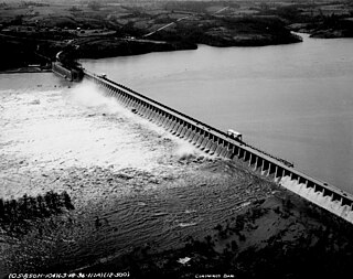
The Conowingo Dam is a large hydroelectric dam in the lower Susquehanna River near the town of Conowingo, Maryland. The medium-height, masonry gravity dam is one of the largest non-federal hydroelectric dams in the U.S., and the largest dam in the state of Maryland.

<span class="mw-page-title-main">Maryland Route 273</span> Highway in Maryland

Maryland Route 273 is a state highway in the U.S. state of Maryland. Known for most of its length as Telegraph Road, the highway runs 16.58 miles (26.68 km) from U.S. Route 1 near Harrisville east to the Delaware state line near Appleton, where the highway continues east as Delaware Route 273. MD 273 is the main east–west highway of northern Cecil County, connecting Conowingo, Port Deposit, and Rising Sun with Newark, Delaware, via the communities of Calvert and Fair Hill, where the highway intersects MD 272 and MD 213, respectively. The state highway also provides access to the Fair Hill Training Center and the Fair Hill Natural Resources Management Area.

<span class="mw-page-title-main">Maryland Route 222</span> Highway in Maryland

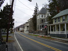
Maryland Route 222 (MD 222) is a state highway in the U.S. state of Maryland. The highway runs 11.36 miles (18.28 km) from MD 7 in Perryville north to U.S. Route 1 (US 1) near Conowingo. MD 222 connects Perryville, Port Deposit, and Conowingo along its route paralleling the Susquehanna River in western Cecil County. Due to limitations in the highway in Port Deposit, including a steep hill and a low-clearance railroad bridge, trucks are directed to use MD 275, MD 276, and US 1 through Woodlawn and Rising Sun to connect Interstate 95 (I-95) with US 222 in Conowingo.

<span class="mw-page-title-main">Tome School</span> Historic instution in Maryland, US

The Tome School is a private school in North East in Cecil County in the U.S. state of Maryland. Founded in 1894 by Jacob Tome, it is one of the oldest schools in Maryland. It enrolls grades K–12. As of 2022, the Head of School is Christine Szymanski.

<span class="mw-page-title-main">Jacob Tome</span> American politician (1810)

Jacob Tome was an American banker, philanthropist, and politician who died as one of the richest men in the United States. He was the first millionaire of Cecil County, Maryland, and an accomplished philanthropist, giving money to colleges, churches, and schools, including establishing the Tome School.

<span class="mw-page-title-main">Conowingo, Maryland</span> Unincorporated community in Maryland, United States

Conowingo is a community in northwestern Cecil County, Maryland, United States. The community replaced a previous one that was inundated by a reservoir.

<span class="mw-page-title-main">Conowingo Bridge</span> Bridge in Maryland, US

Several incarnations of the Conowingo Bridge crossed the Susquehanna River at the original location of Conowingo, Maryland, United States, about two miles upstream of the Conowingo Dam, which replaced it.

<span class="mw-page-title-main">U.S. Route 1 in Maryland</span> Section of U.S. Route in Maryland, United States

U.S. Route 1 (US 1) is the easternmost and longest of the major north–south routes of the older 1920s era United States Numbered Highway System, running from Key West, Florida, to Fort Kent, Maine. In the U.S. state of Maryland, it runs 81 miles (130 km) from the Washington, D.C. line to the Pennsylvania state line near the town of Rising Sun.

<span class="mw-page-title-main">Lapidum, Maryland</span>

Lapidum is a ghost town in Harford County, Maryland, USA, located at the head of navigation of the Susquehanna River on the west bank across from Port Deposit.

<span class="mw-page-title-main">Susquehanna and Tidewater Canal</span> Canal in Pennsylvania and Maryland

The Susquehanna and Tidewater Canal between Wrightsville, Pennsylvania, and Havre de Grace, Maryland, at the head of Chesapeake Bay, provided an interstate shipping alternative to 19th-century arks, rafts, and boats plying the difficult waters of the lower Susquehanna River. Built between 1836 and 1840, it ran 43 miles (69 km) along the west bank of the river and rendered obsolete an older, shorter canal along the east bank. Of its total length, 30 miles (48 km) were in Pennsylvania and 13 miles (21 km) in Maryland. Although rivalry between Philadelphia, Pennsylvania, and Baltimore, Maryland, delayed its construction, the finished canal brought increased shipments of coal and other raw materials to both cities from Pennsylvania's interior. Competition from railroads was a large factor in the canal's decline after 1855. Canal remnants, including a lock keeper's house, have been preserved in Maryland, and locks 12 and 15 have been preserved in Pennsylvania.

Cecil County Public Schools is a public school system serving the residents of Cecil County, Maryland. Demographics, assessments, and statistics are available on the Maryland Report Card website.

<span class="mw-page-title-main">Louis Wernwag</span>

Louis Wernag was a bridge builder in the United States in the early 19th century.

<span class="mw-page-title-main">Port Deposit Gneiss</span>

The Port Deposit Gneiss is a Paleozoic gneiss formation in Cecil County, Maryland. It is described as a "Moderately to strongly deformed intrusive complex, chiefly composed of quartz diorite gneiss. Rock types include gneissic biotite-quartz diorite, hornblende-biotite-quartz diorite, and biotite granodiorite, with minor amounts of quartz monzonite and hornblende-quartz diorite. Moderate protoclastic foliation grades into strong cataclastic shearing." It intrudes into the Volcanic Complex of Cecil County.

Robert R. Vandiver was an American politician and contractor from Maryland. He served as a member of the Maryland House of Delegates, representing Harford County, in 1868.

References

  1. "Port Deposit". Maryland Manual. Retrieved June 25, 2017.
  2. "2020 U.S. Gazetteer Files". United States Census Bureau. Retrieved April 26, 2022.
  3. "National Register Information System". National Register of Historic Places . National Park Service. July 9, 2010.
  4. "US Gazetteer files: 2010, 2000, and 1990". United States Census Bureau. February 12, 2011. Retrieved April 23, 2011.
  5. "US Gazetteer files 2010". United States Census Bureau. Archived from the original on July 2, 2012. Retrieved January 25, 2013.
  6. Later to be identified as Conowingo
  7. 1 2 3 4 5 6
  8. There was a lower ferry at the mouth of the Susquehanna River.
  9. There were Rock Run mills on both sides of the Susquehanna near both ends of the bridge one in Port Deposit and one above Lapidum at the bridge head on the south side/
  10. 1 2 3 4 5 6 7 Johnston, George (1972) [1881]. History Of Cecil County, Md, And The Early Settlements Around The Head Of Chesapeake Bay And On The Delaware River. Regional Publishing, Baltimore.
  11. It was common in the early colonies to load goods in large sturdy barrels or drums, which were then hitched to oxen and rolled to their destination.
  12. 1 2 3 4 Maryland A to Z: a topographical dictionary by Marion J. Kaminkow; Magna Carta Book Co.; Baltimore, MD, U.S.A.; 1985.
  13. 1 2 3 4 5 George J. Andreve (1976). "National Register of Historic Places Registration: Port Deposit" (PDF). Maryland Historical Trust. Retrieved January 1, 2016.
  14. The formation is known by geologists as Port Deposit Gneiss. This gneiss has a granite-like appearance and had a dark color and an even, granular texture which made it easy to work; it was prized as a building stone.
  15. "63rd Street Tunnel" (PDF). International Tunneling and Underground Space Association. Archived from the original (PDF) on May 26, 2012. Retrieved October 16, 2011.
  16. "Port Deposit Historic District (Boundary Map)". Maryland Historical Trust. Retrieved July 22, 2013.
  17. admin (August 1, 2022). "Port Deposit Police Chief Horace Boddy -". Window on Cecil County's Past. Retrieved December 29, 2022.
  18. "Census of Population and Housing". Census.gov. Retrieved June 4, 2015.
  19. "U.S. Census website". United States Census Bureau . Retrieved January 25, 2013.
  20. "U.S. Census website". United States Census Bureau . Retrieved January 31, 2008.
  21. Henry Lee Lucas Dr. Joel Norriss