
Cecil County is a county located in the U.S. state of Maryland at the northeastern corner of the state, bordering both Pennsylvania and Delaware. As of the 2020 census, the population was 103,725. The county seat is Elkton. The county was named for Cecil Calvert, 2nd Baron Baltimore (1605–1675), the first Proprietary Governor of the Province (colony) of Maryland. It is part of the Philadelphia-Camden-Wilmington, PA-NJ-DE-MD Metropolitan Statistical Area. The county is located in Wilmington's Radio Market and Philadelphia's Designated Market Area.

Woodmore is an unincorporated area and census-designated place in Prince George's County, Maryland, United States. Per the 2020 census, the population was 4,513. The CDP is located within the boundaries of Route 193 to the west, Church Road to the east, Route 214 to the south and Route 50 to the north. Woodmore Road runs east and west through the center. It contains a large gated community and country club, developments of Woodmore Meadows, and Woodmore South on the south side, as well as various other custom built homes and farmland.

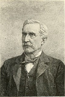
Matthew Tilghman was an American planter, and Revolutionary leader from Maryland. He served as a delegate to the Continental Congress from 1774 to 1776, where he signed the 1774 Continental Association.

Maryland Route 537 is a collection of unsigned state highways in the U.S. state of Maryland. These two existing highways and two former sections of state highway are segments of the old alignment of U.S. Route 213, which is now MD 213, in Chesapeake City in southern Cecil County. Some of the roads that became segments of MD 537 were constructed in the mid-1910s as part of the original state road between Elkton and Cecilton. Other portions of MD 537 were part of the approach roads to a bridge across the Chesapeake & Delaware Canal that was built in the mid-1920s and destroyed in 1942. After the modern Chesapeake City Bridge and its approach roads were completed in 1949, US 213 was moved to the new bridge and approach roads and MD 537 was assigned to the bypassed sections of US 213. Much of MD 537 outside of Chesapeake City was transferred to county maintenance in the late 1950s. In 2015, the remaining section of MD 537 north of the canal was turned over to municipal maintenance.

Maryland Route 310 is a state highway in the U.S. state of Maryland. Known as Cayots Corner Road, the highway runs 3.96 miles (6.37 km) from MD 213 at Cayots east to the Delaware state line east of St. Augustine in southern Cecil County. MD 310 was built east of St. Augustine by 1921 and west to what was then U.S. Route 213 in the early 1940s. MD 310 was extended west when US 213 was relocated at Cayots in the early 1950s.

Maryland Route 282 is a state highway in the U.S. state of Maryland. The highway runs 12.43 miles (20.00 km) from Crystal Beach east to the Delaware state line in Warwick, where the highway continues east as Delaware Route 299. MD 282 is the primary east–west highway of the Sassafras Neck between the Sassafras River and Bohemia River, connecting Crystal Beach, Earleville, and Warwick with MD 213 in Cecilton in southern Cecil County. The state highway was paved in Warwick by 1910 and constructed from Warwick to Cecilton in the late 1910s. West of Cecilton, what is today MD 282 consists of part of former MD 283, which ran from Crystal Beach to Earleville. MD 282 was constructed to Earleville in the early 1920s and extended a short distance west of Earleville in the late 1920s. MD 283 was constructed in the late 1920s and early 1930s. MD 282 was extended west to Crystal Beach along MD 283 in 1959. The highway from Cecilton to Crystal Beach was reconstructed in the late 1960s.
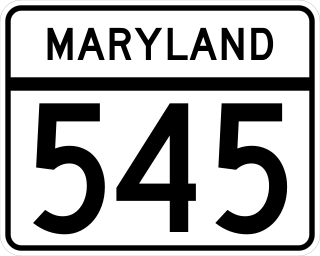
Maryland Route 545 is a state highway in the U.S. state of Maryland. Known for most of its length as Blue Ball Road, the state highway runs 5.92 miles (9.53 km) from MD 213 in Elkton north to Kirk Road and Warburton Road at Pleasant Hill in central Cecil County. MD 545 was constructed to Little Elk Creek near Childs in the early 1930s and extended to Pleasant Hill in the late 1940s.
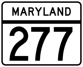
Maryland Route 277 is a state highway in the U.S. state of Maryland. The highway runs 2.51 miles (4.04 km) from Elk Mills east to MD 279 near Elkton in northeastern Cecil County. MD 277 was constructed west of MD 316 in the early 1920s. The highway was planned to be extended in both directions in the late 1940s. However, neither extension occurred until MD 277 was extended east to MD 279 in the mid-1980s.

Maryland Route 273 is a state highway in the U.S. state of Maryland. Known for most of its length as Telegraph Road, the highway runs 16.58 miles (26.68 km) from U.S. Route 1 near Harrisville east to the Delaware state line near Appleton, where the highway continues east as Delaware Route 273. MD 273 is the main east–west highway of northern Cecil County, connecting Conowingo, Port Deposit, and Rising Sun with Newark, Delaware, via the communities of Calvert and Fair Hill, where the highway intersects MD 272 and MD 213, respectively. The state highway also provides access to the Fair Hill Training Center and the Fair Hill Natural Resources Management Area.
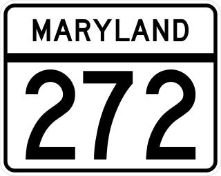
Maryland Route 272 is a state highway in the U.S. state of Maryland. The state highway runs 20.67 miles (33.27 km) from Turkey Point within Elk Neck State Park north through North East to the Pennsylvania state line near Calvert, where the highway continues as Pennsylvania Route 272. MD 272 is the main north–south highway of central Cecil County, connecting the Elk Neck Peninsula between the North East River and Elk River with U.S. Route 40 and Interstate 95 (I-95) in North East, MD 273 in Calvert, and Rising Sun via MD 274. The section of MD 272 between North East and Bay View was paved by 1910. The remainder of the state highway north to Calvert and south to Elk Neck was completed in several sections in the 1930s. The first relocations of MD 272 occurred when both railroads near North East were bridged in the early 1940s and mid-1950s. Multiple relocations occurred in the late 1950s and early 1960s along the whole length of the highway to eliminate curves and tie the state highway into I-95. MD 272 reached its current extent when it was extended south into Elk Neck State Park in 1979.

Rodgers Tavern, also known as Stevenson's Tavern, is a historic hotel located at Perryville, Cecil County, Maryland, United States. It is a mid-18th-century, two-story stone structure with a basement. All rooms have corner fireplaces. It was frequently visited by George Washington between the years 1755 and 1798, when it was owned and operated as an inn and tavern by Colonel John Rodgers (1728–1791). He was the father of John Rodgers (1772–1838), U.S. naval officer. During the 1880s the house was divided into two halves, east and west.

New Castle and Frenchtown Railroad Right-of-Way is a railroad right of way connecting Frenchtown, Cecil County, Maryland, and Porter, New Castle County, Delaware. The New Castle and Frenchtown Railroad originally crossed the Delmarva Peninsula from a wharf in New Castle to a wharf at Frenchtown on the Elk River in Maryland. This part of the right-of-way is abandoned for railroad purposes, although parts of it serve as county roads.
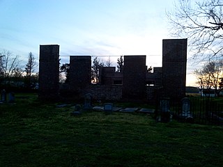
Coventry Parish Ruins are the remnants of a historic Episcopal church located at Rehobeth, Somerset County, Maryland. Coventry Parish was one of the original 30 Anglican parishes in the Province of Maryland established when Maryland's legislators established the Church of England as the colony's government-supported religion in 1692. These old parishes often had a church and several chapels of ease near population centers. This building, stands surrounded by farm fields and a historic Presbyterian Church near the Pocomoke River in what was then called Rehoboth but is now Rehobeth, Maryland to distinguish it from a beachfront community in Delaware.

John Lovet MacTavish was a Scots-Canadian heir to the North West Company and diplomat.
William Whann Mackall was a Seminole Wars veteran, Mexican–American War veteran and Confederate States Army brigadier general during the American Civil War. He was a United States Army officer for 24 years before he resigned his commission in order to join the Confederate Army. After the Civil War, he was a farmer in Fairfax County, Virginia.

The Oblate Sisters of St. Francis de Sales are a congregation of Roman Catholic Religious Sisters who base their spirituality on the teachings of St. Francis de Sales and St. Jane de Chantal.

All Saints Church, or All Saints Episcopal Church, founded in 1742, is a historic Episcopal church now located at 106 West Church Street in the Historic District of Frederick, Maryland. It is the seat of All Saints Parish, Diocese of Maryland, which covers most of Frederick County, Maryland and once covered most of Western Maryland.
Mount Aviat Academy is a Roman Catholic independent, co-educational school, located in Childs, Maryland. It is run independently within the Roman Catholic Diocese of Wilmington and is operated under the direction of the Oblate Sisters of St. Francis de Sales. The current enrollment is just about 250 students, from Delaware, Maryland, and Pennsylvania. Mount Aviat was selected as a 2014 National Blue Ribbon School of Excellence. This prestigious award is given annually to only 50 private schools nationwide.
The Eisenhower House, also known as "Mrs. Ray's Boarding House," is a historic house constructed in 1879 located in Laurel, Maryland in Prince George's, Maryland, United States listed in the Maryland Historical Trust.
Grace Snively was a community activist in the state of Maryland. Since the 1950s, she campaigned to improve gynaecological health with a focus on early cancer detection in segregated areas. She also promoted civil rights and voter registration and was involved in various charitable organisations. Having served as a chief election judge in Washington County, Maryland, she was inducted into the Maryland Women's Hall of Fame in 2006.


