
Cecil County is a county located in the U.S. state of Maryland at the northeastern corner of the state, bordering both Pennsylvania and Delaware. As of the 2010 census, the population was 101,108. The county seat is Elkton. The county was named for Cecil Calvert, 2nd Baron Baltimore (1605–1675), the first Proprietary Governor of the Province (colony) of Maryland. It is part of the Philadelphia-Camden-Wilmington, PA-NJ-DE-MD Metropolitan Statistical Area. Cecil County has existed since the late 1600s, though it continued to grow in population and town size. The county is located in Wilmington's Radio Market and Philadelphia's Designated Market Area.

Newark is a city in New Castle County, Delaware, United States. It is located 12 miles (19 km) west-southwest of Wilmington. According to the 2010 Census, the population of the city is 31,454. Newark is home to the University of Delaware.
Maryland Route 213 (MD 213) is a 68.25-mile (109.84 km) state highway located on the Eastern Shore of Maryland in the United States. The route runs from MD 662 in Wye Mills, Queen Anne's County north to the Pennsylvania border in Cecil County, where the road continues into that state as Pennsylvania Route 841 (PA 841). The route, which is a two-lane undivided highway most of its length, passes through mostly rural areas as well as the towns of Centreville, Chestertown, Galena, Cecilton, Chesapeake City, and Elkton. MD 213 intersects many routes including U.S. Route 50 (US 50) near Wye Mills, US 301 near Centreville, and US 40 in Elkton. It crosses over the Chesapeake & Delaware Canal in Chesapeake City on the Chesapeake City Bridge. MD 213 is designated by the state as the Chesapeake Country Scenic Byway between the southern terminus and Chesapeake City with the portion north of MD 18 in Centreville a National Scenic Byway. In addition, the route is also considered part of the Atlantic to Appalachians Scenic Byway between Chesapeake City and MD 273 in Fair Hill.

The Sassafras River is a tributary of the Chesapeake Bay on the Delmarva Peninsula in the United States. It is approximately 22 miles (35 km) long and starts in western New Castle County, Delaware, and along the boundary between Cecil County, Maryland on the north and Kent County, Maryland on the south. It rises southwest of Middletown, Delaware and ends at the Chesapeake Bay in a wide mouth between Howell Point near Betterton, Maryland and Grove Point on Grove Neck.

Maryland Route 273 is a state highway in the U.S. state of Maryland. Known for most of its length as Telegraph Road, the highway runs 16.58 miles (26.68 km) from U.S. Route 1 near Harrisville east to the Delaware state line near Appleton, where the highway continues east as Delaware Route 273. MD 273 is the main east–west highway of northern Cecil County, connecting Conowingo, Port Deposit, and Rising Sun with Newark, Delaware, via the communities of Calvert and Fair Hill, where the highway intersects MD 272 and MD 213, respectively. The state highway also provides access to the Fair Hill Training Center.

Fair Hill Training Center is a racehorse training center based in Fair Hill, Maryland. It was owned by William du Pont, Jr. of the well-known Du Pont family, who bought the land in 1926. Dupont invested a substantial amount of money to make the property a leading breeding and training farm for his Thoroughbred racehorses. The State of Maryland purchased Fair Hill in 1974, converting the then 5,700-acre (23 km2) property into an equine training complex and a natural resource center. There are 17 privately owned barns, with more than 450 stalls. Each barn has its own set of turn out paddocks and porta pens. Barns here at Fair Hill were individually named after some of the du Pont thoroughbred champions such as Parlo, Chevation and Fairy Chant.

White Clay Creek Preserve is a 1,255-acre (508 ha) Pennsylvania state park along the valley of White Clay Creek in London Britain Township in Chester County, Pennsylvania in the United States. The park was donated by the DuPont Company in 1984 for the purpose of "preserving the diverse and unique plant and animal species, and the rich cultural heritage of the area". Dupont also donated an additional 528 acres (214 ha) for the adjoining White Clay Creek State Park to the state of Delaware. White Clay Creek Preserve is 3 miles (4.8 km) north of Newark, Delaware on Pennsylvania Route 896.

Elk Neck State Park is a public recreation area located between Chesapeake Bay and the Elk River near the southern tip of the Elk Neck Peninsula in Cecil County, Maryland. The state park is home to the historic Turkey Point Light and offers land-based and water-based recreation. The park is located on MD 272, eight miles (13 km) south of the town of North East, and 13 miles (21 km) south of exit 100 on I-95. It is operated by the Maryland Department of Natural Resources.
The Maryland Department of Natural Resources (DNR) is a government agency in the state of Maryland charged with maintaining natural resources including state parks, public lands, state forests, state waterways, wildlife and recreation areas. Its headquarters are in Annapolis.

Gwynnbrook Wildlife Management Area is an 88-acre (36 ha) Wildlife Management Area in Owings Mills, Baltimore County, Maryland. The property is a former game farm that was purchased by Maryland in 1919, and is the oldest WMA in the state.
Earleville Wildlife Management Area is a Wildlife Management Area in Cecil County, Maryland. The area is managed as a hunting area for upland game.

Chapel Point State Park is an undeveloped public recreation area located on the Port Tobacco River, a tributary of the Potomac, in Charles County, Maryland. The state park offers fishing and hunting. Adjacent to the park, St. Ignatius Church and cemetery, the oldest continuous Roman Catholic parish in the United States, offers a scenic river view.
Elk Neck State Forest belongs to the Maryland Department of Natural Resources and is managed by the Maryland Forest Service, and is adjacent to the town of North East, in Cecil County. It is often confused with Elk Neck State Park, which lies further south, near the end of the same peninsula.

Greenbrier State Park is a public recreation area located on South Mountain, three miles (4.8 km) northeast of Boonsboro in Washington County, Maryland, USA. The state park has camping, hiking trails, and a 42-acre (17 ha) man-made lake. It is managed by the Maryland Department of Natural Resources.

Purse State Park is a former Maryland state park located on the Potomac River in Charles County that has been subsumed into the 1,365-acre (552 ha) Nanjemoy Wildlife Management Area. As the Purse Area, the former park is known for fossil hunting on the beaches of Wades Bay at the southern end of the Nanjemoy WMA. Fossil discoveries have included shark teeth and Cibicides.
The Islands of the Potomac Wildlife Management Area is a Wildlife Management Area (WMA) consisting of 30 islands in the Potomac River in Maryland along its border with the state of Virginia. It is administered by the Maryland Department of Natural Resources.

Sassafras is an unincorporated community in Kent County, Maryland, United States. The Lanthim House, built in the 1720s, served as a general store.
Zekiah Swamp is part of the Potomac River basin in Charles County, Maryland in the United States. The swamp is 21 miles (34 km) of braided stream stretching the length of Charles County and is a tributary of the Potomac River. It sits at an elevation of three feet (0.91 m) and 450 acres (180 ha) of its southern end is protected as the Zekiah Swamp Natural Environment Area. The Maryland Department of Natural Resources has the authority to purchase an additional 5,000 acres (2,000 ha) for the park. Charles County has moved to protect an additional 65,000 acres (26,000 ha) of the wetland. The headwaters of the swamp are protected as part of Cedarville State Forest. It was first accurately surveyed by John Henry Alexander, Maryland's official cartographer, in 1835, as "Allen's Fresh".
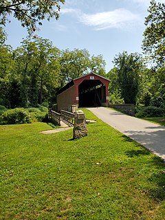
Foxcatcher Farm Covered Bridge, also known as Big Elk Creek Covered Bridge and Fair Hill Covered Bridge, is a Burr truss wooden covered bridge near Fair Hill, Maryland, United States.


