
The Chesapeake Bay is the largest estuary in the United States. The Bay is located in the Mid-Atlantic region and is primarily separated from the Atlantic Ocean by the Delmarva Peninsula with its mouth of the Bay at the south end located between Cape Henry and Cape Charles. With its northern portion in Maryland and the southern part in Virginia, the Chesapeake Bay is a very important feature for the ecology and economy of those two states, as well as others surrounding within its watershed. More than 150 major rivers and streams flow into the Bay's 64,299-square-mile (166,534 km2) drainage basin, which covers parts of six states and all of Washington, D.C. / District of Columbia.

The Delmarva Peninsula, or simply Delmarva, is a large peninsula on the East Coast of the United States, occupied by the vast majority of the state of Delaware and parts of the Eastern Shore regions of Maryland and Virginia. The peninsula is 170 miles (274 km) long. In width, it ranges from 70 miles (113 km) near its center, to 12 miles (19 km) at the isthmus on its northern edge, to less near its southern tip of Cape Charles. It is bordered by the Chesapeake Bay on the west, and the Delaware River, Delaware Bay, and the Atlantic Ocean on the east.

Arnold is a suburb of Annapolis and a census-designated place (CDP) in Anne Arundel County, Maryland, United States. The population was 23,106 at the 2010 census. Neighborhoods straddle College Parkway and Maryland Route 2. Arnold is located on the scenic Broadneck peninsula. The ZIP code is 21012.

Chesapeake Beach is a town in Calvert County, Maryland, United States. Its major attractions include the Chesapeake Beach Railway Station, the Chesapeake Beach Rail Trail, a water park, marinas, piers, and charter boat fishing. The town's population was recorded as 5,753 in the 2010 census.

Tangier is a town in Accomack County, Virginia, United States, on Tangier Island in Chesapeake Bay. The population was 727 at the 2010 census. Since 1850, the island's landmass has been reduced by 67%. Under the mid-range sea level rise scenario, much of the remaining landmass is expected to be lost in the next 50 years and the town will likely need to be abandoned.

Point Richmond, also sometimes referred to locally as The Point, is a neighborhood in Richmond, California, United States, near the eastern end of the Richmond-San Rafael Bridge, between Interstate 580 and the San Francisco Bay.

Curtis Bay is a residential / commercial / industrial neighborhood in the southern portion of the City of Baltimore, Maryland, United States.
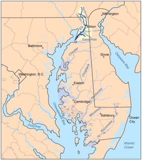
The Elk River is a tidal tributary of the Chesapeake Bay on the Eastern Shore of Maryland and on the northern edge of the Delmarva Peninsula. It is about 15 miles (24 km) long. As the most northeastern extension of the Chesapeake Bay estuary, it has served as one entrance to the Chesapeake & Delaware Canal since the 19th century. The canal and river now serve as one boundary of the Elk Neck Peninsula. The river flows through Cecil County, Maryland, with its watershed extending into New Castle County, Delaware and Chester County, Pennsylvania. Elkton, the county seat of Cecil County, is located at its head. Its total watershed area is 143 square miles (370 km2), with 21 square miles (54 km2) of open water, so its watershed is 15% open water. It is south and east of the North East River, and north of the Sassafras River.
The Near East Side is a neighborhood located near downtown Columbus, Ohio, made up of several neighborhoods: Mount Vernon, King-Lincoln Bronzeville, Eastgate, Franklin Park, Nelson Park, Olde Towne East, and Woodland Park.

The Northeast River is a tributary of the Chesapeake Bay in Maryland. Entirely tidal, it extends for about 5.0 miles (8.0 km) from the town of North East southwest past Charlestown to the main body of Chesapeake Bay between Carpenter's Point and Red Point. The river is fed by North East Creek and its tributaries, which reach as far north as just east of Nottingham, Pennsylvania. The Northeast River is entirely within Cecil County, Maryland, though its watershed extends into Chester County, Pennsylvania. Its watershed area in MD is 63 square miles (160 km2), with 6% impervious surface in 1994. On the 1612 John Smith map, it was referred to as Gunter's Harbour.

Helen Delich Bentley Port of Baltimore is a shipping port along the tidal basins of the three branches of the Patapsco River in Baltimore, Maryland on the upper northwest shore of the Chesapeake Bay. It is the nation's largest port facilities for specialized cargo and passenger facilities operated by the Maryland Port Administration (MPA), a unit of the Maryland Department of Transportation.

Brooklyn is one of the southernmost neighborhoods in Baltimore, Maryland. It is located near Anne Arundel County along Governor Ritchie Highway which is also Maryland Route 2. Its main roads are South Hanover Street,, Potee Street, and East Patapsco Avenue, Sixth Street, Tenth Street, and West Bay Avenue which borders the neighboring Curtis Bay community to the east, running through Bay Brook Park, which separates the two. South Hanover Street also serves as the dividing line between east-west streets in Brooklyn, as Charles Street does not exist here. Often mistaken as Brooklyn Park, Brooklyn shares the 21225 ZIP Code with the greater Brooklyn Park area which is across the Baltimore City Line in and the other neighboring community of Cherry Hill to the west and northwest across the now small western branch of the Patapsco River flowing from Ellicott City and Elkridge and along the shoreline-hugging southern extension "South Hanover Street" of the downtown's old colonial-era "Hanover Street" across the 1914-1917 Hanover Street Bridge, later renamed the Vietnam Veterans Memorial Bridge in the 1990s.
The Chesapeake Beach Railway (CBR), now defunct, was an American railroad of southern Maryland and Washington, D.C., built in the 19th century. The CBR ran 27.629 miles from Washington, D.C., on tracks formerly owned by the Southern Maryland Railroad and then on its own single track through Maryland farm country to a resort at Chesapeake Beach. It was built by Otto Mears, a Colorado railroad builder, who planned a shoreline resort with railroad service from Washington and Baltimore. It served Washington and Chesapeake Beach for almost 35 years, but the Great Depression and the rise of the automobile marked the end of the CBR. The last train left the station on April 15, 1935. Parts of the right-of-way are now used for roads and a future rail trail.

Elk Neck Peninsula is in Cecil County, Maryland, between the towns of Elkton and North East, Maryland. Native American and colonial travelers often canoed or sailed up the Chesapeake Bay to Elkton, where the Elk River became unnavigable, and then walked or took some form of surface transportation to the Delaware Bay watershed, since this was the shortest surface crossing. Native Americans of the area, including the Nanticoke and Lenni Lenape, hunted and fished, as well as established semi-permanent camps.

Maryland Route 261 is a state highway in the U.S. state of Maryland. The highway runs 12.86 miles (20.70 km) from MD 263 near Parran north to MD 778 at Friendship. MD 261 connects Prince Frederick with and serves as the main street through the Chesapeake Bay beach communities of Chesapeake Beach and North Beach in northeastern Calvert County and Rose Haven in southeastern Anne Arundel County. The highway was constructed from north of its present terminus through Chesapeake Beach in the early 1930s. The road was built as MD 613 east from Friendship in the mid-1930s and extended east to Rose Haven in the late 1940s. MD 261 was extended south to its present terminus near Parran and north through North Beach to Rose Haven in the mid-1950s. MD 261 took over MD 613 west to Friendship in the early 1960s.
Maryland Route 263 is a state highway in the U.S. state of Maryland. Known as Plum Point Road, the state highway runs 6.17 miles (9.93 km) from MD 2/MD 4 near Huntingtown east to a dead end at Plum Point. MD 263 also connects Prince Frederick with the northeastern Calvert County towns of Chesapeake Beach and North Beach; access to the towns is provided through a connection with MD 261 at Parran. The state highway was constructed in the late 1920s.

Harwood is a small neighborhood located in the north-central area of Baltimore, Maryland, USA. It sits east of Charles Village, south of Abell, west of Waverly and north of Barclay. Its boundaries are Guilford and Greenmount Avenues to the east and west, and 25th and 29th streets to the north and south. These streets together encompass about 14 city blocks.
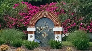
Lago Mar is a neighborhood on the north end of the Currituck Sound in the Princess Anne area of southeastern Virginia Beach, Virginia, United States. The name translated from Spanish to English means "lake" and "ocean". It is derived from its proximity to the Atlantic Ocean and Brinson's Inlet Lake, as well as from the neighboring community of Ocean Lakes. The street names within Lago Mar are also of Spanish origin with the notable exception of Atwoodtown, which is what the area was called prior to being renamed in the 1960s. Today, neighboring communities Ashby's Bridge, Lotus Creek, Mirasol, Parkway Estates, and parts of Sigma are sometimes included in greater Lago Mar, especially for real estate marketing or demographic purposes.
The Broadneck Peninsula is an area in Anne Arundel County, Maryland. The area is north of the Severn River, South of the Magothy River and west of the Chesapeake Bay. At the lower end of the Broadneck Peninsula is the 4.3 mile Chesapeake Bay Bridge.
