The Potomac River is a major river in the Mid-Atlantic region of the United States that flows from the Potomac Highlands in West Virginia to the Chesapeake Bay in Maryland. It is 405 miles (652 km) long, with a drainage area of 14,700 square miles (38,000 km2), and is the fourth-largest river along the East Coast of the United States and the 21st-largest in the United States. Over 5 million people live within its watershed.

The Chesapeake Bay is the largest estuary in the United States. The Bay is located in the Mid-Atlantic region and is primarily separated from the Atlantic Ocean by the Delmarva Peninsula, including parts of the Eastern Shore of Maryland, the Eastern Shore of Virginia, and the state of Delaware. The mouth of the Bay at its southern point is located between Cape Henry and Cape Charles. With its northern portion in Maryland and the southern part in Virginia, the Chesapeake Bay is a very important feature for the ecology and economy of those two states, as well as others surrounding within its watershed. More than 150 major rivers and streams flow into the Bay's 64,299-square-mile (166,534 km2) drainage basin, which covers parts of six states, New York, Pennsylvania, Delaware, Maryland, Virginia, and West Virginia, and all of Washington, D.C.

Port Tobacco, officially Port Tobacco Village, is a town in Charles County, in southern Maryland, United States. The population was 13 at the 2010 census, making Port Tobacco the smallest incorporated town in Maryland.

A shipwreck is the wreckage of a ship that is located either beached on land or sunken to the bottom of a body of water. Shipwrecking may be intentional or unintentional. There were approximately three million shipwrecks worldwide as of January 1999, according to Angela Croome, a science writer and author who specialized in the history of underwater archaeology.

The Patuxent River is a tributary of the Chesapeake Bay in the state of Maryland. There are three main river drainages for central Maryland: the Potomac River to the west passing through Washington, D.C., the Patapsco River to the northeast passing through Baltimore, and the Patuxent River between the two. The 908-square-mile (2,352 km2) Patuxent watershed had a rapidly growing population of 590,769 in 2000. It is the largest and longest river entirely within Maryland, and its watershed is the largest completely within the state.
Nanjemoy is a settlement along Maryland Route 6 in southwestern Charles County, Maryland, United States, and the surrounding large rural area more or less bounded by Nanjemoy Creek to the east and north, and the Potomac River to the south and west.
Thunder Bay National Marine Sanctuary and Underwater Preserve is a United States National Marine Sanctuary on Lake Huron's Thunder Bay, within the northeastern region of the U.S. state of Michigan. It protects an estimated 116 historically significant shipwrecks ranging from nineteenth-century wooden side-wheelers to twentieth-century steel-hulled steamers. There are a great many wrecks in the sanctuary, and their preservation and protection is a concern for national policymakers. The landward boundary of the sanctuary extends from the western boundary of Presque Isle County to the southern boundary of Alcona County. The sanctuary extends east from the lakeshore to the international border. Alpena is the largest city in the area.
San Pedro Underwater Archaeological Preserve State Park is a Florida State Park located in 18 feet (5.5 m) of water, approximately 1.25 nautical miles (2.32 km) south of Indian Key. It became the second Florida Underwater Archaeological Preserve when it opened to the public in 1989. The heart of the park is the San Pedro, a submerged shipwreck from a 1733 Spanish flotilla, around which visitors can dive and snorkel. The San Pedro, a 287-ton Dutch-built vessel, and 21 other Spanish ships under the command of Rodrigo de Torres left Havana, Cuba, on Friday, July 13, 1733, bound for Spain. The San Pedro carried a cargo of 16,000 silver Mexican pesos and crates of Chinese porcelain. A hurricane struck the fleet, while entering the Straits of Florida, and sank or swamped most of the fleet. The wrecksite includes an "eighteenth century anchor, replica cannons, ballast stones encrusted with coral, a dedication plaque, and a mooring buoy system." The wreck was added to the U.S. National Register of Historic Places on May 31, 2001.
Nanjemoy Creek is a 13.1-mile-long (21.1 km) tidal tributary of the Potomac River in Charles County, Maryland, United States, located between Cedar Point Neck and Tayloe's Neck. Its watershed area is 73 square miles (190 km2), with 2% impervious surface in 1994.
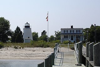
The Piney Point Lighthouse was built in 1836 located at Piney Point on the Potomac River in Maryland just up the river from the mouth of the Chesapeake Bay. The Coast Guard decommissioned it in 1964 and it has since become a museum. It is known as the Lighthouse of Presidents because several early US Presidents visited or stayed on the grounds.
Queen Anne in Prince George's County, Maryland, United States, is a former port on the Patuxent River. It was delineated as a CDP for the 2010 census, at which time it had a population of 1,280. Per the 2020 census, the population was 1,405.

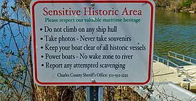
USCGC Cuyahoga (WIX-157) was an Active-class patrol boat built in 1927 which saw action in World War II. Cuyahoga sank after a night-time collision in the Chesapeake Bay while on patrol in 1978. She was later raised and re-sunk as an artificial reef off the Virginia coast and is a popular recreational dive site.

USS Scorpion was a self-propelled floating artillery battery in commission with the United States Navy from 1812 to 1814.

Gallinipper was a schooner that sank in Lake Michigan off the coast of Centerville, Manitowoc County, Wisconsin, United States. In 2010, the shipwreck site was added to the National Register of Historic Places.

Home was a two-masted schooner which sank in Lake Michigan off Centerville in Manitowoc County, Wisconsin, United States, in 1858. In 2010 the shipwreck site was added to the National Register of Historic Places.
The Nanjemoy Formation is a geologic formation pertaining to both the Wilcox Group and the Pamunkey Group of the eastern United States, stretching across the states of Virginia, Maryland, and District of Columbia. The formation crops out east of the Appalachians and dates back to the Paleogene period. Specifically to the Ypresian stage of the Eocene epoch, about 55 to 50 Ma or Wasatchian in the NALMA classification, defined by the contemporaneous Wasatch Formation of the Pacific US coast.

The Wisconsin Shipwreck Coast National Marine Sanctuary is one of 15 United States National Marine Sanctuaries administered by the National Oceanic and Atmospheric Administration (NOAA), an agency of the United States Department of Commerce; NOAA co-manages the sanctuary jointly with the State of Wisconsin. It is located in Lake Michigan along the coast of Wisconsin. It was created in 2021 to protect shipwrecks considered nationally important archaeological resources.

RV Bay Hydro II (S5401), sometimes rendered as R/V Bay Hydro II, is an American oceanographic research vessel in non-commissioned service in the fleet of the National Oceanic and Atmospheric Administration (NOAA) since 2009. She is registered as NOAA S5401.